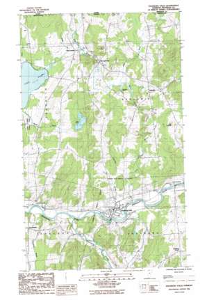
Enosburg Falls Topo Map Vermont
To zoom in, hover over the map of Enosburg Falls
USGS Topo Quad 44072h7 - 1:24,000 scale
| Topo Map Name: | Enosburg Falls |
| USGS Topo Quad ID: | 44072h7 |
| Print Size: | ca. 21 1/4" wide x 27" high |
| Southeast Coordinates: | 44.875° N latitude / 72.75° W longitude |
| Map Center Coordinates: | 44.9375° N latitude / 72.8125° W longitude |
| U.S. State: | VT |
| Filename: | o44072h7.jpg |
| Download Map JPG Image: | Enosburg Falls topo map 1:24,000 scale |
| Map Type: | Topographic |
| Topo Series: | 7.5´ |
| Map Scale: | 1:24,000 |
| Source of Map Images: | United States Geological Survey (USGS) |
| Alternate Map Versions: |
Enosburg Falls VT 1986, updated 1987 Download PDF Buy paper map Enosburg Falls VT 2012 Download PDF Buy paper map Enosburg Falls VT 2015 Download PDF Buy paper map |
1:24,000 Topo Quads surrounding Enosburg Falls
Highgate Center |
Sheldon Springs |
Enosburg Falls |
Richford |
Jay Peak |
Saint Albans |
Fairfield |
Bakersfield |
Cold Hollow Mountains |
Hazens Notch |
Milton |
Gilson Mountain |
Jeffersonville |
Johnson |
Eden |
> Back to 44072e1 at 1:100,000 scale
> Back to 44072a1 at 1:250,000 scale
> Back to U.S. Topo Maps home
Enosburg Falls topo map: Gazetteer
Enosburg Falls: Airports
Enosburg Airfield elevation 119m 390′Enosburg Falls Armory Heliport elevation 121m 396′
Enosburg Falls: Dams
Enosburg Falls Dam elevation 114m 374′Lake Carmi Dam elevation 132m 433′
Enosburg Falls: Forests
Enosburg Falls Municipal Forest elevation 162m 531′Enosburg Falls: Lakes
Burleson Pond elevation 170m 557′Little Pond elevation 206m 675′
Enosburg Falls: Pillars
Little Pinnacle elevation 252m 826′Enosburg Falls: Populated Places
Beattys Four Corners elevation 174m 570′Berkshire elevation 216m 708′
East Franklin elevation 133m 436′
East Sheldon elevation 173m 567′
Enosburg Center elevation 261m 856′
Enosburg Falls elevation 129m 423′
North Enosburg elevation 115m 377′
South Franklin elevation 106m 347′
South Franklin elevation 200m 656′
West Berkshire elevation 162m 531′
Enosburg Falls: Post Offices
Enosburg Falls Post Office elevation 116m 380′Enosburg Falls: Reservoirs
Enosburg Falls Reservoir elevation 150m 492′Enosburg Falls: Streams
Alder Run elevation 141m 462′Giddings Brook elevation 108m 354′
Goodsell Brook elevation 119m 390′
Marsh Brook elevation 133m 436′
Mineral Brook elevation 166m 544′
Sisco Brook elevation 128m 419′
Trout Brook elevation 116m 380′
Tyler Branch elevation 112m 367′
Enosburg Falls digital topo map on disk
Buy this Enosburg Falls topo map showing relief, roads, GPS coordinates and other geographical features, as a high-resolution digital map file on DVD:
New York, Vermont, Connecticut & Western Massachusetts
Buy digital topo maps: New York, Vermont, Connecticut & Western Massachusetts


