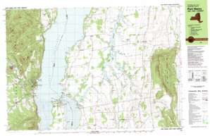
Snake Mountain Topo Map Vermont
To zoom in, hover over the map of Snake Mountain
USGS Topo Quad 44073a3 - 1:25,000 scale
| Topo Map Name: | Snake Mountain |
| USGS Topo Quad ID: | 44073a3 |
| Print Size: | ca. 39" wide x 24" high |
| Southeast Coordinates: | 44° N latitude / 73.25° W longitude |
| Map Center Coordinates: | 44.0625° N latitude / 73.375° W longitude |
| U.S. State: | VT |
| Filename: | k44073a3.jpg |
| Download Map JPG Image: | Snake Mountain topo map 1:25,000 scale |
| Map Type: | Topographic |
| Topo Series: | 7.5´x15´ |
| Map Scale: | 1:25,000 |
| Source of Map Images: | United States Geological Survey (USGS) |
| Alternate Map Versions: |
Port Henry VT 1980, updated 1981 Download PDF Buy paper map |
1:24,000 Topo Quads surrounding Snake Mountain
> Back to 44073a1 at 1:100,000 scale
> Back to 44072a1 at 1:250,000 scale
> Back to U.S. Topo Maps home
Snake Mountain topo map: Gazetteer
Snake Mountain: Airports
Staton Airport elevation 44m 144′Yankee Kingdom Airport elevation 69m 226′
Snake Mountain: Bays
Bulwagga Bay elevation 29m 95′Craig Harbor elevation 30m 98′
Mullen Bay elevation 30m 98′
Owls Head Bay elevation 29m 95′
Potash Bay elevation 29m 95′
Stevenson Bay elevation 29m 95′
Snake Mountain: Bridges
Lake Champlain Toll Bridge elevation 29m 95′Lake Champlain Toll Bridge elevation 29m 95′
Snake Mountain: Capes
Coffin Point elevation 34m 111′Crane Point elevation 30m 98′
Crane Point elevation 31m 101′
Crown Point elevation 46m 150′
Elm Point elevation 30m 98′
Lapstone Point elevation 37m 121′
Orchard Point elevation 31m 101′
Oven Point elevation 35m 114′
Potash Point elevation 40m 131′
Snake Mountain: Dams
Brilyea East Dam elevation 27m 88′Brilyea West Dam elevation 27m 88′
Farrell Dam elevation 37m 121′
Jerome Dam elevation 27m 88′
Tetrault Dam elevation 38m 124′
Snake Mountain: Lakes
Mill Pond elevation 149m 488′Snake Mountain: Parks
Dead Creek Wildlife Management Area elevation 60m 196′Snake Mountain: Populated Places
Addison elevation 98m 321′Chimney Point elevation 37m 121′
Goodrich Corner elevation 62m 203′
Palmer Corner elevation 63m 206′
Port Henry elevation 74m 242′
West Addison elevation 56m 183′
Willow Point elevation 29m 95′
Snake Mountain: Streams
Bartlett Brook elevation 162m 531′Beaver Brook elevation 29m 95′
East Branch Dead Creek elevation 27m 88′
Grove Brook elevation 29m 95′
Hospital Creek elevation 29m 95′
Kenney Brook elevation 36m 118′
McKenzie Brook elevation 29m 95′
Middle Branch Dead Creek elevation 27m 88′
Mill Brook elevation 29m 95′
Mullen Brook elevation 29m 95′
Stony Brook elevation 31m 101′
Wards Creek elevation 29m 95′
West Branch Dead Creek elevation 27m 88′
Snake Mountain: Summits
Bald Peak elevation 624m 2047′Burns Mountain elevation 233m 764′
Cheney Mountain elevation 354m 1161′
Colligan Hill elevation 187m 613′
Cook Mountain elevation 460m 1509′
Coot Hill elevation 324m 1062′
Quinn Mountain elevation 396m 1299′
Snake Mountain elevation 394m 1292′
Sullivan Hill elevation 254m 833′
Two Top Mountain elevation 467m 1532′
Walton Mountain elevation 212m 695′
Snake Mountain: Swamps
Black Ash Swamp elevation 308m 1010′Cranberry Bog elevation 311m 1020′
Snake Mountain digital topo map on disk
Buy this Snake Mountain topo map showing relief, roads, GPS coordinates and other geographical features, as a high-resolution digital map file on DVD:
New York, Vermont, Connecticut & Western Massachusetts
Buy digital topo maps: New York, Vermont, Connecticut & Western Massachusetts


