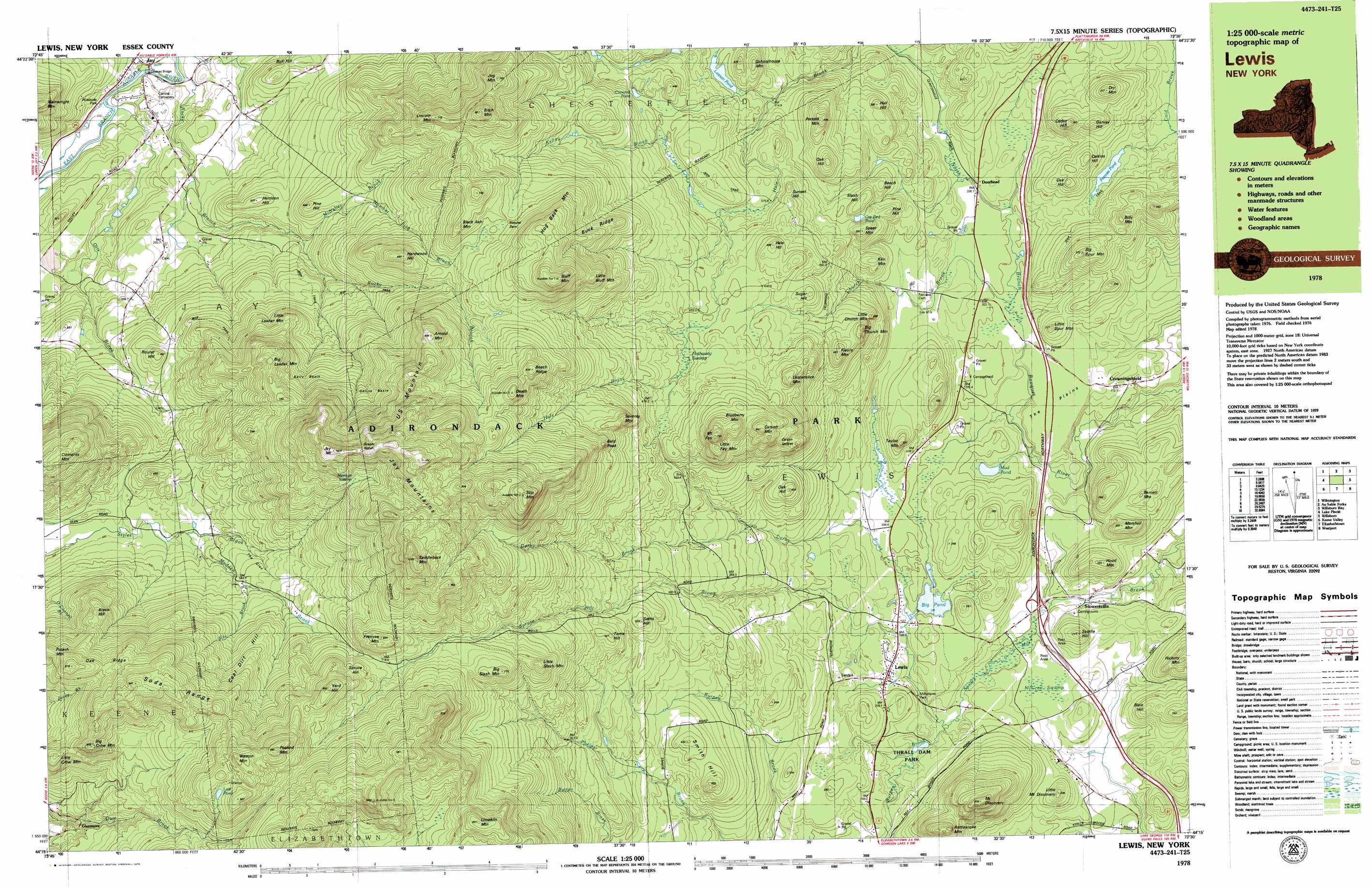
Lewis Topo Map New York
To zoom in, hover over the map of Lewis
USGS Topo Quad 44073c5 - 1:25,000 scale
| Topo Map Name: | Lewis |
| USGS Topo Quad ID: | 44073c5 |
| Print Size: | ca. 39" wide x 24" high |
| Southeast Coordinates: | 44.25° N latitude / 73.5° W longitude |
| Map Center Coordinates: | 44.3125° N latitude / 73.625° W longitude |
| U.S. State: | NY |
| Filename: | k44073c5.jpg |
| Download Map JPG Image: | Lewis topo map 1:25,000 scale |
| Map Type: | Topographic |
| Topo Series: | 7.5´x15´ |
| Map Scale: | 1:25,000 |
| Source of Map Images: | United States Geological Survey (USGS) |
| Alternate Map Versions: |
Lewbeach NY 1978, updated 1979 Download PDF Buy paper map Lewis NY 1999, updated 2000 Download PDF Buy paper map |
1:24,000 Topo Quads surrounding Lewis
Redford |
Peasleeville |
Peru |
Keeseville |
Colchester Point |
Wilmington |
Clintonville |
Juniper Island |
||
Keene |
Lewis |
Charlotte |
||
Keene Valley |
Elizabethtown |
Vergennes West |
||
Dix Mountain |
Witherbee |
Snake Mountain |
> Back to 44073a1 at 1:100,000 scale
> Back to 44072a1 at 1:250,000 scale
> Back to U.S. Topo Maps home
Lewis topo map: Gazetteer
Lewis: Basins
Gelina Basin elevation 697m 2286′Kelly Basin elevation 616m 2020′
Lewis: Benches
Carson Ledges elevation 496m 1627′Lewis: Bridges
Jay Covered Bridge elevation 179m 587′Lewis: Flats
The Plains elevation 195m 639′Lewis: Gaps
Grassy Notch elevation 1000m 3280′Lewis: Lakes
Big Pond elevation 188m 616′Coonrod Pond elevation 397m 1302′
Frances Pond elevation 223m 731′
Lawson Pond elevation 346m 1135′
Lost Pond elevation 865m 2837′
Mud Pond elevation 189m 620′
Ore Bed Pond elevation 334m 1095′
Lewis: Mines
Lewis Quarry elevation 200m 656′Lewis: Parks
Milholland Park elevation 176m 577′Thrall Dam Park elevation 167m 547′
Lewis: Populated Places
Crowningshield elevation 171m 561′Deerhead elevation 206m 675′
Glenmore elevation 548m 1797′
Lewis elevation 203m 666′
Stowersville elevation 142m 465′
Lewis: Ranges
Soda Range elevation 921m 3021′Lewis: Ridges
Beech Ridge elevation 836m 2742′Buck Ridge elevation 629m 2063′
Oak Ridge elevation 805m 2641′
Lewis: Streams
Burpee Brook elevation 156m 511′Church Brook elevation 197m 646′
Derby Brook elevation 189m 620′
Kelley Brook elevation 382m 1253′
Kiln Brook elevation 539m 1768′
Madden Brook elevation 472m 1548′
McNalley Brook elevation 337m 1105′
Number Five Brook elevation 398m 1305′
O'Connell Brook elevation 528m 1732′
Otis Brook elevation 192m 629′
Rocky Branch elevation 191m 626′
Lewis: Summits
Arnold Mountain elevation 853m 2798′Bald Peak elevation 706m 2316′
Barnett Mountain elevation 248m 813′
Beech Hill elevation 345m 1131′
Big Church Mountain elevation 468m 1535′
Big Crow Mountain elevation 857m 2811′
Big Lawler Mountain elevation 754m 2473′
Big Slash Mountain elevation 771m 2529′
Big Spur Mountain elevation 372m 1220′
Billy Mountain elevation 356m 1167′
Bissle Hill elevation 740m 2427′
Bitch Mountain elevation 797m 2614′
Black Ash Mountain elevation 728m 2388′
Blais Hill elevation 234m 767′
Blueberry Mountain elevation 645m 2116′
Bluff Mountain elevation 893m 2929′
Bull Hill elevation 330m 1082′
Calkins Hill elevation 314m 1030′
Carson Mountain elevation 642m 2106′
Cedar Hill elevation 361m 1184′
Clements Mountain elevation 782m 2565′
Coal Dirt Hill elevation 892m 2926′
Death Mountain elevation 865m 2837′
Dry Mountain elevation 375m 1230′
Fleury Mountain elevation 478m 1568′
Frenyea Mountain elevation 807m 2647′
Garvey Hill elevation 342m 1122′
Hale Hill elevation 494m 1620′
Hall Hill elevation 365m 1197′
Hardwood Hill elevation 683m 2240′
Harrison Hill elevation 372m 1220′
Hickory Mountain elevation 311m 1020′
Hog Back Mountain elevation 812m 2664′
Hood Mountain elevation 255m 836′
Jay Mountain elevation 1026m 3366′
Jay Mountains elevation 1008m 3307′
Jug Mountain elevation 742m 2434′
Kiln Mountain elevation 334m 1095′
Lesperance Mountain elevation 532m 1745′
Limekiln Mountain elevation 889m 2916′
Lincoln Mountain elevation 714m 2342′
Little Bluff Mountain elevation 746m 2447′
Little Church Mountain elevation 406m 1332′
Little Crow Mountain elevation 783m 2568′
Little Fay Mountain elevation 642m 2106′
Little Lawler Mountain elevation 583m 1912′
Little Mount Discovery elevation 255m 836′
Little Slash Mountain elevation 744m 2440′
Little Spur Mountain elevation 271m 889′
Marshall Mountain elevation 285m 935′
Mount Discovery elevation 473m 1551′
Mount Fay elevation 701m 2299′
Oak Hill elevation 422m 1384′
Oak Hill elevation 311m 1020′
Oak Hill elevation 454m 1489′
Peaked Mountain elevation 982m 3221′
Perkett Mountain elevation 467m 1532′
Pine Hill elevation 343m 1125′
Pine Hill elevation 438m 1437′
Potash Mountain elevation 873m 2864′
Rattlesnake Mountain elevation 385m 1263′
Round Hill elevation 454m 1489′
Saddle Hill elevation 243m 797′
Saddleback Mountain elevation 1082m 3549′
Schoolhouse Mountain elevation 404m 1325′
Seths Hill elevation 522m 1712′
Seventy Mountain elevation 671m 2201′
Slash Hill elevation 374m 1227′
Slip Mountain elevation 1012m 3320′
Smith Hill elevation 431m 1414′
Spear Mountain elevation 391m 1282′
Spruce Hill elevation 783m 2568′
Sugar Hill elevation 461m 1512′
Sunset Hill elevation 421m 1381′
Taylor Mountain elevation 322m 1056′
Toms Hill elevation 561m 1840′
U S Mountain elevation 870m 2854′
Weston Mountain elevation 971m 3185′
Yard Hill elevation 883m 2896′
Lewis: Swamps
Hathaway Swamp elevation 449m 1473′McGrae Swamp elevation 156m 511′
Merriam Swamp elevation 816m 2677′
Lewis: Valleys
The Glen elevation 520m 1706′Lewis digital topo map on disk
Buy this Lewis topo map showing relief, roads, GPS coordinates and other geographical features, as a high-resolution digital map file on DVD:
New York, Vermont, Connecticut & Western Massachusetts
Buy digital topo maps: New York, Vermont, Connecticut & Western Massachusetts