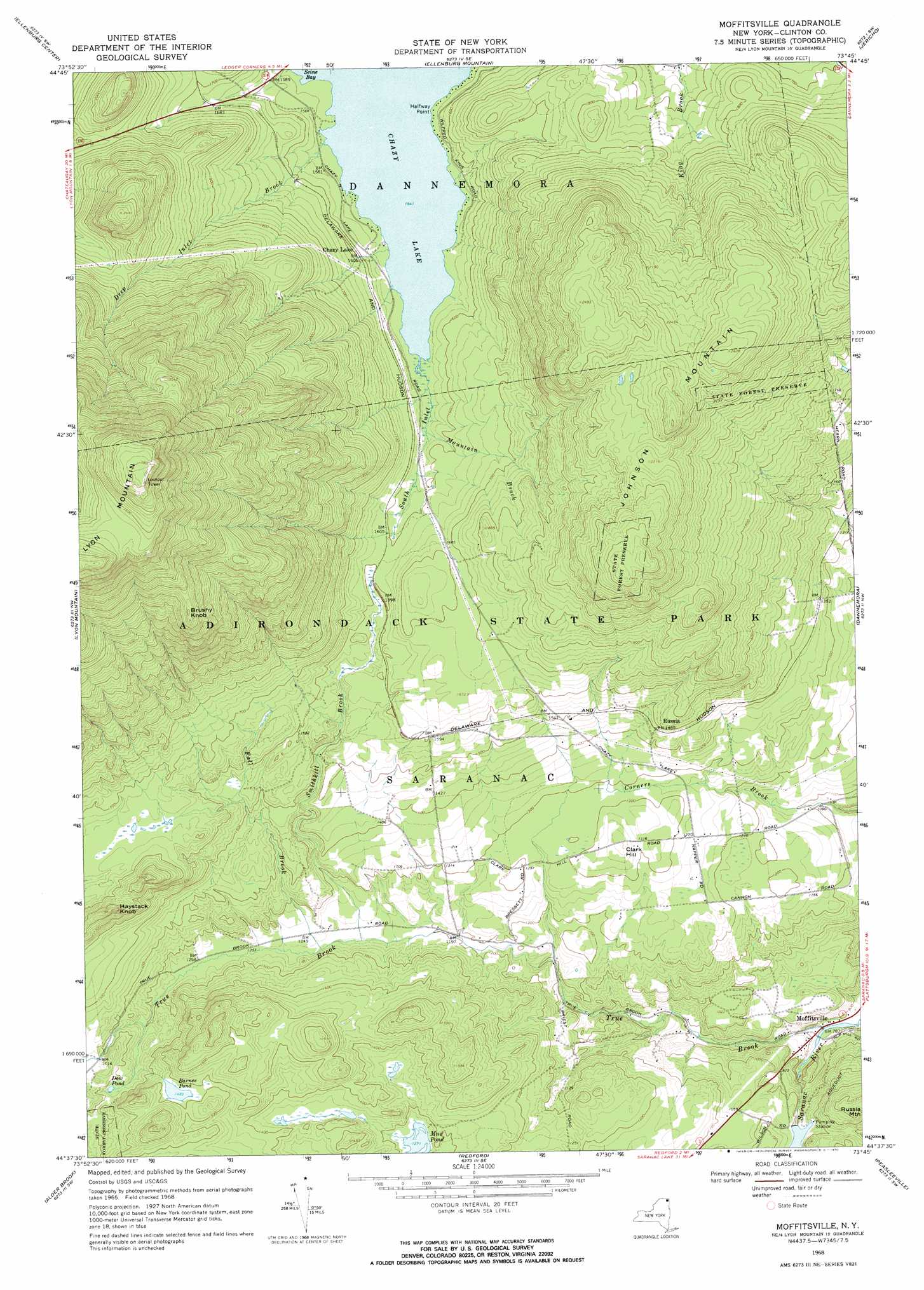
Moffitsville Topo Map New York
To zoom in, hover over the map of Moffitsville
USGS Topo Quad 44073f7 - 1:24,000 scale
| Topo Map Name: | Moffitsville |
| USGS Topo Quad ID: | 44073f7 |
| Print Size: | ca. 21 1/4" wide x 27" high |
| Southeast Coordinates: | 44.625° N latitude / 73.75° W longitude |
| Map Center Coordinates: | 44.6875° N latitude / 73.8125° W longitude |
| U.S. State: | NY |
| Filename: | o44073f7.jpg |
| Download Map JPG Image: | Moffitsville topo map 1:24,000 scale |
| Map Type: | Topographic |
| Topo Series: | 7.5´ |
| Map Scale: | 1:24,000 |
| Source of Map Images: | United States Geological Survey (USGS) |
| Alternate Map Versions: |
Moffitsville NY 1968, updated 1970 Download PDF Buy paper map Moffitsville NY 2010 Download PDF Buy paper map Moffitsville NY 2013 Download PDF Buy paper map Moffitsville NY 2016 Download PDF Buy paper map |
1:24,000 Topo Quads surrounding Moffitsville
Chateaugay |
Churubusco |
Ellenburg Depot |
Altona |
Mooers |
Brainardsville |
Ellenburg Center |
Ellenburg Mountain |
Jericho |
West Chazy |
Ragged Lake |
Lyon Mountain |
Moffitsville |
Dannemora |
Morrisonville |
Loon Lake |
Alder Brook |
Redford |
Peasleeville |
Peru |
Bloomingdale |
Wilmington |
Clintonville |
> Back to 44073e1 at 1:100,000 scale
> Back to 44072a1 at 1:250,000 scale
> Back to U.S. Topo Maps home
Moffitsville topo map: Gazetteer
Moffitsville: Capes
Halfway Point elevation 478m 1568′Moffitsville: Lakes
Barnes Pond elevation 452m 1482′Chazy Lake elevation 470m 1541′
Dow Pond elevation 417m 1368′
Mud Pond elevation 387m 1269′
Moffitsville: Populated Places
Moffitsville elevation 238m 780′Russia elevation 453m 1486′
Moffitsville: Streams
Deep Inlet Brook elevation 470m 1541′Fall Brook elevation 376m 1233′
Mountain Brook elevation 473m 1551′
Smithkill Brook elevation 372m 1220′
South Inlet elevation 470m 1541′
True Brook elevation 238m 780′
Moffitsville: Summits
Brushy Knob elevation 884m 2900′Clark Hill elevation 419m 1374′
Haystack Knob elevation 574m 1883′
Johnson Mountain elevation 755m 2477′
Lyon Mountain elevation 1167m 3828′
Moffitsville digital topo map on disk
Buy this Moffitsville topo map showing relief, roads, GPS coordinates and other geographical features, as a high-resolution digital map file on DVD:
New York, Vermont, Connecticut & Western Massachusetts
Buy digital topo maps: New York, Vermont, Connecticut & Western Massachusetts