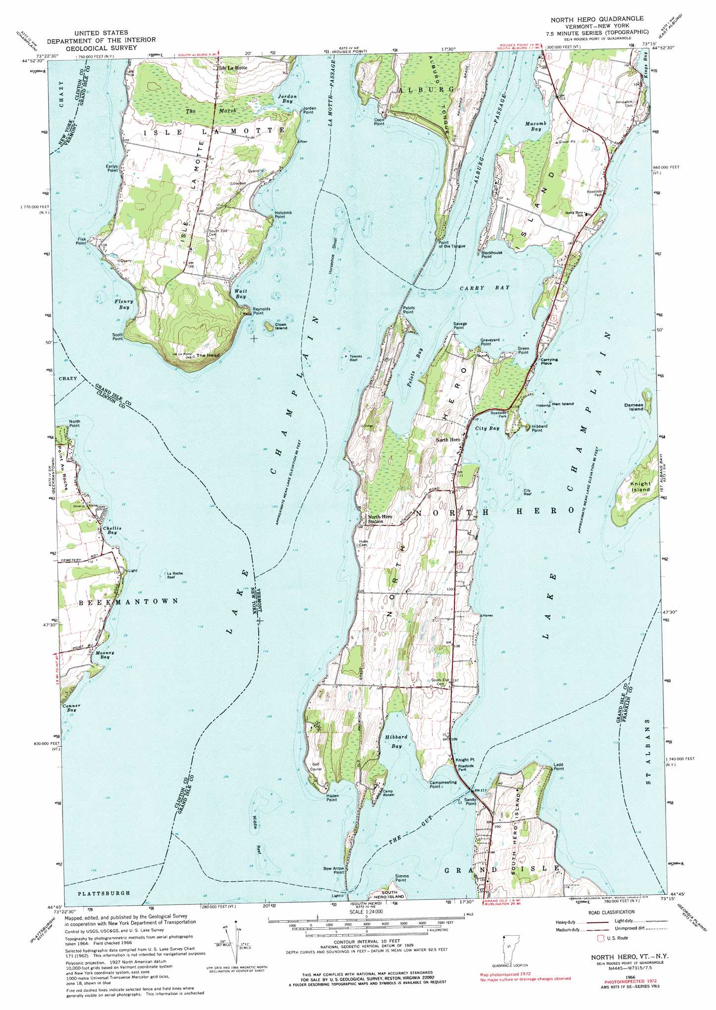
North Hero Topo Map Vermont
To zoom in, hover over the map of North Hero
USGS Topo Quad 44073g3 - 1:24,000 scale
| Topo Map Name: | North Hero |
| USGS Topo Quad ID: | 44073g3 |
| Print Size: | ca. 21 1/4" wide x 27" high |
| Southeast Coordinates: | 44.75° N latitude / 73.25° W longitude |
| Map Center Coordinates: | 44.8125° N latitude / 73.3125° W longitude |
| U.S. States: | VT, NY |
| Filename: | o44073g3.jpg |
| Download Map JPG Image: | North Hero topo map 1:24,000 scale |
| Map Type: | Topographic |
| Topo Series: | 7.5´ |
| Map Scale: | 1:24,000 |
| Source of Map Images: | United States Geological Survey (USGS) |
| Alternate Map Versions: |
North Hero VT 1966, updated 1968 Download PDF Buy paper map North Hero VT 1966, updated 1976 Download PDF Buy paper map North Hero VT 1966, updated 1976 Download PDF Buy paper map North Hero VT 2011 Download PDF Buy paper map North Hero VT 2012 Download PDF Buy paper map North Hero VT 2015 Download PDF Buy paper map |
1:24,000 Topo Quads surrounding North Hero
Mooers |
Champlain |
Rouses Point |
East Alburg |
Highgate Center |
West Chazy |
Beekmantown |
North Hero |
Saint Albans Bay |
Saint Albans |
Morrisonville |
Plattsburgh |
South Hero |
Georgia Plains |
Milton |
Peru |
Keeseville |
Colchester Point |
Colchester |
Essex Center |
> Back to 44073e1 at 1:100,000 scale
> Back to 44072a1 at 1:250,000 scale
> Back to U.S. Topo Maps home
North Hero topo map: Gazetteer
North Hero: Airports
Northern Lights Airport elevation 40m 131′North Hero: Bars
City Reef elevation 29m 95′Horseshoe Shoal elevation 29m 95′
La Roche Reef elevation 29m 95′
Middle Reef elevation 29m 95′
Townes Reef elevation 29m 95′
North Hero: Bays
Carry Bay elevation 29m 95′Chellis Bay elevation 29m 95′
City Bay elevation 29m 95′
Conner Bay elevation 29m 95′
Fleury Bay elevation 29m 95′
Hibbard Bay elevation 29m 95′
Jordan Bay elevation 29m 95′
Kings Bay elevation 29m 95′
Mooney Bay elevation 29m 95′
Pelots Bay elevation 29m 95′
Wait Bay elevation 29m 95′
North Hero: Capes
Blockhouse Point elevation 30m 98′Bow Arrow Point elevation 30m 98′
Campmeeting Point elevation 29m 95′
Coon Point elevation 30m 98′
Earlys Point elevation 32m 104′
Fisk Point elevation 31m 101′
Graveyard Point elevation 29m 95′
Green Point elevation 30m 98′
Hazen Point elevation 29m 95′
Hibbard Point elevation 38m 124′
Holcomb Point elevation 29m 95′
Jordan Point elevation 29m 95′
Knight Point elevation 34m 111′
Ladd Point elevation 30m 98′
Monty Point elevation 33m 108′
North Point elevation 30m 98′
Pelots Point elevation 32m 104′
Point Au Roche elevation 32m 104′
Point of the Tongue elevation 32m 104′
Reynolds Point elevation 29m 95′
Sandy Point elevation 34m 111′
Savage Point elevation 29m 95′
Scott Point elevation 32m 104′
Simms Point elevation 29m 95′
North Hero: Guts
The Gut elevation 29m 95′North Hero: Islands
Cloak Island elevation 29m 95′Dameas Island elevation 32m 104′
Hen Island elevation 29m 95′
Isle la Motte elevation 32m 104′
Knight Island elevation 38m 124′
North Hero Island elevation 34m 111′
North Hero: Parks
Knight Point State Park elevation 36m 118′North Hero: Populated Places
North Hero elevation 29m 95′North Hero: Summits
The Head elevation 74m 242′North Hero: Swamps
The Marsh elevation 30m 98′North Hero digital topo map on disk
Buy this North Hero topo map showing relief, roads, GPS coordinates and other geographical features, as a high-resolution digital map file on DVD:
New York, Vermont, Connecticut & Western Massachusetts
Buy digital topo maps: New York, Vermont, Connecticut & Western Massachusetts