Beekmantown Topo Map New York
To zoom in, hover over the map of Beekmantown
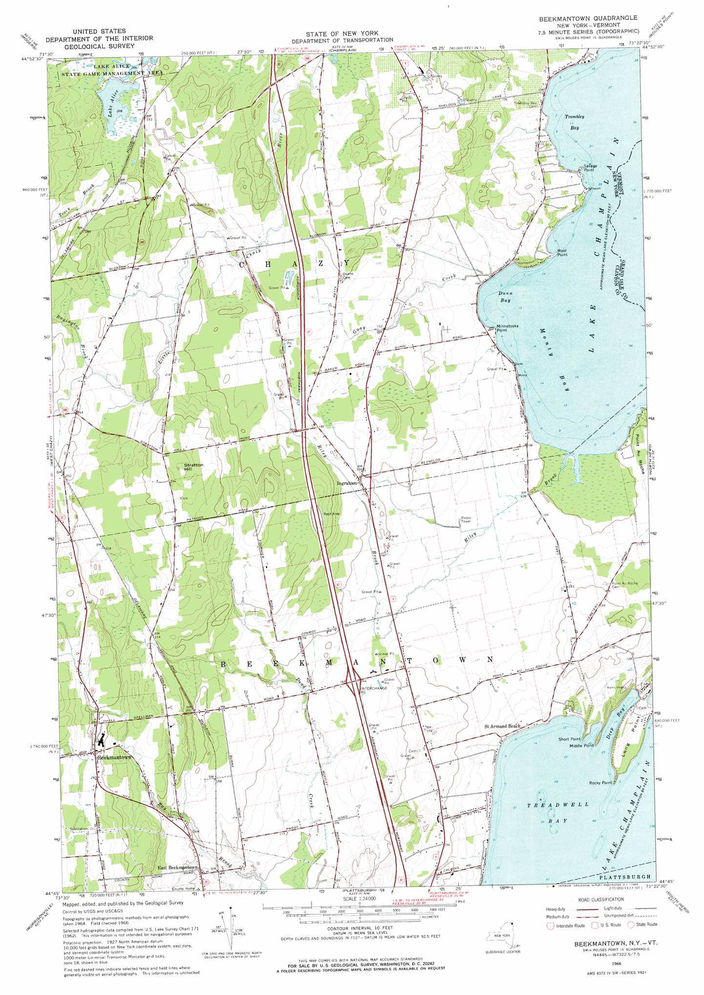
USGS Topo Quad 44073g4 - 1:24,000 scale
| Topo Map Name: | Beekmantown |
| USGS Topo Quad ID: | 44073g4 |
| Print Size: | ca. 21 1/4" wide x 27" high |
| Southeast Coordinates: | 44.75° N latitude / 73.375° W longitude |
| Map Center Coordinates: | 44.8125° N latitude / 73.4375° W longitude |
| U.S. States: | NY, VT |
| Filename: | o44073g4.jpg |
| Download Map JPG Image: | Beekmantown topo map 1:24,000 scale |
| Map Type: | Topographic |
| Topo Series: | 7.5´ |
| Map Scale: | 1:24,000 |
| Source of Map Images: | United States Geological Survey (USGS) |
| Alternate Map Versions: |
Beekmantown NY 1966, updated 1968 Download PDF Buy paper map Beekmantown NY 1966, updated 1968 Download PDF Buy paper map Beekmantown NY 2011 Download PDF Buy paper map Beekmantown NY 2013 Download PDF Buy paper map Beekmantown NY 2016 Download PDF Buy paper map |
1:24,000 Topo Quads surrounding Beekmantown
Altona |
Mooers |
Champlain |
Rouses Point |
East Alburg |
Jericho |
West Chazy |
Beekmantown |
North Hero |
Saint Albans Bay |
Dannemora |
Morrisonville |
Plattsburgh |
South Hero |
Georgia Plains |
Peasleeville |
Peru |
Keeseville |
Colchester Point |
Colchester |
> Back to 44073e1 at 1:100,000 scale
> Back to 44072a1 at 1:250,000 scale
> Back to U.S. Topo Maps home
Beekmantown topo map: Gazetteer
Beekmantown: Bays
Deep Bay elevation 29m 95′Dunn Bay elevation 29m 95′
Middle Bay elevation 29m 95′
Monty Bay elevation 29m 95′
Treadwell Bay elevation 29m 95′
Trombley Bay elevation 29m 95′
Beekmantown: Capes
Long Point elevation 33m 108′Middle Point elevation 30m 98′
Minnetoska Point elevation 31m 101′
Rocky Point elevation 30m 98′
Savage Point elevation 29m 95′
Short Point elevation 30m 98′
Wool Point elevation 30m 98′
Beekmantown: Crossings
Interchange 40 elevation 41m 134′Beekmantown: Lakes
Lake Alice elevation 64m 209′Beekmantown: Populated Places
Beekmantown elevation 77m 252′East Beekmantown elevation 43m 141′
Ingraham elevation 50m 164′
Point Au Roche elevation 50m 164′
Beekmantown: Streams
Boyington Brook elevation 67m 219′Guay Creek elevation 29m 95′
Riley Brook elevation 29m 95′
Beekmantown: Summits
Stratton Hill elevation 89m 291′Beekmantown digital topo map on disk
Buy this Beekmantown topo map showing relief, roads, GPS coordinates and other geographical features, as a high-resolution digital map file on DVD:
New York, Vermont, Connecticut & Western Massachusetts
Buy digital topo maps: New York, Vermont, Connecticut & Western Massachusetts