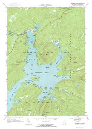
Cranberry Lake Topo Map New York
To zoom in, hover over the map of Cranberry Lake
USGS Topo Quad 44074b7 - 1:24,000 scale
| Topo Map Name: | Cranberry Lake |
| USGS Topo Quad ID: | 44074b7 |
| Print Size: | ca. 21 1/4" wide x 27" high |
| Southeast Coordinates: | 44.125° N latitude / 74.75° W longitude |
| Map Center Coordinates: | 44.1875° N latitude / 74.8125° W longitude |
| U.S. State: | NY |
| Filename: | o44074b7.jpg |
| Download Map JPG Image: | Cranberry Lake topo map 1:24,000 scale |
| Map Type: | Topographic |
| Topo Series: | 7.5´ |
| Map Scale: | 1:24,000 |
| Source of Map Images: | United States Geological Survey (USGS) |
| Alternate Map Versions: |
Cranberry Lake NY 1968, updated 1971 Download PDF Buy paper map Cranberry Lake NY 1968, updated 1971 Download PDF Buy paper map Cranberry Lake NY 1999, updated 2001 Download PDF Buy paper map Cranberry Lake NY 2010 Download PDF Buy paper map Cranberry Lake NY 2013 Download PDF Buy paper map Cranberry Lake NY 2016 Download PDF Buy paper map |
1:24,000 Topo Quads surrounding Cranberry Lake
> Back to 44074a1 at 1:100,000 scale
> Back to 44074a1 at 1:250,000 scale
> Back to U.S. Topo Maps home
Cranberry Lake topo map: Gazetteer
Cranberry Lake: Bays
Bear Mountain Flow elevation 453m 1486′Black Duck Hole elevation 453m 1486′
Brandy Brook Flow elevation 453m 1486′
Chair Rock Flow elevation 453m 1486′
Chipmunk Bay elevation 453m 1486′
East Inlet elevation 453m 1486′
Green Bay elevation 453m 1486′
Hedgehog Bay elevation 453m 1486′
La Fountain Bay elevation 453m 1486′
Matilda Bay elevation 453m 1486′
Shanty Rock Flow elevation 453m 1486′
South Bay elevation 453m 1486′
South Flow elevation 453m 1486′
Thompson Bay elevation 453m 1486′
West Flow elevation 453m 1486′
Witchhobble Bay elevation 453m 1486′
Cranberry Lake: Capes
Arnolds Point elevation 456m 1496′Barber Point elevation 460m 1509′
Chair Rock Point elevation 458m 1502′
Coles Point elevation 453m 1486′
Deremo Point elevation 453m 1486′
Elephant Rock elevation 453m 1486′
Flat Rock elevation 458m 1502′
Green Point elevation 453m 1486′
Janacks Point elevation 455m 1492′
Joes Point elevation 458m 1502′
Lansings Point elevation 455m 1492′
Lightning Point elevation 453m 1486′
Long Point elevation 456m 1496′
Union Point elevation 459m 1505′
Witchhobble Point elevation 453m 1486′
Cranberry Lake: Islands
Albert Island elevation 458m 1502′Barber Island elevation 457m 1499′
Big Bog Island elevation 453m 1486′
Birch Island elevation 453m 1486′
Buck Island elevation 475m 1558′
Catamount Island elevation 459m 1505′
Chair Rock Island elevation 453m 1486′
Dog Island elevation 453m 1486′
Eagle Island elevation 453m 1486′
Gull Rock elevation 453m 1486′
Hawks Island elevation 453m 1486′
Joe Indian Island elevation 463m 1519′
Kimball Island elevation 455m 1492′
Matilda Island elevation 453m 1486′
Norway Island elevation 453m 1486′
Pine Island elevation 453m 1486′
Sears Islands elevation 453m 1486′
Cranberry Lake: Lakes
Curtis Pond elevation 559m 1833′Dillon Pond elevation 453m 1486′
Grass Pond elevation 447m 1466′
Hedgehog Pond elevation 514m 1686′
Indian Mountain Pond elevation 534m 1751′
Lost Pond elevation 467m 1532′
Silver Lake elevation 452m 1482′
Spectacle Pond elevation 516m 1692′
Toad Pond elevation 505m 1656′
Cranberry Lake: Populated Places
Brandy Brook elevation 449m 1473′Cranberry Lake elevation 454m 1489′
Cranberry Lake: Reservoirs
Cranberry Lake elevation 453m 1486′Cranberry Lake: Streams
Brandy Brook elevation 453m 1486′Chair Rock Creek elevation 453m 1486′
East Creek elevation 456m 1496′
Peavine Creek elevation 433m 1420′
Sixmile Creek elevation 453m 1486′
Sucker Brook elevation 453m 1486′
Cranberry Lake: Summits
Bear Mountain elevation 653m 2142′Burnt Rock elevation 460m 1509′
East Mountain elevation 712m 2335′
Hedgehog Mountain elevation 630m 2066′
Indian Mountain elevation 679m 2227′
Cranberry Lake: Swamps
Bear Mountain Swamp elevation 454m 1489′Cranberry Lake digital topo map on disk
Buy this Cranberry Lake topo map showing relief, roads, GPS coordinates and other geographical features, as a high-resolution digital map file on DVD:
New York, Vermont, Connecticut & Western Massachusetts
Buy digital topo maps: New York, Vermont, Connecticut & Western Massachusetts


