Carry Falls Reservoir Topo Map New York
To zoom in, hover over the map of Carry Falls Reservoir
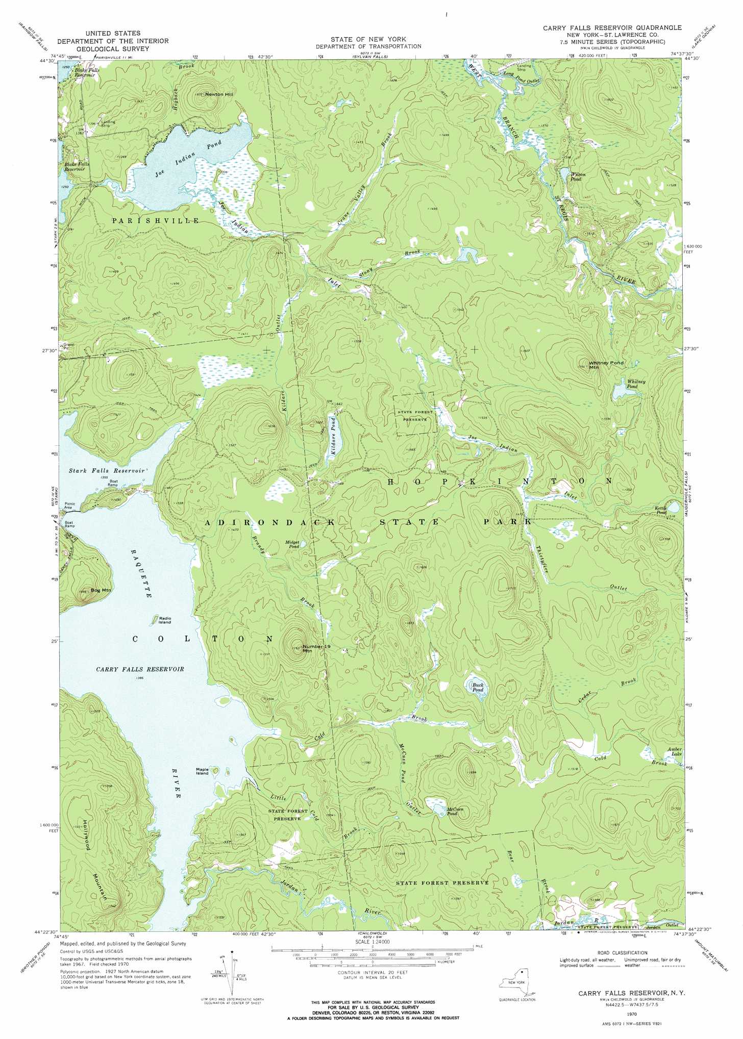
USGS Topo Quad 44074d6 - 1:24,000 scale
| Topo Map Name: | Carry Falls Reservoir |
| USGS Topo Quad ID: | 44074d6 |
| Print Size: | ca. 21 1/4" wide x 27" high |
| Southeast Coordinates: | 44.375° N latitude / 74.625° W longitude |
| Map Center Coordinates: | 44.4375° N latitude / 74.6875° W longitude |
| U.S. State: | NY |
| Filename: | o44074d6.jpg |
| Download Map JPG Image: | Carry Falls Reservoir topo map 1:24,000 scale |
| Map Type: | Topographic |
| Topo Series: | 7.5´ |
| Map Scale: | 1:24,000 |
| Source of Map Images: | United States Geological Survey (USGS) |
| Alternate Map Versions: |
Carry Falls Reservoir NY 1970, updated 1972 Download PDF Buy paper map Carry Falls Reservoir NY 2010 Download PDF Buy paper map Carry Falls Reservoir NY 2013 Download PDF Buy paper map Carry Falls Reservoir NY 2016 Download PDF Buy paper map |
1:24,000 Topo Quads surrounding Carry Falls Reservoir
Potsdam |
Parishville |
Nicholville |
Saint Regis Falls |
Santa Clara |
Colton |
Rainbow Falls |
Sylvan Falls |
Lake Ozonia |
Meno |
Albert Marsh |
Stark |
Carry Falls Reservoir |
Augerhole Falls |
|
Tooley Pond |
Brother Ponds |
Childwold |
Mount Matumbla |
|
Newton Falls |
Cranberry Lake |
Pierce Field |
> Back to 44074a1 at 1:100,000 scale
> Back to 44074a1 at 1:250,000 scale
> Back to U.S. Topo Maps home
Carry Falls Reservoir topo map: Gazetteer
Carry Falls Reservoir: Airports
Blake Falls Airport elevation 381m 1250′Carry Falls Reservoir: Channels
Jordan Outlet elevation 457m 1499′Carry Falls Reservoir: Islands
Maple Island elevation 428m 1404′Radio Island elevation 428m 1404′
Carry Falls Reservoir: Lakes
Buck Pond elevation 468m 1535′Joe Indian Pond elevation 394m 1292′
Kettle Pond elevation 459m 1505′
Kildare Pond elevation 436m 1430′
McCuen Pond elevation 456m 1496′
Midget Pond elevation 444m 1456′
Whitney Pond elevation 460m 1509′
Wilson Pond elevation 425m 1394′
Carry Falls Reservoir: Populated Places
Hollywood (historical) elevation 422m 1384′Carry Falls Reservoir: Reservoirs
Carry Falls Reservoir elevation 414m 1358′Carry Falls Reservoir: Streams
Brandy Brook elevation 423m 1387′Cedar Brook elevation 455m 1492′
Cold Brook elevation 422m 1384′
Crane Valley Brook elevation 396m 1299′
Joe Indian Inlet elevation 394m 1292′
Jordan River elevation 422m 1384′
Kildare Outlet elevation 402m 1318′
Little Cold Brook elevation 423m 1387′
Long Pond Outlet elevation 402m 1318′
McCuen Pond Outlet elevation 443m 1453′
Stony Brook elevation 402m 1318′
Thirtyfive Outlet elevation 448m 1469′
Carry Falls Reservoir: Summits
Bog Mountain elevation 501m 1643′Hollywood Mountain elevation 531m 1742′
Newton Hill elevation 458m 1502′
Number 19 Mountain elevation 538m 1765′
Whitney Pond Mountain elevation 523m 1715′
Carry Falls Reservoir digital topo map on disk
Buy this Carry Falls Reservoir topo map showing relief, roads, GPS coordinates and other geographical features, as a high-resolution digital map file on DVD:
New York, Vermont, Connecticut & Western Massachusetts
Buy digital topo maps: New York, Vermont, Connecticut & Western Massachusetts