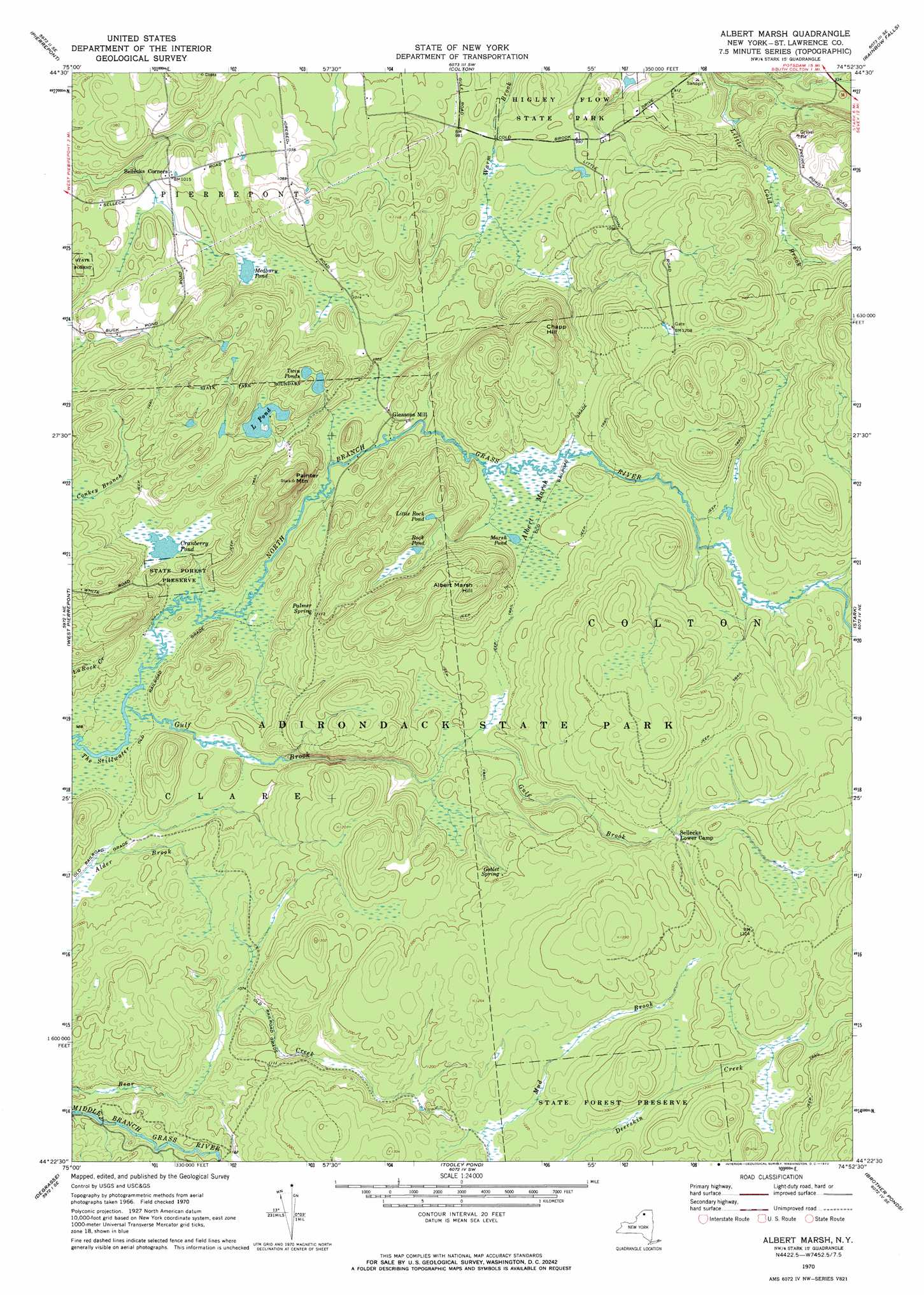
Albert Marsh Topo Map New York
To zoom in, hover over the map of Albert Marsh
USGS Topo Quad 44074d8 - 1:24,000 scale
| Topo Map Name: | Albert Marsh |
| USGS Topo Quad ID: | 44074d8 |
| Print Size: | ca. 21 1/4" wide x 27" high |
| Southeast Coordinates: | 44.375° N latitude / 74.875° W longitude |
| Map Center Coordinates: | 44.4375° N latitude / 74.9375° W longitude |
| U.S. State: | NY |
| Filename: | o44074d8.jpg |
| Download Map JPG Image: | Albert Marsh topo map 1:24,000 scale |
| Map Type: | Topographic |
| Topo Series: | 7.5´ |
| Map Scale: | 1:24,000 |
| Source of Map Images: | United States Geological Survey (USGS) |
| Alternate Map Versions: |
Albert Marsh NY 1970, updated 1972 Download PDF Buy paper map Albert Marsh NY 2010 Download PDF Buy paper map Albert Marsh NY 2013 Download PDF Buy paper map Albert Marsh NY 2016 Download PDF Buy paper map |
1:24,000 Topo Quads surrounding Albert Marsh
Morley |
West Potsdam |
Potsdam |
Parishville |
Nicholville |
Canton |
Pierrepont |
Colton |
Rainbow Falls |
Sylvan Falls |
Hermon |
West Pierrepont |
Albert Marsh |
Stark |
Carry Falls Reservoir |
South Edwards |
Degrasse |
Tooley Pond |
Brother Ponds |
Childwold |
Fine |
Oswegatchie |
Newton Falls |
Cranberry Lake |
> Back to 44074a1 at 1:100,000 scale
> Back to 44074a1 at 1:250,000 scale
> Back to U.S. Topo Maps home
Albert Marsh topo map: Gazetteer
Albert Marsh: Lakes
Cranberry Pond elevation 308m 1010′L Pond elevation 326m 1069′
Little Rock Pond elevation 369m 1210′
Marsh Pond elevation 334m 1095′
Rock Pond elevation 352m 1154′
Twin Ponds elevation 334m 1095′
Albert Marsh: Parks
Higley Flow State Park elevation 291m 954′Albert Marsh: Populated Places
Gleasons Mill elevation 304m 997′Albert Marsh: Springs
Goblet Spring elevation 356m 1167′Palmer Spring elevation 338m 1108′
Albert Marsh: Streams
Gulf Brook elevation 286m 938′Albert Marsh: Summits
Albert Marsh Hill elevation 422m 1384′Chapp Hill elevation 408m 1338′
Painter Mountain elevation 415m 1361′
Albert Marsh: Swamps
Albert Marsh elevation 333m 1092′Albert Marsh digital topo map on disk
Buy this Albert Marsh topo map showing relief, roads, GPS coordinates and other geographical features, as a high-resolution digital map file on DVD:
New York, Vermont, Connecticut & Western Massachusetts
Buy digital topo maps: New York, Vermont, Connecticut & Western Massachusetts