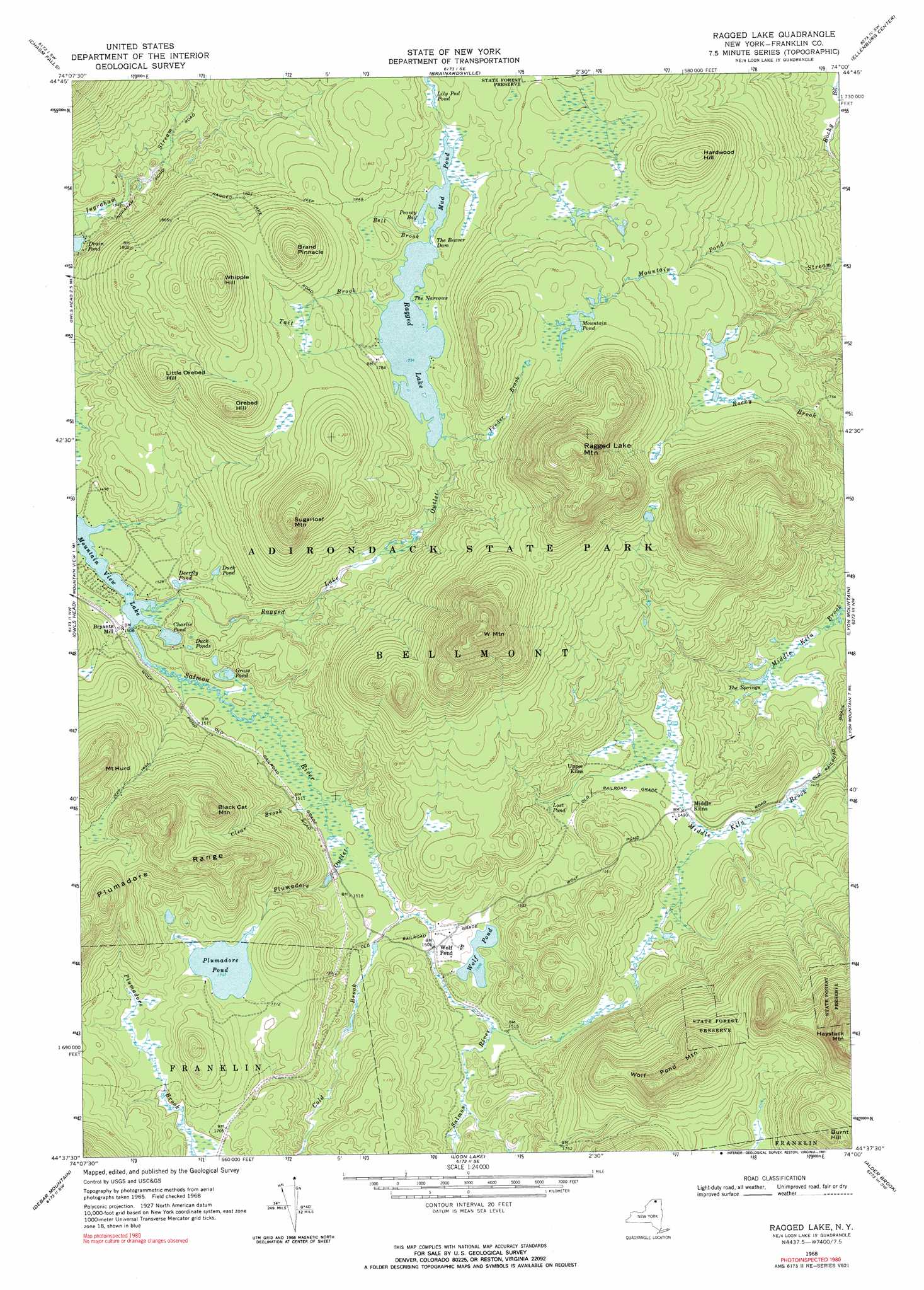
Ragged Lake Topo Map New York
To zoom in, hover over the map of Ragged Lake
USGS Topo Quad 44074f1 - 1:24,000 scale
| Topo Map Name: | Ragged Lake |
| USGS Topo Quad ID: | 44074f1 |
| Print Size: | ca. 21 1/4" wide x 27" high |
| Southeast Coordinates: | 44.625° N latitude / 74° W longitude |
| Map Center Coordinates: | 44.6875° N latitude / 74.0625° W longitude |
| U.S. State: | NY |
| Filename: | o44074f1.jpg |
| Download Map JPG Image: | Ragged Lake topo map 1:24,000 scale |
| Map Type: | Topographic |
| Topo Series: | 7.5´ |
| Map Scale: | 1:24,000 |
| Source of Map Images: | United States Geological Survey (USGS) |
| Alternate Map Versions: |
Ragged Lake NY 1968, updated 1970 Download PDF Buy paper map Ragged Lake NY 1968, updated 1991 Download PDF Buy paper map Ragged Lake NY 2010 Download PDF Buy paper map Ragged Lake NY 2013 Download PDF Buy paper map Ragged Lake NY 2016 Download PDF Buy paper map |
1:24,000 Topo Quads surrounding Ragged Lake
Constable |
Burke |
Chateaugay |
Churubusco |
Ellenburg Depot |
Malone |
Chasm Falls |
Brainardsville |
Ellenburg Center |
Ellenburg Mountain |
Lake Titus |
Owls Head |
Ragged Lake |
Lyon Mountain |
Moffitsville |
Meacham Lake |
Debar Mountain |
Loon Lake |
Alder Brook |
Redford |
Saint Regis Mountain |
Bloomingdale |
Wilmington |
> Back to 44074e1 at 1:100,000 scale
> Back to 44074a1 at 1:250,000 scale
> Back to U.S. Topo Maps home
Ragged Lake topo map: Gazetteer
Ragged Lake: Bays
Peavey Bay elevation 529m 1735′Ragged Lake: Channels
The Narrows elevation 528m 1732′Ragged Lake: Dams
The Beaver Dam elevation 530m 1738′Ragged Lake: Lakes
Charlie Pond elevation 454m 1489′Deerfly Pond elevation 461m 1512′
Drain Pond elevation 472m 1548′
Duck Pond elevation 475m 1558′
Duck Ponds elevation 468m 1535′
Grass Pond elevation 455m 1492′
Lily Pod Pond elevation 532m 1745′
Lost Pond elevation 463m 1519′
Mountain Pond elevation 594m 1948′
Mud Pond elevation 529m 1735′
Plumadore Pond elevation 520m 1706′
Ragged Lake elevation 528m 1732′
The Springs elevation 402m 1318′
Wolf Pond elevation 460m 1509′
Ragged Lake: Populated Places
Bryants Mill elevation 458m 1502′Wolf Pond elevation 459m 1505′
Ragged Lake: Ridges
Plumadore Range elevation 645m 2116′Ragged Lake: Streams
Bell Brook elevation 529m 1735′Clear Brook elevation 453m 1486′
Cold Brook elevation 456m 1496′
Fender Brook elevation 529m 1735′
Plumadore Outlet elevation 454m 1489′
Ragged Lake Outlet elevation 455m 1492′
Tait Brook elevation 528m 1732′
Ragged Lake: Summits
Black Cat Mountain elevation 649m 2129′Brand Pinnacle elevation 662m 2171′
Burnt Hill elevation 726m 2381′
Hardwood Hill elevation 629m 2063′
Haystack Mountain elevation 882m 2893′
Little Orebed Hill elevation 591m 1938′
Mount Hurd elevation 662m 2171′
Orebed Hill elevation 659m 2162′
Ragged Lake Mountain elevation 832m 2729′
Sugarloaf Mountain elevation 697m 2286′
W Mountain elevation 825m 2706′
Whipple Hill elevation 678m 2224′
Wolf Pond Mountain elevation 732m 2401′
Ragged Lake digital topo map on disk
Buy this Ragged Lake topo map showing relief, roads, GPS coordinates and other geographical features, as a high-resolution digital map file on DVD:
New York, Vermont, Connecticut & Western Massachusetts
Buy digital topo maps: New York, Vermont, Connecticut & Western Massachusetts