Gouverneur Topo Map New York
To zoom in, hover over the map of Gouverneur
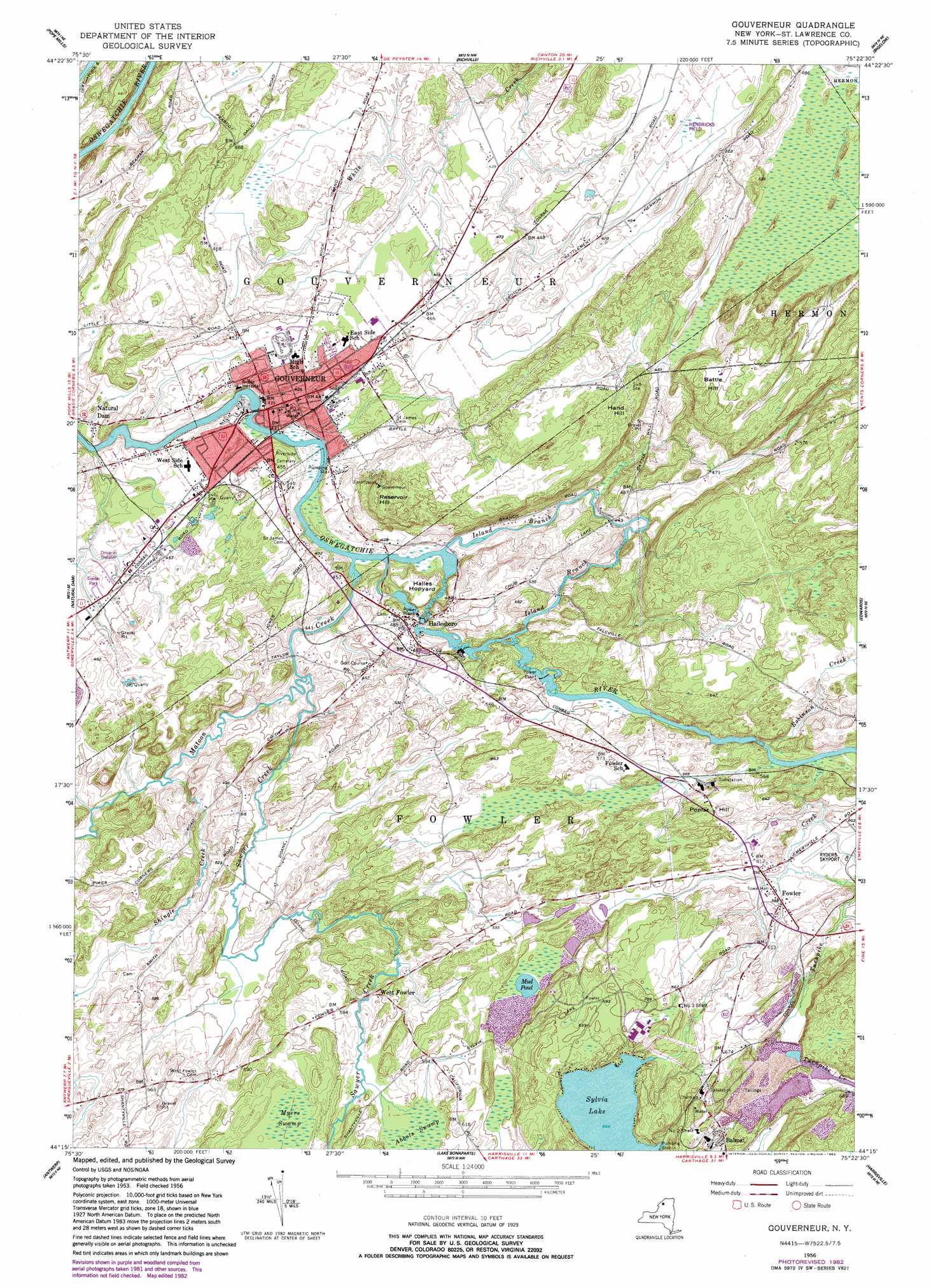
USGS Topo Quad 44075c4 - 1:24,000 scale
| Topo Map Name: | Gouverneur |
| USGS Topo Quad ID: | 44075c4 |
| Print Size: | ca. 21 1/4" wide x 27" high |
| Southeast Coordinates: | 44.25° N latitude / 75.375° W longitude |
| Map Center Coordinates: | 44.3125° N latitude / 75.4375° W longitude |
| U.S. State: | NY |
| Filename: | o44075c4.jpg |
| Download Map JPG Image: | Gouverneur topo map 1:24,000 scale |
| Map Type: | Topographic |
| Topo Series: | 7.5´ |
| Map Scale: | 1:24,000 |
| Source of Map Images: | United States Geological Survey (USGS) |
| Alternate Map Versions: |
Gouverneur NY 1956, updated 1958 Download PDF Buy paper map Gouverneur NY 1956, updated 1974 Download PDF Buy paper map Gouverneur NY 1982, updated 1983 Download PDF Buy paper map Gouverneur NY 2011 Download PDF Buy paper map Gouverneur NY 2013 Download PDF Buy paper map Gouverneur NY 2016 Download PDF Buy paper map |
1:24,000 Topo Quads surrounding Gouverneur
Morristown |
Edwardsville |
Heuvelton |
Rensselaer Falls |
Canton |
Hammond |
Pope Mills |
Richville |
Bigelow |
Hermon |
Muskellunge Lake |
Natural Dam |
Gouverneur |
Edwards |
South Edwards |
Philadelphia |
Antwerp |
Lake Bonaparte |
Harrisville |
Fine |
Deferiet |
North Wilna |
Natural Bridge |
Remington Corners |
Oswegatchie Sw |
> Back to 44075a1 at 1:100,000 scale
> Back to 44074a1 at 1:250,000 scale
> Back to U.S. Topo Maps home
Gouverneur topo map: Gazetteer
Gouverneur: Airports
Hendricks Field elevation 145m 475′Ryders Skyport Airport elevation 177m 580′
Gouverneur: Lakes
Mud Pond elevation 181m 593′Sylvia Lake elevation 199m 652′
Gouverneur: Mines
Number 2 Shaft elevation 213m 698′Number 3 Shaft elevation 209m 685′
Gouverneur: Populated Places
Fowler elevation 180m 590′Gouverneur elevation 134m 439′
Hailesboro elevation 150m 492′
West Fowler elevation 178m 583′
Gouverneur: Streams
Island Branch elevation 122m 400′Matoon Creek elevation 122m 400′
Robinson Creek elevation 166m 544′
Sawyer Creek elevation 123m 403′
Shingle Creek elevation 125m 410′
Turnpike Creek elevation 168m 551′
Gouverneur: Summits
Battle Hill elevation 183m 600′Hailes Hopyard elevation 142m 465′
Hand Hill elevation 182m 597′
Poplar Hill elevation 205m 672′
Reservoir Hill elevation 184m 603′
Gouverneur: Swamps
Myers Swamp elevation 184m 603′Gouverneur digital topo map on disk
Buy this Gouverneur topo map showing relief, roads, GPS coordinates and other geographical features, as a high-resolution digital map file on DVD:
New York, Vermont, Connecticut & Western Massachusetts
Buy digital topo maps: New York, Vermont, Connecticut & Western Massachusetts