Port Austin East Topo Map Michigan
To zoom in, hover over the map of Port Austin East
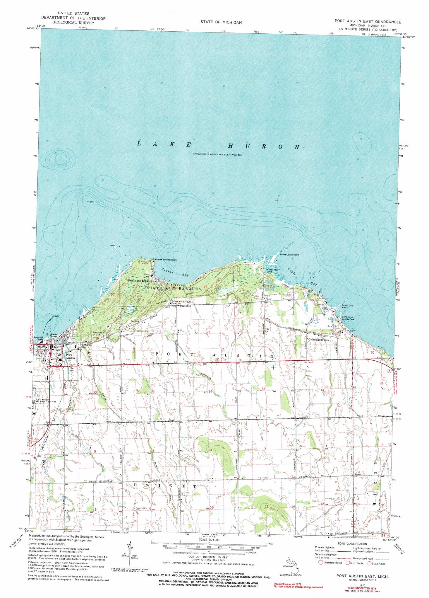
USGS Topo Quad 44082a8 - 1:24,000 scale
| Topo Map Name: | Port Austin East |
| USGS Topo Quad ID: | 44082a8 |
| Print Size: | ca. 21 1/4" wide x 27" high |
| Southeast Coordinates: | 44° N latitude / 82.875° W longitude |
| Map Center Coordinates: | 44.0625° N latitude / 82.9375° W longitude |
| U.S. State: | MI |
| Filename: | o44082a8.jpg |
| Download Map JPG Image: | Port Austin East topo map 1:24,000 scale |
| Map Type: | Topographic |
| Topo Series: | 7.5´ |
| Map Scale: | 1:24,000 |
| Source of Map Images: | United States Geological Survey (USGS) |
| Alternate Map Versions: |
Port Austin East MI 1970, updated 1973 Download PDF Buy paper map Port Austin East MI 1970, updated 1973 Download PDF Buy paper map Port Austin East MI 2011 Download PDF Buy paper map Port Austin East MI 2014 Download PDF Buy paper map Port Austin East MI 2016 Download PDF Buy paper map |
1:24,000 Topo Quads surrounding Port Austin East
Port Austin West |
Port Austin East |
Huron City |
||
Rush Lake |
Kinde West |
Kinde East |
Redman |
Port Hope |
Elkton |
Bad Axe West |
Bad Axe East |
Bad Axe Se |
Harbor Beach |
> Back to 44082a1 at 1:100,000 scale
> Back to 44082a1 at 1:250,000 scale
> Back to U.S. Topo Maps home
Port Austin East topo map: Gazetteer
Port Austin East: Bays
Alaska Bay elevation 177m 580′Eagle Bay elevation 177m 580′
Port Austin East: Canals
Baranski Drain elevation 207m 679′Dwight Drain elevation 189m 620′
Port Austin East: Capes
Burnt Cabin Point elevation 178m 583′Pointe aux Barques elevation 183m 600′
Port Austin East: Parks
Charles G Learned Historical Marker elevation 184m 603′Grindstone County Park elevation 178m 583′
Port Austin East: Populated Places
Grind Stone City elevation 183m 600′Pointe aux Barques elevation 180m 590′
Port Austin elevation 182m 597′
Port Austin East: Post Offices
Grind Stone City Post Office elevation 183m 600′Hellems Post Office (historical) elevation 194m 636′
Pointe Aux Baques Post Office (historical) elevation 180m 590′
Port Austin Post Office elevation 181m 593′
Port Austin East: Streams
Bird Creek elevation 178m 583′Grant Creek elevation 177m 580′
Port Austin East digital topo map on disk
Buy this Port Austin East topo map showing relief, roads, GPS coordinates and other geographical features, as a high-resolution digital map file on DVD:
 map DVD")