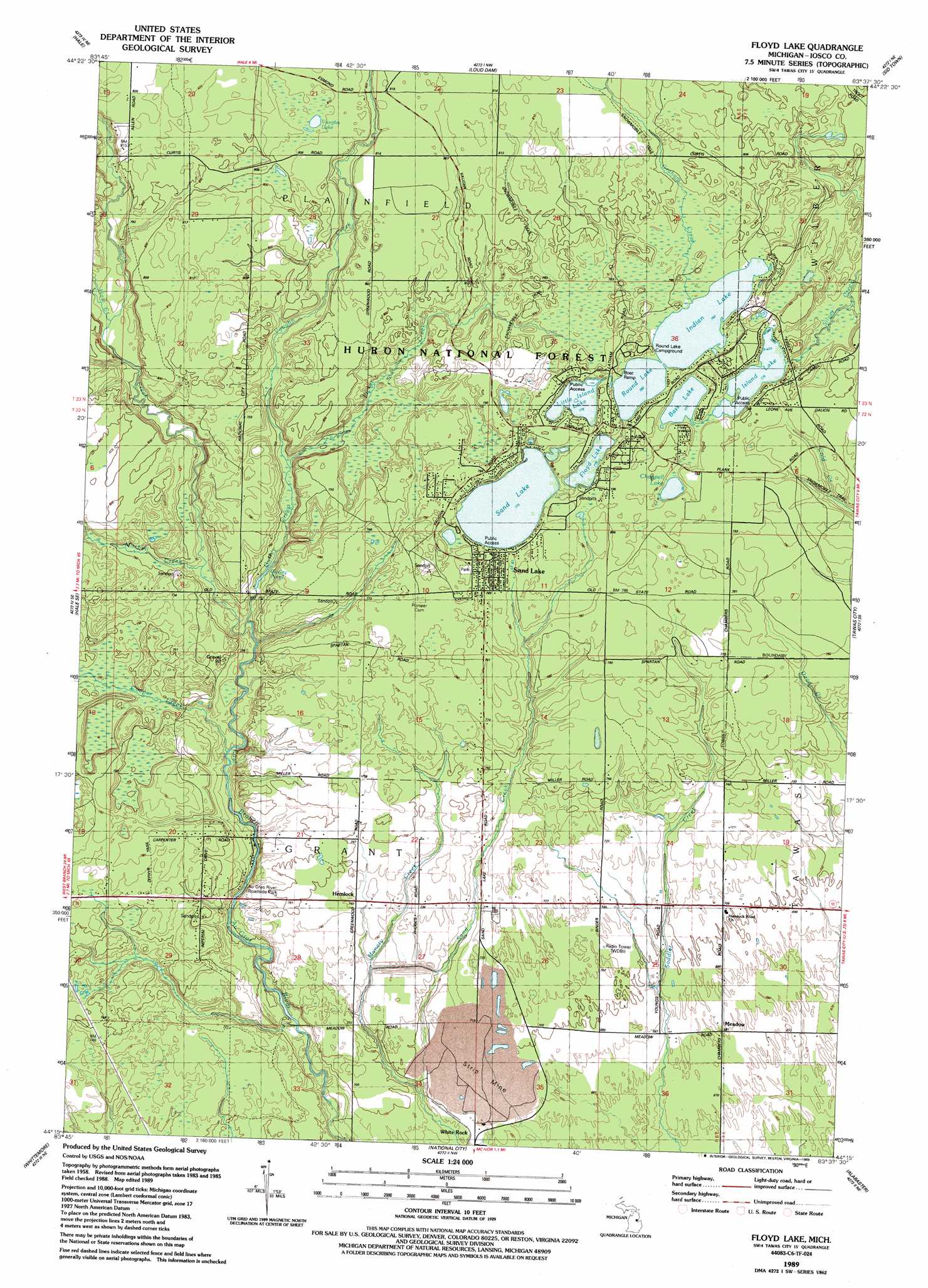
Floyd Lake Topo Map Michigan
To zoom in, hover over the map of Floyd Lake
USGS Topo Quad 44083c6 - 1:24,000 scale
| Topo Map Name: | Floyd Lake |
| USGS Topo Quad ID: | 44083c6 |
| Print Size: | ca. 21 1/4" wide x 27" high |
| Southeast Coordinates: | 44.25° N latitude / 83.625° W longitude |
| Map Center Coordinates: | 44.3125° N latitude / 83.6875° W longitude |
| U.S. State: | MI |
| Filename: | o44083c6.jpg |
| Download Map JPG Image: | Floyd Lake topo map 1:24,000 scale |
| Map Type: | Topographic |
| Topo Series: | 7.5´ |
| Map Scale: | 1:24,000 |
| Source of Map Images: | United States Geological Survey (USGS) |
| Alternate Map Versions: |
Floyd Lake MI 1989, updated 1989 Download PDF Buy paper map Floyd Lake MI 2012 Download PDF Buy paper map Floyd Lake MI 2014 Download PDF Buy paper map Floyd Lake MI 2016 Download PDF Buy paper map |
| FStopo: | US Forest Service topo Floyd Lake is available: Download FStopo PDF Download FStopo TIF |
1:24,000 Topo Quads surrounding Floyd Lake
Goodar |
Alcona Dam Pond |
Glennie |
Sprinkler Creek |
Mikado |
South Branch |
Hale |
Loud Dam |
Sid Town |
Foote Site Village |
Sage Lake |
Hale Se |
Floyd Lake |
Tawas City |
East Tawas |
Prescott |
Whittemore |
National City |
Alabaster |
|
Omer Sw |
Omer |
Au Gres |
Point Lookout |
Charity Island |
> Back to 44083a1 at 1:100,000 scale
> Back to 44082a1 at 1:250,000 scale
> Back to U.S. Topo Maps home
Floyd Lake topo map: Gazetteer
Floyd Lake: Lakes
Bass Lake elevation 237m 777′Chappell Lake elevation 241m 790′
Floyd Lake elevation 237m 777′
Guiley Pond elevation 220m 721′
Indian Lake elevation 238m 780′
Island Lake elevation 236m 774′
Little Island Lake elevation 237m 777′
Round Lake elevation 238m 780′
Sand Lake elevation 236m 774′
Vaughn Lake elevation 245m 803′
Floyd Lake: Parks
Au Gres River Roadside Park elevation 229m 751′Pioneer Cemetery Historical Marker elevation 240m 787′
Floyd Lake: Populated Places
Hemlock elevation 225m 738′Meadow elevation 207m 679′
Sand Lake elevation 241m 790′
White Rock elevation 208m 682′
Floyd Lake: Post Offices
Edson Post Office (historical) elevation 216m 708′Iosco Post Office (historical) elevation 241m 790′
Ogemaw Post Office (historical) elevation 239m 784′
Floyd Lake: Streams
Cooper Creek elevation 216m 708′Graham Creek elevation 238m 780′
Guiley Creek elevation 219m 718′
Hale Creek elevation 230m 754′
Manary Creek elevation 207m 679′
Mitchell Creek elevation 221m 725′
Picket Creek elevation 229m 751′
Smith Creek elevation 218m 715′
Vaughn Creek elevation 225m 738′
Floyd Lake digital topo map on disk
Buy this Floyd Lake topo map showing relief, roads, GPS coordinates and other geographical features, as a high-resolution digital map file on DVD:
 map DVD")