Rose City Topo Map Michigan
To zoom in, hover over the map of Rose City
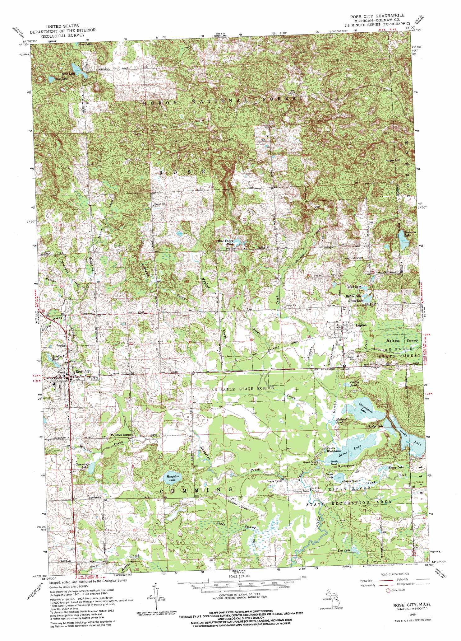
USGS Topo Quad 44084d1 - 1:24,000 scale
| Topo Map Name: | Rose City |
| USGS Topo Quad ID: | 44084d1 |
| Print Size: | ca. 21 1/4" wide x 27" high |
| Southeast Coordinates: | 44.375° N latitude / 84° W longitude |
| Map Center Coordinates: | 44.4375° N latitude / 84.0625° W longitude |
| U.S. State: | MI |
| Filename: | o44084d1.jpg |
| Download Map JPG Image: | Rose City topo map 1:24,000 scale |
| Map Type: | Topographic |
| Topo Series: | 7.5´ |
| Map Scale: | 1:24,000 |
| Source of Map Images: | United States Geological Survey (USGS) |
| Alternate Map Versions: |
Rose City MI 1965, updated 1967 Download PDF Buy paper map Rose City MI 1965, updated 1982 Download PDF Buy paper map Rose City MI 1965, updated 1982 Download PDF Buy paper map Rose City MI 2012 Download PDF Buy paper map Rose City MI 2014 Download PDF Buy paper map Rose City MI 2017 Download PDF Buy paper map |
| FStopo: | US Forest Service topo Rose City is available: Download FStopo PDF Download FStopo TIF |
1:24,000 Topo Quads surrounding Rose City
Red Oak |
Mio |
Fairview |
Mckinley |
Curran |
Luzerne |
Island Lake |
Mack Lake |
Goodar |
Alcona Dam Pond |
Saint Helen Ne |
Damon |
Rose City |
South Branch |
Hale |
Ogemaw Springs |
West Branch |
Selkirk |
Sage Lake |
Hale Se |
Edwards |
Sterling Nw |
Skidway Lake |
Prescott |
Whittemore |
> Back to 44084a1 at 1:100,000 scale
> Back to 44084a1 at 1:250,000 scale
> Back to U.S. Topo Maps home
Rose City topo map: Gazetteer
Rose City: Airports
Boyer Airport elevation 263m 862′Rose City: Lakes
Bass Lake elevation 389m 1276′Bear Lake elevation 367m 1204′
Cummings Lake elevation 276m 905′
Devils Washbasin elevation 265m 869′
Devoe Lake elevation 278m 912′
Eagle Lake elevation 270m 885′
Grebe Lake elevation 269m 882′
Green Lake elevation 285m 935′
Grousehaven Lake elevation 265m 869′
Jewett Lake elevation 266m 872′
Lodge Lake elevation 266m 872′
Lost Lake elevation 267m 875′
Mallard Pond elevation 266m 872′
Middle Lake elevation 285m 935′
Mud Lake elevation 285m 935′
Pintail Pond elevation 266m 872′
Rose Valley Pond elevation 297m 974′
Sandback Pond elevation 294m 964′
Scaup Lake elevation 268m 879′
South Pond elevation 268m 879′
Townline Lake elevation 327m 1072′
Rose City: Parks
Big Fire Historical Marker elevation 292m 958′Cleveland Park Pavilion Historical Marker elevation 287m 941′
Rifle River State Recreation Area elevation 268m 879′
Rose City Historical Marker elevation 292m 958′
Rose City: Populated Places
Fayettes Corner elevation 274m 898′Lupton elevation 281m 921′
Rose City elevation 292m 958′
Rose City: Post Offices
Lupton Post Office elevation 282m 925′Rose City Post Office elevation 295m 967′
Rose City: Streams
Andrews Creek elevation 285m 935′Bailer Creek elevation 271m 889′
Bixby Creek elevation 294m 964′
Brooks Creek elevation 297m 974′
Gamble Creek elevation 267m 875′
Houghton Creek elevation 264m 866′
Mayhue Creek elevation 271m 889′
Oyster Creek elevation 266m 872′
Simmons Creek elevation 296m 971′
Skunk Creek elevation 265m 869′
Vaughn Creek elevation 267m 875′
Wilkins Creek elevation 271m 889′
Rose City: Summits
Auger Hill elevation 421m 1381′Rose City: Swamps
Alger Swamp elevation 265m 869′Rose City digital topo map on disk
Buy this Rose City topo map showing relief, roads, GPS coordinates and other geographical features, as a high-resolution digital map file on DVD: