Luzerne Nw Topo Map Michigan
To zoom in, hover over the map of Luzerne Nw
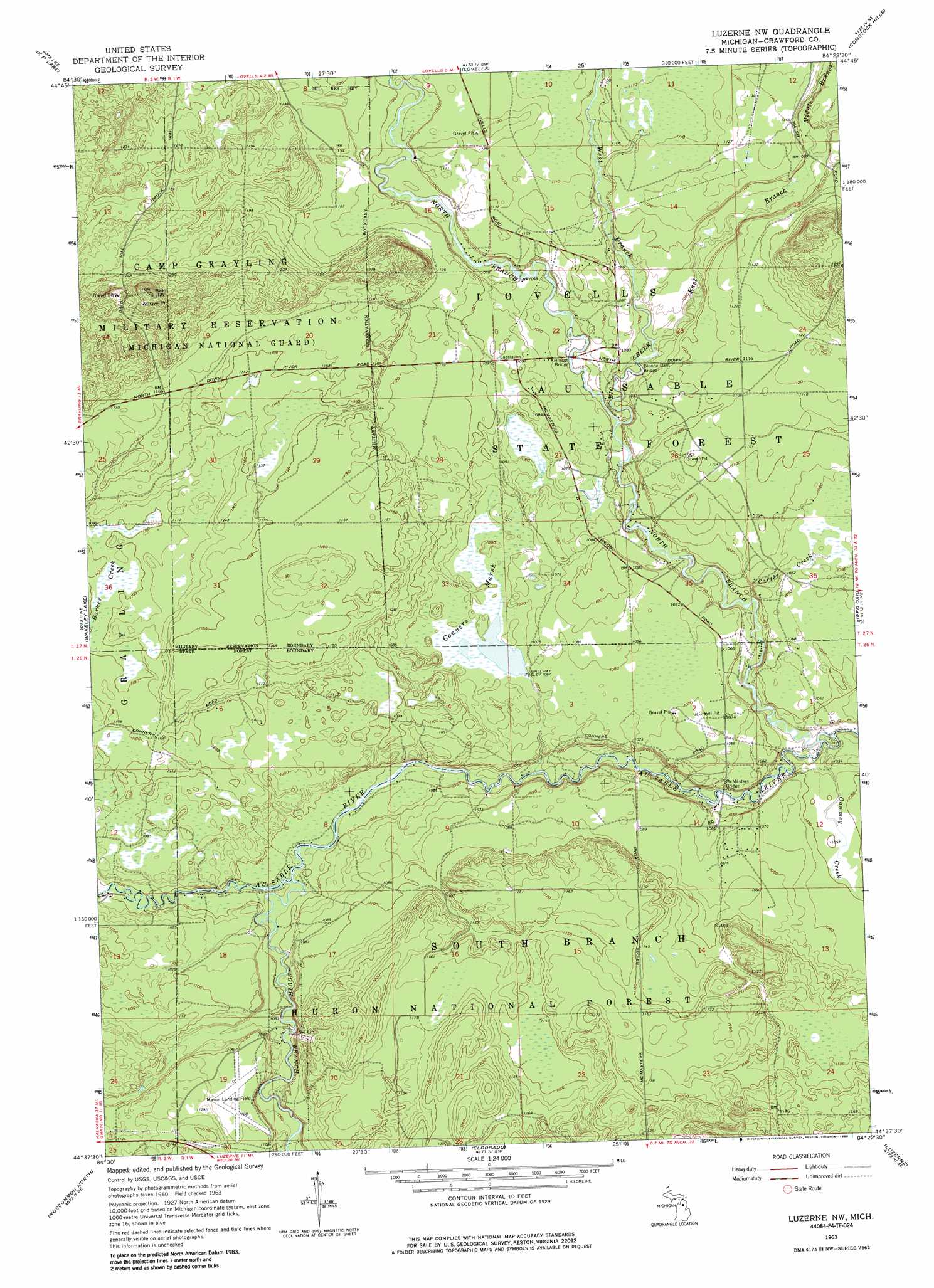
USGS Topo Quad 44084f4 - 1:24,000 scale
| Topo Map Name: | Luzerne Nw |
| USGS Topo Quad ID: | 44084f4 |
| Print Size: | ca. 21 1/4" wide x 27" high |
| Southeast Coordinates: | 44.625° N latitude / 84.375° W longitude |
| Map Center Coordinates: | 44.6875° N latitude / 84.4375° W longitude |
| U.S. State: | MI |
| Filename: | o44084f4.jpg |
| Download Map JPG Image: | Luzerne Nw topo map 1:24,000 scale |
| Map Type: | Topographic |
| Topo Series: | 7.5´ |
| Map Scale: | 1:24,000 |
| Source of Map Images: | United States Geological Survey (USGS) |
| Alternate Map Versions: |
Luzerne NW MI 1963, updated 1964 Download PDF Buy paper map Luzerne NW MI 1963, updated 1986 Download PDF Buy paper map Luzerne NW MI 1963, updated 1986 Download PDF Buy paper map Luzerne NW MI 2012 Download PDF Buy paper map Luzerne NW MI 2014 Download PDF Buy paper map Luzerne NW MI 2017 Download PDF Buy paper map |
| FStopo: | US Forest Service topo Luzerne NW is available: Download FStopo PDF Download FStopo TIF |
1:24,000 Topo Quads surrounding Luzerne Nw
Otsego Lake |
Turtle Lake |
Johannesburg |
Lewiston |
Crooked Lake |
Big Bradford Lake |
K P Lake |
Lovells |
Comstock Hills |
Oak Lake |
Grayling |
Wakeley Lake |
Luzerne Nw |
Red Oak |
Mio |
Pere Cheney |
Roscommon North |
Eldorado |
Luzerne |
Island Lake |
Lyon Manor |
Roscommon South |
Saint Helen Nw |
Saint Helen Ne |
Damon |
> Back to 44084e1 at 1:100,000 scale
> Back to 44084a1 at 1:250,000 scale
> Back to U.S. Topo Maps home
Luzerne Nw topo map: Gazetteer
Luzerne Nw: Airports
Kelleys Airport elevation 340m 1115′Luzerne Nw: Bridges
Blonde Dam Bridge elevation 320m 1049′Kelloggs Bridge elevation 320m 1049′
McMasters Bridge elevation 310m 1017′
Luzerne Nw: Streams
Big Creek elevation 320m 1049′Carter Creek elevation 312m 1023′
East Branch Big Creek elevation 321m 1053′
Gammey Creek elevation 312m 1023′
Middle Branch Big Creek elevation 332m 1089′
North Branch Au Sable River elevation 307m 1007′
South Branch Au Sable River elevation 316m 1036′
West Branch Big Creek elevation 321m 1053′
Luzerne Nw: Summits
Bald Hill elevation 426m 1397′Luzerne Nw: Swamps
Conners Marsh elevation 326m 1069′Luzerne Nw digital topo map on disk
Buy this Luzerne Nw topo map showing relief, roads, GPS coordinates and other geographical features, as a high-resolution digital map file on DVD: