Dighton Topo Map Michigan
To zoom in, hover over the map of Dighton
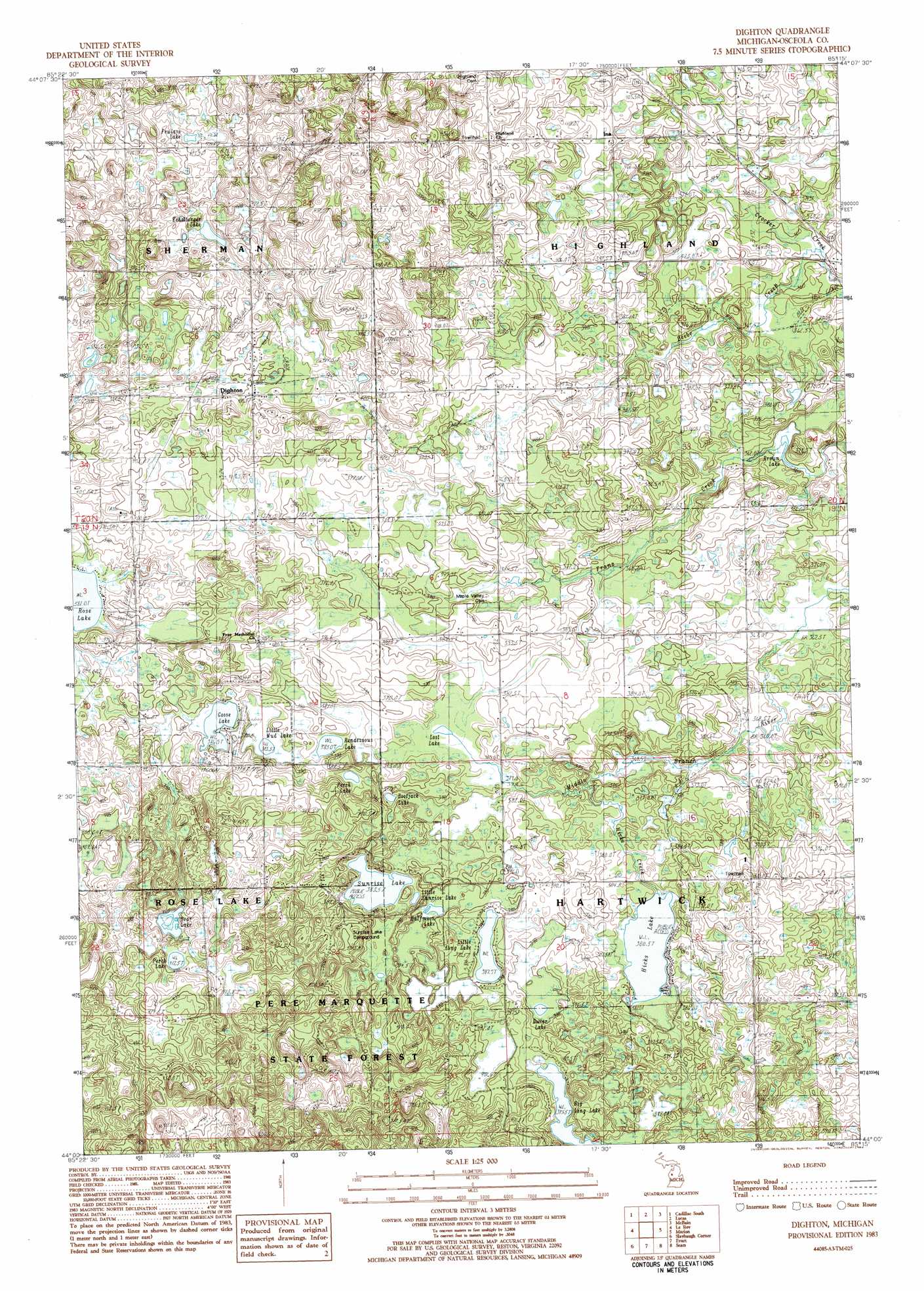
USGS Topo Quad 44085a3 - 1:25,000 scale
| Topo Map Name: | Dighton |
| USGS Topo Quad ID: | 44085a3 |
| Print Size: | ca. 21 1/4" wide x 27" high |
| Southeast Coordinates: | 44° N latitude / 85.25° W longitude |
| Map Center Coordinates: | 44.0625° N latitude / 85.3125° W longitude |
| U.S. State: | MI |
| Filename: | l44085a3.jpg |
| Download Map JPG Image: | Dighton topo map 1:25,000 scale |
| Map Type: | Topographic |
| Topo Series: | 7.5´ |
| Map Scale: | 1:25,000 |
| Source of Map Images: | United States Geological Survey (USGS) |
| Alternate Map Versions: |
Dighton MI 1983, updated 1984 Download PDF Buy paper map Dighton MI 1983, updated 1984 Download PDF Buy paper map |
1:24,000 Topo Quads surrounding Dighton
Boon |
Cadillac North |
Jennings |
Lake City |
Dinca |
Luther Ne |
Cadillac South |
Lucas |
Mcbain |
Falmouth |
Luther Se |
Le Roy |
Dighton |
Marion |
Temple |
Reed City North |
Slaybaugh Corner |
Evart |
Sears |
Lake Ne |
Reed City South |
Hersey |
Chippewa Lake North |
Merrill Lake |
Lake |
> Back to 44085a1 at 1:100,000 scale
> Back to 44084a1 at 1:250,000 scale
> Back to U.S. Topo Maps home
Dighton topo map: Gazetteer
Dighton: Lakes
Bear Lake elevation 401m 1315′Big Long Lake elevation 394m 1292′
Bootjack Lake elevation 383m 1256′
Dollar Lake elevation 389m 1276′
Echelberger Lake elevation 406m 1332′
Fewlass Lake elevation 426m 1397′
Goose Lake elevation 385m 1263′
Halfmoon Lake elevation 386m 1266′
Hicks Lake elevation 379m 1243′
John Brown Lake elevation 359m 1177′
Little Long Lake elevation 388m 1272′
Little Mud Lake elevation 383m 1256′
Little Sunrise Lake elevation 384m 1259′
Lost Lake elevation 380m 1246′
Perch Lake elevation 412m 1351′
Perch Lake elevation 382m 1253′
Rendezvous Lake elevation 382m 1253′
Sunrise Lake elevation 382m 1253′
Dighton: Populated Places
Dighton elevation 411m 1348′Ina elevation 409m 1341′
Dighton: Post Offices
Dighton Post Office (historical) elevation 411m 1348′Ina Post Office (historical) elevation 410m 1345′
Dighton: Streams
Beebe Creek elevation 359m 1177′Hicks Creek elevation 371m 1217′
Dighton digital topo map on disk
Buy this Dighton topo map showing relief, roads, GPS coordinates and other geographical features, as a high-resolution digital map file on DVD: