Traverse City Sw Topo Map Michigan
To zoom in, hover over the map of Traverse City Sw
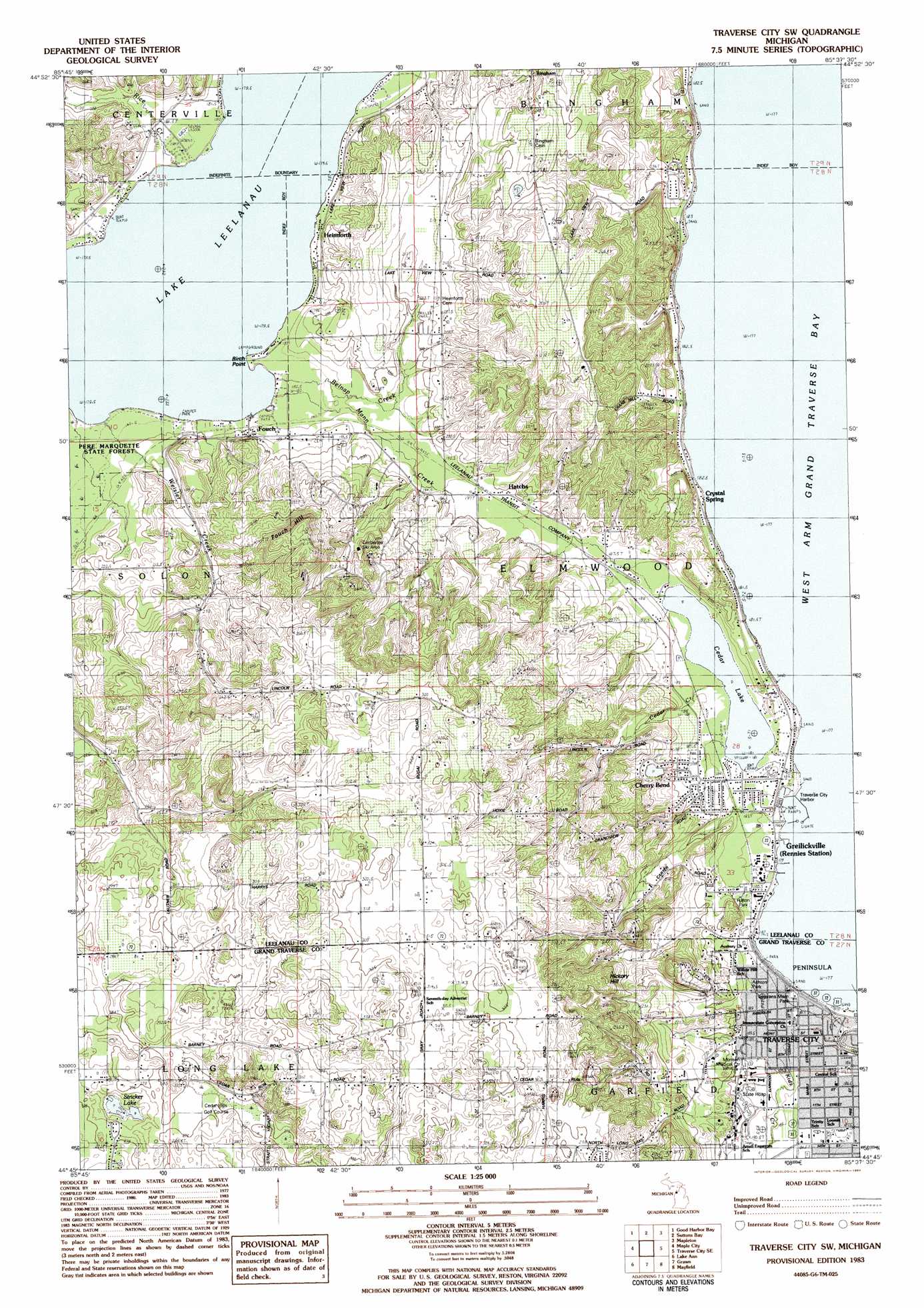
USGS Topo Quad 44085g6 - 1:25,000 scale
| Topo Map Name: | Traverse City Sw |
| USGS Topo Quad ID: | 44085g6 |
| Print Size: | ca. 21 1/4" wide x 27" high |
| Southeast Coordinates: | 44.75° N latitude / 85.625° W longitude |
| Map Center Coordinates: | 44.8125° N latitude / 85.6875° W longitude |
| U.S. State: | MI |
| Filename: | l44085g6.jpg |
| Download Map JPG Image: | Traverse City Sw topo map 1:25,000 scale |
| Map Type: | Topographic |
| Topo Series: | 7.5´ |
| Map Scale: | 1:25,000 |
| Source of Map Images: | United States Geological Survey (USGS) |
| Alternate Map Versions: |
Traverse City SW MI 1983, updated 1984 Download PDF Buy paper map |
1:24,000 Topo Quads surrounding Traverse City Sw
North Manitou Island |
Leland |
Gills Pier |
Omena |
|
Glen Arbor |
Good Harbor Bay |
Suttons Bay |
Mapleton |
Elk Rapids |
Burdickville |
Maple City |
Traverse City Sw |
Traverse City Se |
Williamsburg |
Platte River |
Lake Ann |
Grawn |
Mayfield |
Jacks Landing |
Thompsonville |
Karlin |
Buckley |
Kingsley |
Walton |
> Back to 44085e1 at 1:100,000 scale
> Back to 44084a1 at 1:250,000 scale
> Back to U.S. Topo Maps home
Traverse City Sw topo map: Gazetteer
Traverse City Sw: Airports
Munson Medical Center Heliport elevation 192m 629′Traverse City Sw: Capes
Birch Point elevation 180m 590′Traverse City Sw: Lakes
Cedar Lake elevation 181m 593′Stricker Lake elevation 257m 843′
Traverse City Sw: Parks
Ashton Park elevation 191m 626′Cherry Bend Park elevation 189m 620′
Darrow Park elevation 179m 587′
Elmwood Township Park elevation 280m 918′
Elmwood Township Park elevation 179m 587′
Fulton Park elevation 321m 1053′
Greilickville Historical Marker elevation 179m 587′
Hannah Park elevation 185m 606′
Thirlby Field elevation 187m 613′
Traverse City Regional Psychiatric Hospital Historical Marker (historical) elevation 185m 606′
Veterans Memorial Park elevation 319m 1046′
West End Park elevation 178m 583′
Traverse City Sw: Populated Places
Cherry Bend elevation 187m 613′Crystal Spring elevation 183m 600′
First Point Mobile Home Park elevation 202m 662′
Fouch elevation 189m 620′
Greilickville elevation 178m 583′
Hatchs elevation 200m 656′
Heimforth elevation 185m 606′
Traverse City Sw: Post Offices
Fouch Post Office (historical) elevation 189m 620′Norrisville Post Office (historical) elevation 178m 583′
Traverse City Sw: Reservoirs
Cherry Bend Lake elevation 208m 682′Traverse City Sw: Streams
Belnap Creek elevation 180m 590′Cedar Creek elevation 179m 587′
Kids Creek elevation 178m 583′
Mann Creek elevation 185m 606′
Rice Creek elevation 180m 590′
Weisler Creek elevation 179m 587′
Traverse City Sw: Summits
Fouch Hill elevation 321m 1053′Hickory Hill elevation 301m 987′
Traverse City Sw digital topo map on disk
Buy this Traverse City Sw topo map showing relief, roads, GPS coordinates and other geographical features, as a high-resolution digital map file on DVD: