Bellaire Topo Map Michigan
To zoom in, hover over the map of Bellaire
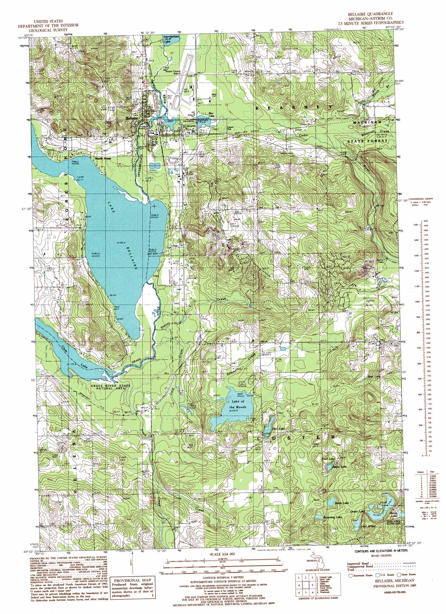
USGS Topo Quad 44085h2 - 1:24,000 scale
| Topo Map Name: | Bellaire |
| USGS Topo Quad ID: | 44085h2 |
| Print Size: | ca. 21 1/4" wide x 27" high |
| Southeast Coordinates: | 44.875° N latitude / 85.125° W longitude |
| Map Center Coordinates: | 44.9375° N latitude / 85.1875° W longitude |
| U.S. State: | MI |
| Filename: | o44085h2.jpg |
| Download Map JPG Image: | Bellaire topo map 1:24,000 scale |
| Map Type: | Topographic |
| Topo Series: | 7.5´ |
| Map Scale: | 1:24,000 |
| Source of Map Images: | United States Geological Survey (USGS) |
| Alternate Map Versions: |
Mancelona NW MI 1975, updated 1976 Download PDF Buy paper map Bellaire MI 1985, updated 1986 Download PDF Buy paper map Bellaire MI 2011 Download PDF Buy paper map Bellaire MI 2014 Download PDF Buy paper map Bellaire MI 2017 Download PDF Buy paper map |
1:24,000 Topo Quads surrounding Bellaire
Atwood |
Ellsworth |
Boyne City |
Boyne Falls |
|
Central Lake |
Scotts Lake |
Chestonia |
Deadmans Hill |
|
Elk Rapids |
Alden |
Bellaire |
Mancelona |
Alba |
Williamsburg |
Torch River |
Leetsville |
Westwood |
Starvation Lake |
Jacks Landing |
South Boardman |
Kalkaska |
Sigma |
Black Creek |
> Back to 44085e1 at 1:100,000 scale
> Back to 44084a1 at 1:250,000 scale
> Back to U.S. Topo Maps home
Bellaire topo map: Gazetteer
Bellaire: Airports
Antrim County Airport elevation 189m 620′Bellaire: Bridges
Trestle Bridge elevation 187m 613′Bellaire: Dams
Bellaire Dam elevation 186m 610′Bellaire: Lakes
Bates Lake elevation 272m 892′Boat Lake elevation 279m 915′
Browning Lake elevation 287m 941′
Clam Lake elevation 177m 580′
Finn Lake elevation 240m 787′
Green Lake elevation 297m 974′
Henry Lake elevation 301m 987′
Lake Arthur elevation 297m 974′
Lake Bellaire elevation 180m 590′
Lake of the Woods elevation 226m 741′
Mud Lake elevation 273m 895′
Smith Lake elevation 287m 941′
Bellaire: Parks
Bellaire-Antrim County Seat Historical Marker elevation 186m 610′Craven Park elevation 193m 633′
Custer Township Park elevation 239m 784′
Richardi Park elevation 187m 613′
William A Hosmer Park elevation 186m 610′
Bellaire: Populated Places
Bellaire elevation 191m 626′North Arms elevation 182m 597′
Bellaire: Post Offices
Bellaire Post Office elevation 185m 606′Rootville Post Office (historical) elevation 183m 600′
Bellaire: Reservoirs
Blair Lake elevation 190m 623′Stover Pond elevation 233m 764′
Bellaire: Streams
Cedar River elevation 187m 613′Cold Creek elevation 180m 590′
Crow Creek elevation 215m 705′
Finch Creek elevation 180m 590′
Grass River elevation 180m 590′
Intermediate River elevation 182m 597′
North Branch Cedar River elevation 204m 669′
Saloon Creek elevation 227m 744′
Shanty Creek elevation 181m 593′
Woolcott Creek elevation 209m 685′
Bellaire digital topo map on disk
Buy this Bellaire topo map showing relief, roads, GPS coordinates and other geographical features, as a high-resolution digital map file on DVD: