Good Harbor Bay Topo Map Michigan
To zoom in, hover over the map of Good Harbor Bay
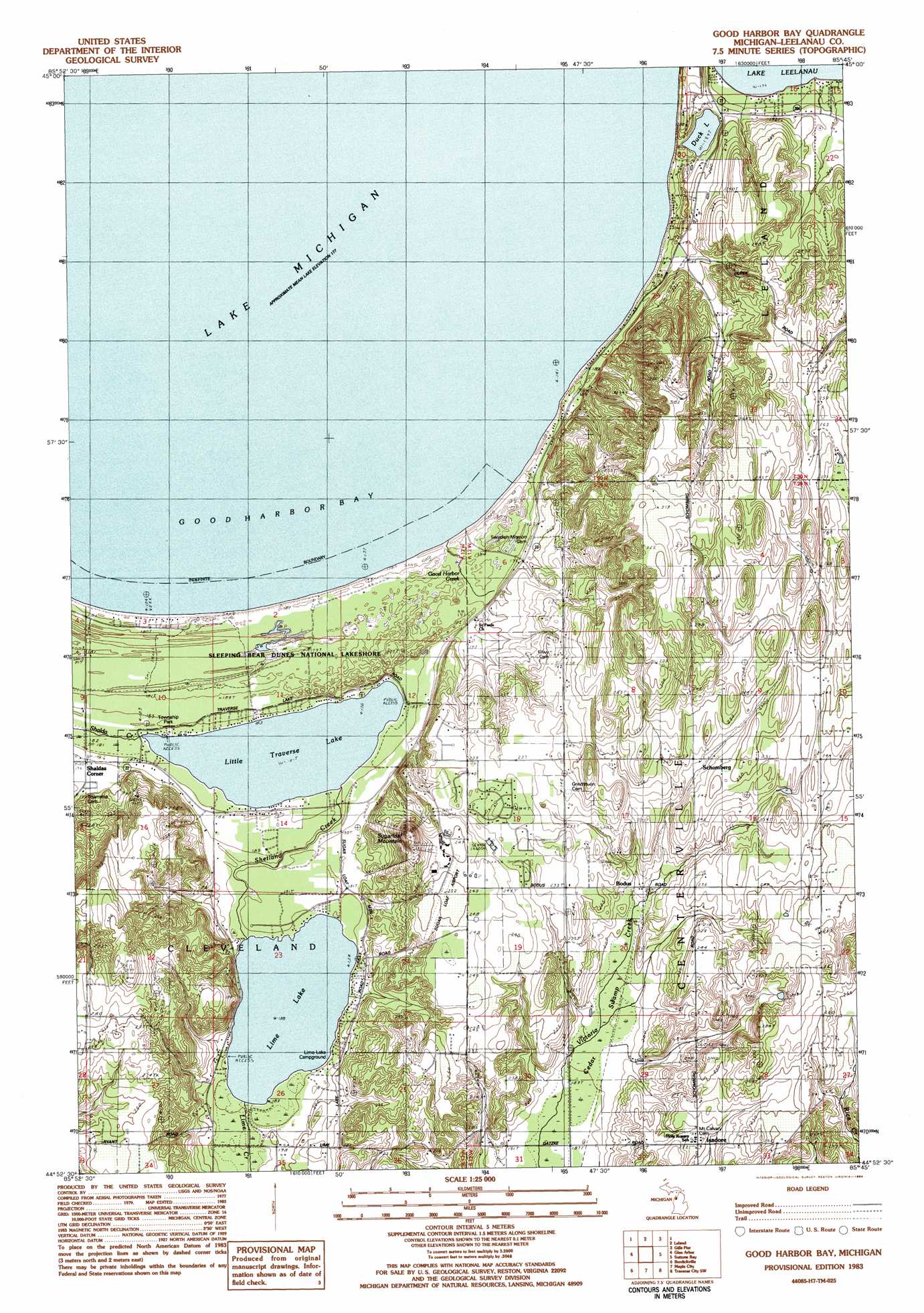
USGS Topo Quad 44085h7 - 1:25,000 scale
| Topo Map Name: | Good Harbor Bay |
| USGS Topo Quad ID: | 44085h7 |
| Print Size: | ca. 21 1/4" wide x 27" high |
| Southeast Coordinates: | 44.875° N latitude / 85.75° W longitude |
| Map Center Coordinates: | 44.9375° N latitude / 85.8125° W longitude |
| U.S. State: | MI |
| Filename: | l44085h7.jpg |
| Download Map JPG Image: | Good Harbor Bay topo map 1:25,000 scale |
| Map Type: | Topographic |
| Topo Series: | 7.5´ |
| Map Scale: | 1:25,000 |
| Source of Map Images: | United States Geological Survey (USGS) |
| Alternate Map Versions: |
Good Harbor Bay MI 1983, updated 1984 Download PDF Buy paper map Good Harbor Bay MI 1983, updated 1984 Download PDF Buy paper map |
1:24,000 Topo Quads surrounding Good Harbor Bay
Northport Nw |
Northport |
|||
South Manitou Island |
North Manitou Island |
Leland |
Gills Pier |
Omena |
Glen Haven |
Glen Arbor |
Good Harbor Bay |
Suttons Bay |
Mapleton |
Empire |
Burdickville |
Maple City |
Traverse City Sw |
Traverse City Se |
Beulah |
Platte River |
Lake Ann |
Grawn |
Mayfield |
> Back to 44085e1 at 1:100,000 scale
> Back to 44084a1 at 1:250,000 scale
> Back to U.S. Topo Maps home
Good Harbor Bay topo map: Gazetteer
Good Harbor Bay: Airports
Sugar Loaf Resort Airport elevation 252m 826′Good Harbor Bay: Bays
Good Harbor Bay elevation 177m 580′Good Harbor Bay: Lakes
Duck Lake elevation 187m 613′Lime Lake elevation 187m 613′
Little Traverse Lake elevation 181m 593′
Good Harbor Bay: Populated Places
Bodus elevation 206m 675′Isadore elevation 223m 731′
Schomberg elevation 234m 767′
Good Harbor Bay: Post Offices
Good Harbor Post Office (historical) elevation 184m 603′Isadore Post Office (historical) elevation 223m 731′
Schomberg Post Office (historical) elevation 233m 764′
Shetland Post Office (historical) elevation 200m 656′
Good Harbor Bay: Streams
Good Harbor Creek elevation 194m 636′Lime Creek elevation 188m 616′
Rice Creek elevation 225m 738′
Shetland Creek elevation 185m 606′
Good Harbor Bay: Summits
Sugarloaf Mountain elevation 252m 826′Good Harbor Bay digital topo map on disk
Buy this Good Harbor Bay topo map showing relief, roads, GPS coordinates and other geographical features, as a high-resolution digital map file on DVD: