Freesoil Se Topo Map Michigan
To zoom in, hover over the map of Freesoil Se
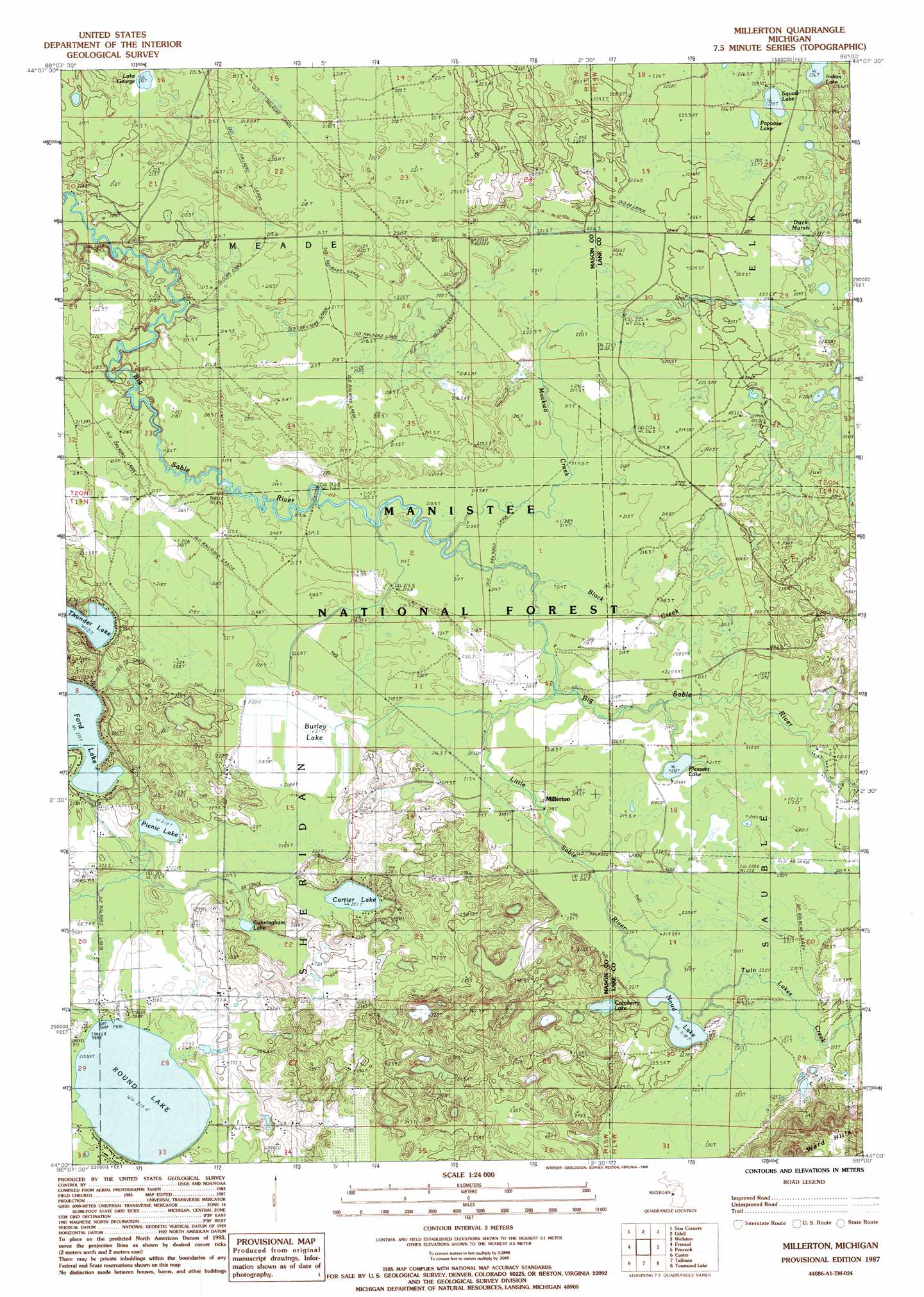
USGS Topo Quad 44086a1 - 1:24,000 scale
| Topo Map Name: | Freesoil Se |
| USGS Topo Quad ID: | 44086a1 |
| Print Size: | ca. 21 1/4" wide x 27" high |
| Southeast Coordinates: | 44° N latitude / 86° W longitude |
| Map Center Coordinates: | 44.0625° N latitude / 86.0625° W longitude |
| U.S. State: | MI |
| Filename: | o44086a1.jpg |
| Download Map JPG Image: | Freesoil Se topo map 1:24,000 scale |
| Map Type: | Topographic |
| Topo Series: | 7.5´ |
| Map Scale: | 1:24,000 |
| Source of Map Images: | United States Geological Survey (USGS) |
| Alternate Map Versions: |
Millerton MI 1987, updated 1988 Download PDF Buy paper map Millerton MI 2012 Download PDF Buy paper map Millerton MI 2014 Download PDF Buy paper map Millerton MI 2017 Download PDF Buy paper map |
| FStopo: | US Forest Service topo Millerton is available: Download FStopo PDF Download FStopo TIF |
1:24,000 Topo Quads surrounding Freesoil Se
Parkdale |
Onekama |
Brethern |
Marilla |
Yuma |
Manistee Ne |
Freesoil Nw |
Freesoil Ne |
Peacock Nw |
Peacock Ne |
Kings Corners |
Freesoil Sw |
Freesoil Se |
Peacock Sw |
Peacock Se |
Ludington Ne |
Custer Nw |
Custer Ne |
Townsend Lake |
Baldwin |
Wiley |
Custer Sw |
Custer Se |
Big Star Lake |
Marlborough |
> Back to 44086a1 at 1:100,000 scale
> Back to 44086a1 at 1:250,000 scale
> Back to U.S. Topo Maps home
Freesoil Se topo map: Gazetteer
Freesoil Se: Lakes
Cartier Lake elevation 221m 725′Cranberry Lake elevation 223m 731′
Cunningham Lake elevation 220m 721′
Ford Lake elevation 219m 718′
Indian Lake elevation 226m 741′
Lake George elevation 210m 688′
Noud Lake elevation 218m 715′
Papoose Lake elevation 226m 741′
Picnic Lake elevation 218m 715′
Pleasant Lake elevation 218m 715′
Round Lake elevation 213m 698′
Squaw Lake elevation 225m 738′
Thunder Lake elevation 221m 725′
Freesoil Se: Populated Places
Millerton elevation 219m 718′Freesoil Se: Post Offices
Millerton Post Office elevation 219m 718′Freesoil Se: Streams
Black Creek elevation 213m 698′Little Sable River elevation 216m 708′
Muckwa Creek elevation 213m 698′
Twin Lakes Creek elevation 218m 715′
Freesoil Se: Swamps
Burley Lake elevation 219m 718′Duck Marsh elevation 228m 748′
Freesoil Se digital topo map on disk
Buy this Freesoil Se topo map showing relief, roads, GPS coordinates and other geographical features, as a high-resolution digital map file on DVD: