Onekama Topo Map Michigan
To zoom in, hover over the map of Onekama
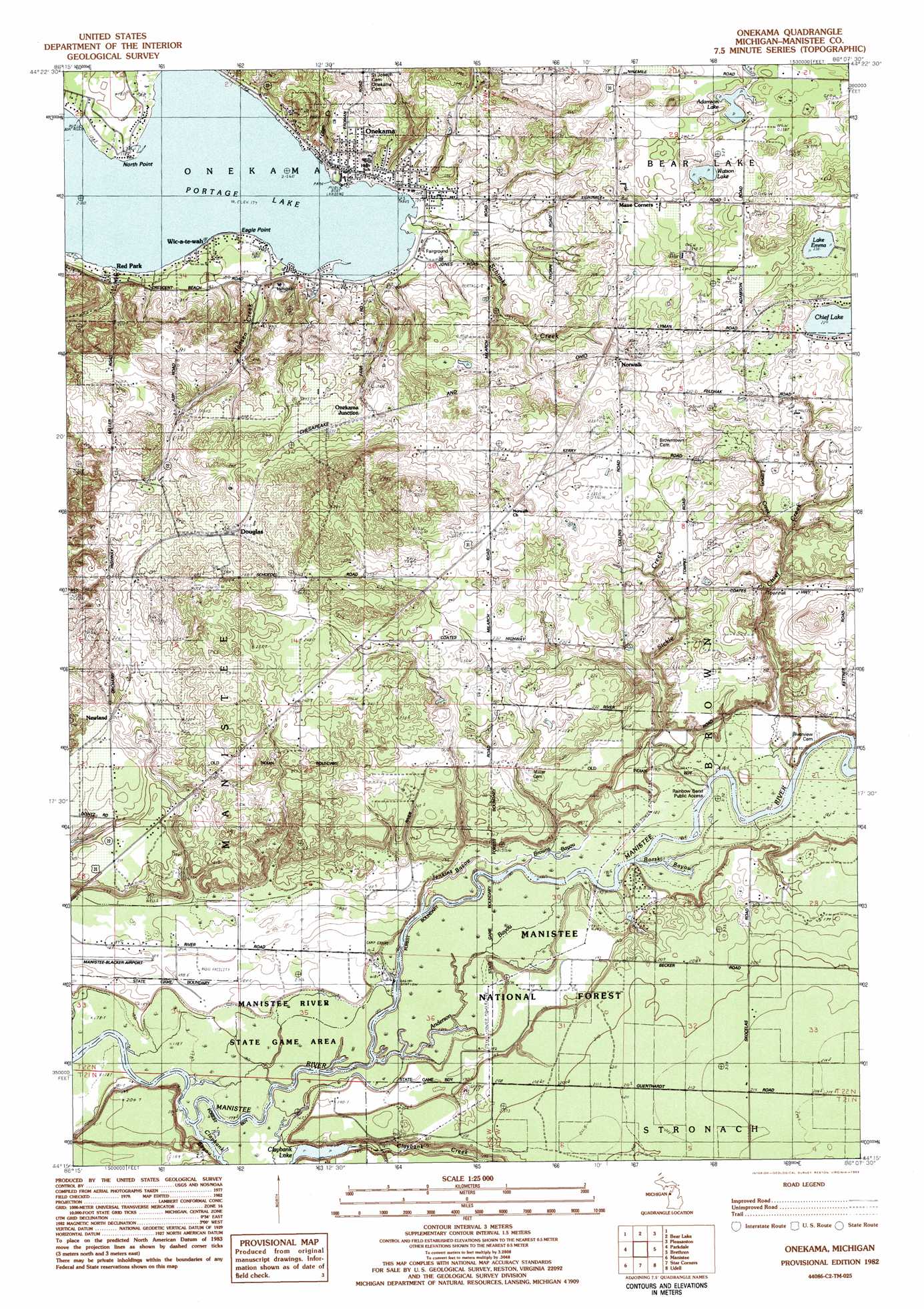
USGS Topo Quad 44086c2 - 1:25,000 scale
| Topo Map Name: | Onekama |
| USGS Topo Quad ID: | 44086c2 |
| Print Size: | ca. 21 1/4" wide x 27" high |
| Southeast Coordinates: | 44.25° N latitude / 86.125° W longitude |
| Map Center Coordinates: | 44.3125° N latitude / 86.1875° W longitude |
| U.S. State: | MI |
| Filename: | l44086c2.jpg |
| Download Map JPG Image: | Onekama topo map 1:25,000 scale |
| Map Type: | Topographic |
| Topo Series: | 7.5´ |
| Map Scale: | 1:25,000 |
| Source of Map Images: | United States Geological Survey (USGS) |
| Alternate Map Versions: |
Onekama MI 1982, updated 1983 Download PDF Buy paper map |
| FStopo: | US Forest Service topo Onekama is available: Download FStopo PDF Download FStopo TIF |
1:24,000 Topo Quads surrounding Onekama
Elberta |
Benzonia |
Thompsonville |
||
Bear Lake |
Pleasanton |
Copemish |
||
Parkdale |
Onekama |
Brethern |
Marilla |
|
Manistee Nw |
Manistee Ne |
Freesoil Nw |
Freesoil Ne |
Peacock Nw |
Hamlin Lake |
Kings Corners |
Freesoil Sw |
Freesoil Se |
Peacock Sw |
> Back to 44086a1 at 1:100,000 scale
> Back to 44086a1 at 1:250,000 scale
> Back to U.S. Topo Maps home
Onekama topo map: Gazetteer
Onekama: Airports
Manistee County-Blacker Airport elevation 189m 620′Onekama: Capes
Eagle Point elevation 177m 580′North Point elevation 177m 580′
Onekama: Guts
Anderson Bayou elevation 180m 590′Borski Bayou elevation 181m 593′
Browns Bayou elevation 181m 593′
Jenkins Bayou elevation 180m 590′
Onekama: Lakes
Adamson Lake elevation 232m 761′Claybank Lake elevation 179m 587′
Lake Emma elevation 230m 754′
Portage Lake elevation 177m 580′
Walton Pond elevation 205m 672′
Watson Lake elevation 229m 751′
Onekama: Parks
Mineral Springs Park elevation 220m 721′Onekama Village Park elevation 179m 587′
Onekama: Populated Places
Douglas elevation 247m 810′Maue Corners elevation 246m 807′
Newland elevation 219m 718′
Norwalk elevation 224m 734′
Onekama elevation 181m 593′
Onekama Junction elevation 226m 741′
Red Park elevation 178m 583′
Wic-a-te-wah elevation 179m 587′
Onekama: Post Offices
Norwalk Post Office (historical) elevation 224m 734′Onekama Post Office elevation 183m 600′
Onekama: Streams
Chief Creek elevation 181m 593′Claybank Bayou elevation 179m 587′
Claybank Creek elevation 180m 590′
Dunham Creek elevation 185m 606′
Hansen Creek elevation 177m 580′
Larson Creek elevation 207m 679′
Schimke Creek elevation 177m 580′
Sickle Creek elevation 182m 597′
Onekama digital topo map on disk
Buy this Onekama topo map showing relief, roads, GPS coordinates and other geographical features, as a high-resolution digital map file on DVD: