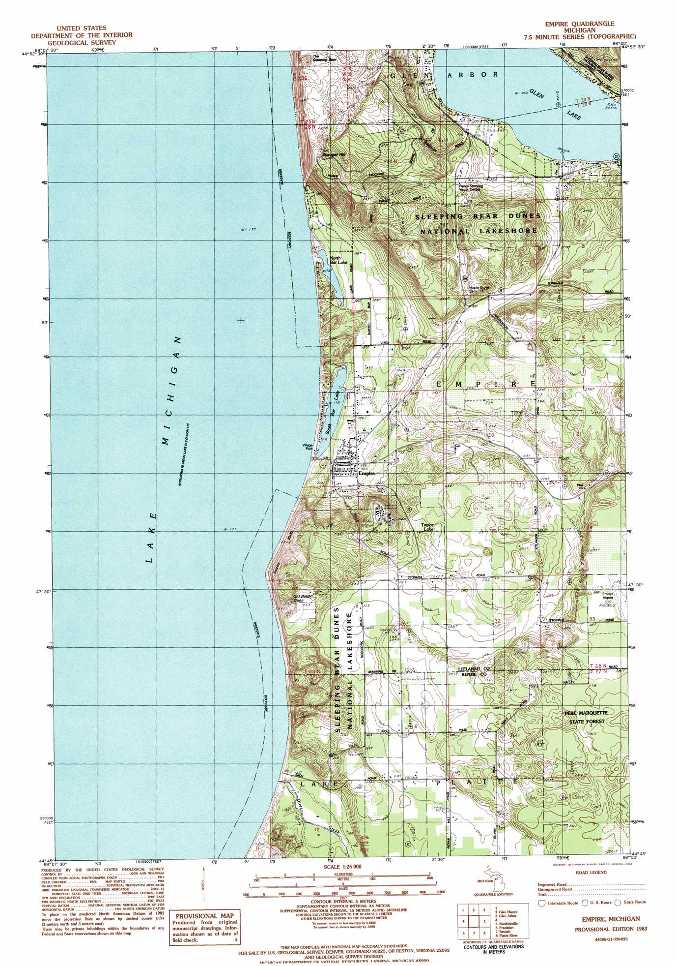
Empire Topo Map Michigan
To zoom in, hover over the map of Empire
USGS Topo Quad 44086g1 - 1:25,000 scale
| Topo Map Name: | Empire |
| USGS Topo Quad ID: | 44086g1 |
| Print Size: | ca. 21 1/4" wide x 27" high |
| Southeast Coordinates: | 44.75° N latitude / 86° W longitude |
| Map Center Coordinates: | 44.8125° N latitude / 86.0625° W longitude |
| U.S. State: | MI |
| Filename: | l44086g1.jpg |
| Download Map JPG Image: | Empire topo map 1:25,000 scale |
| Map Type: | Topographic |
| Topo Series: | 7.5´ |
| Map Scale: | 1:25,000 |
| Source of Map Images: | United States Geological Survey (USGS) |
| Alternate Map Versions: |
Empire MI 1983, updated 1984 Download PDF Buy paper map Empire MI 1983, updated 1984 Download PDF Buy paper map |
1:24,000 Topo Quads surrounding Empire
South Manitou Island |
North Manitou Island |
Leland |
||
Glen Haven |
Glen Arbor |
Good Harbor Bay |
||
Empire |
Burdickville |
Maple City |
||
Frankfort |
Beulah |
Platte River |
Lake Ann |
|
Elberta |
Benzonia |
Thompsonville |
Karlin |
> Back to 44086e1 at 1:100,000 scale
> Back to 44086a1 at 1:250,000 scale
> Back to U.S. Topo Maps home
Empire topo map: Gazetteer
Empire: Airports
Empire Airport elevation 285m 935′Empire: Cliffs
Empire Bluffs elevation 307m 1007′Empire: Lakes
North Bar Lake elevation 177m 580′South Bar Lake elevation 177m 580′
Taylor Lake elevation 248m 813′
Empire: Parks
Empire Lumber County Historical Marker elevation 185m 606′James R Johnson Park elevation 182m 597′
North Empire Park elevation 274m 898′
Village Park elevation 179m 587′
Empire: Populated Places
Aral (historical) elevation 185m 606′Empire elevation 186m 610′
Glen Lake Trailer Park elevation 189m 620′
Empire: Post Offices
Aral Post Office (historical) elevation 184m 603′Empire Post Office elevation 184m 603′
Glenmere Post Office (historical) elevation 189m 620′
Platte Post Office (historical) elevation 222m 728′
South Manitou Post Office (historical) elevation 177m 580′
Empire: Streams
Otter Creek elevation 178m 583′Empire: Summits
Old Baldy Dune elevation 300m 984′Shauger Hill elevation 291m 954′
The Sleeping Bear elevation 294m 964′
Empire digital topo map on disk
Buy this Empire topo map showing relief, roads, GPS coordinates and other geographical features, as a high-resolution digital map file on DVD: