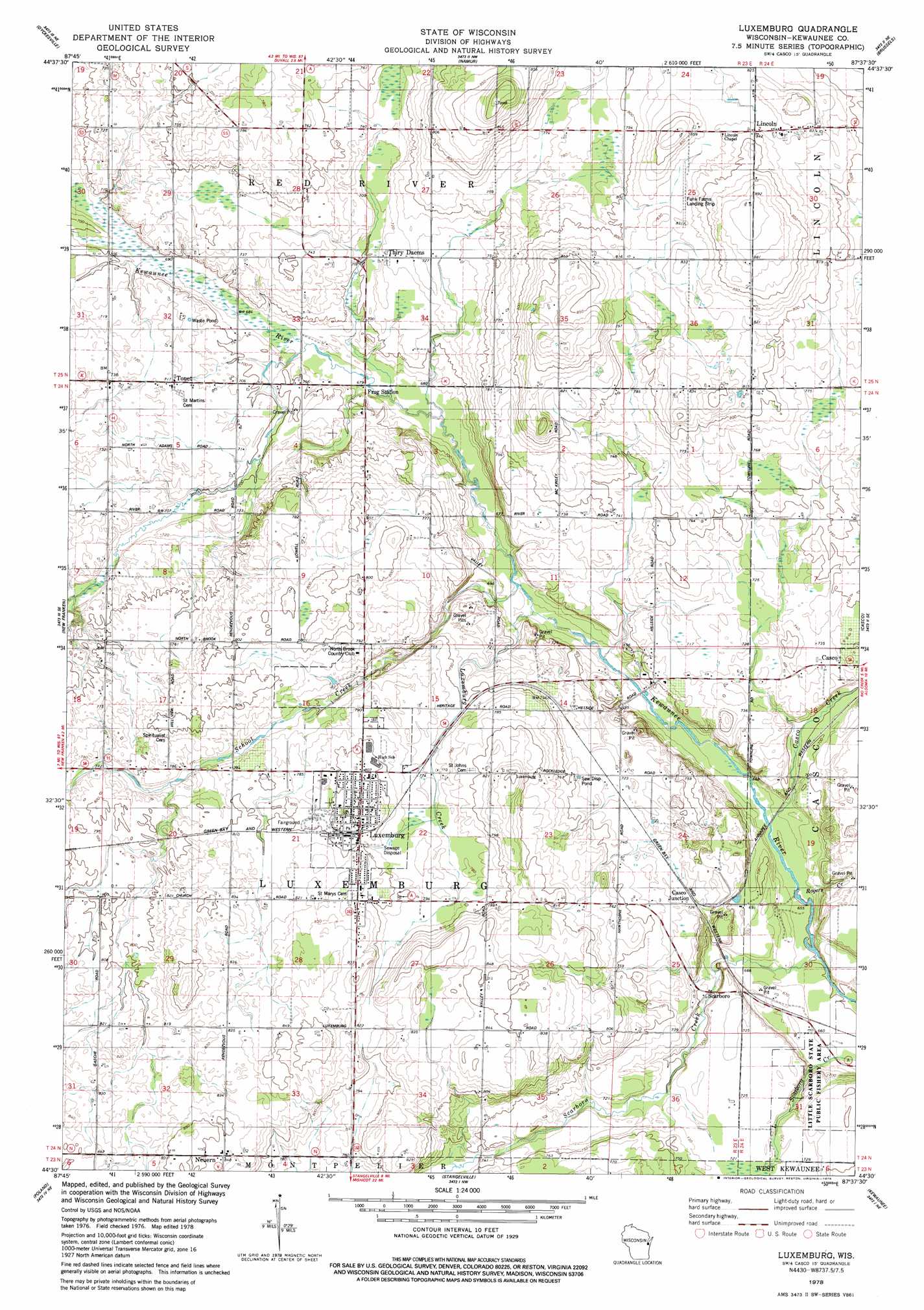
Luxemburg Topo Map Wisconsin
To zoom in, hover over the map of Luxemburg
USGS Topo Quad 44087e6 - 1:24,000 scale
| Topo Map Name: | Luxemburg |
| USGS Topo Quad ID: | 44087e6 |
| Print Size: | ca. 21 1/4" wide x 27" high |
| Southeast Coordinates: | 44.5° N latitude / 87.625° W longitude |
| Map Center Coordinates: | 44.5625° N latitude / 87.6875° W longitude |
| U.S. State: | WI |
| Filename: | o44087e6.jpg |
| Download Map JPG Image: | Luxemburg topo map 1:24,000 scale |
| Map Type: | Topographic |
| Topo Series: | 7.5´ |
| Map Scale: | 1:24,000 |
| Source of Map Images: | United States Geological Survey (USGS) |
| Alternate Map Versions: |
Luxemburg WI 1978, updated 1979 Download PDF Buy paper map Luxemburg WI 2010 Download PDF Buy paper map Luxemburg WI 2013 Download PDF Buy paper map Luxemburg WI 2015 Download PDF Buy paper map |
1:24,000 Topo Quads surrounding Luxemburg
Pensaukee |
Oconto Se |
Little Sturgeon Sw |
Little Sturgeon |
Sturgeon Bay West |
Little Tail Point |
Dyckesville |
Namur |
Brussels |
Forestville |
Green Bay East |
New Franken |
Luxemburg |
Casco |
Algoma |
Bellevue |
Poland |
Stangelville |
Kewaunee |
|
Morrison |
Denmark |
Larrabee |
Two Creeks |
> Back to 44087e1 at 1:100,000 scale
> Back to 44086a1 at 1:250,000 scale
> Back to U.S. Topo Maps home
Luxemburg topo map: Gazetteer
Luxemburg: Airports
Funk Farms Airport elevation 250m 820′Luxemburg: Parks
Little Scarboro State Public Fishery Area elevation 220m 721′Luxemburg: Populated Places
Casco Junction elevation 220m 721′Lincoln elevation 256m 839′
Luxemburg elevation 244m 800′
Neuern elevation 257m 843′
Thiry Daems elevation 221m 725′
Tonet elevation 219m 718′
Luxemburg: Streams
Casco Creek elevation 199m 652′Luxemburg Creek elevation 203m 666′
Rogers Creek elevation 199m 652′
Scarboro Creek elevation 198m 649′
School Creek elevation 204m 669′
Luxemburg digital topo map on disk
Buy this Luxemburg topo map showing relief, roads, GPS coordinates and other geographical features, as a high-resolution digital map file on DVD: