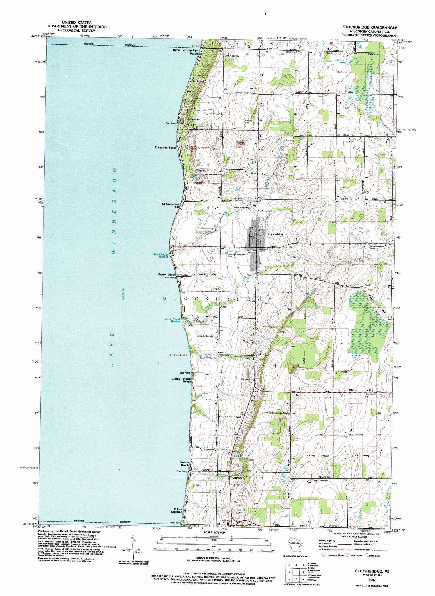
Stockbridge Topo Map Wisconsin
To zoom in, hover over the map of Stockbridge
USGS Topo Quad 44088a3 - 1:24,000 scale
| Topo Map Name: | Stockbridge |
| USGS Topo Quad ID: | 44088a3 |
| Print Size: | ca. 21 1/4" wide x 27" high |
| Southeast Coordinates: | 44° N latitude / 88.25° W longitude |
| Map Center Coordinates: | 44.0625° N latitude / 88.3125° W longitude |
| U.S. State: | WI |
| Filename: | o44088a3.jpg |
| Download Map JPG Image: | Stockbridge topo map 1:24,000 scale |
| Map Type: | Topographic |
| Topo Series: | 7.5´ |
| Map Scale: | 1:24,000 |
| Source of Map Images: | United States Geological Survey (USGS) |
| Alternate Map Versions: |
Stockbridge WI 1974, updated 1978 Download PDF Buy paper map Stockbridge WI 1992, updated 1996 Download PDF Buy paper map Stockbridge WI 2010 Download PDF Buy paper map Stockbridge WI 2013 Download PDF Buy paper map Stockbridge WI 2016 Download PDF Buy paper map |
1:24,000 Topo Quads surrounding Stockbridge
Greenville |
Appleton |
Kaukauna |
Wrightstown |
Greenleaf |
Oshkosh Ne |
Neenah |
Sherwood |
Hilbert |
Brillion |
Oshkosh |
Indian Point |
Stockbridge |
Chilton |
Potter |
Van Dyne |
Fahrney Point |
Brothertown |
Marytown |
Kiel |
Eldorado |
Fond Du Lac |
Saint Peter |
Saint Cloud |
Elkhart Lake |
> Back to 44088a1 at 1:100,000 scale
> Back to 44088a1 at 1:250,000 scale
> Back to U.S. Topo Maps home
Stockbridge topo map: Gazetteer
Stockbridge: Bays
Mud Creek Harbor elevation 228m 748′Stockbridge Harbor elevation 228m 748′
Stockbridge: Populated Places
Dorns Faro Springs Beach elevation 234m 767′Dorns Twilight Beach elevation 233m 764′
Eckers Lakeland elevation 233m 764′
Kloten elevation 313m 1026′
Quinney elevation 265m 869′
Rockaway Beach elevation 232m 761′
Saint Catherines Bay elevation 239m 784′
Stockbridge elevation 251m 823′
Sunset Beach elevation 229m 751′
Stockbridge: Streams
Johnson Creek elevation 228m 748′Mill Creek elevation 228m 748′
Mud Creek elevation 228m 748′
Roberts Creek elevation 228m 748′
Stockbridge digital topo map on disk
Buy this Stockbridge topo map showing relief, roads, GPS coordinates and other geographical features, as a high-resolution digital map file on DVD: