Gillett Topo Map Wisconsin
To zoom in, hover over the map of Gillett
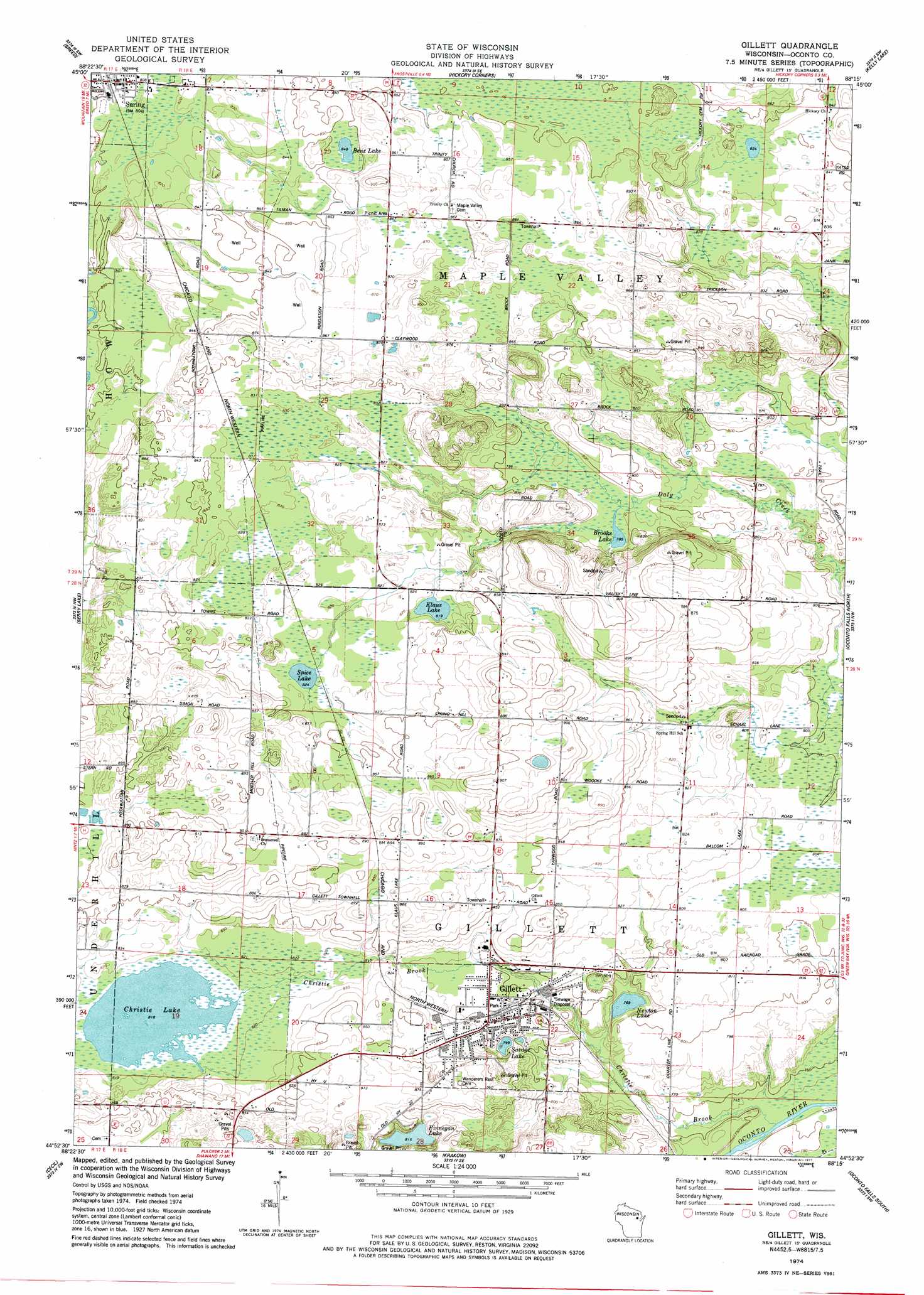
USGS Topo Quad 44088h3 - 1:24,000 scale
| Topo Map Name: | Gillett |
| USGS Topo Quad ID: | 44088h3 |
| Print Size: | ca. 21 1/4" wide x 27" high |
| Southeast Coordinates: | 44.875° N latitude / 88.25° W longitude |
| Map Center Coordinates: | 44.9375° N latitude / 88.3125° W longitude |
| U.S. State: | WI |
| Filename: | o44088h3.jpg |
| Download Map JPG Image: | Gillett topo map 1:24,000 scale |
| Map Type: | Topographic |
| Topo Series: | 7.5´ |
| Map Scale: | 1:24,000 |
| Source of Map Images: | United States Geological Survey (USGS) |
| Alternate Map Versions: |
Gillett WI 1974, updated 1977 Download PDF Buy paper map Gillett WI 2010 Download PDF Buy paper map Gillett WI 2013 Download PDF Buy paper map Gillett WI 2016 Download PDF Buy paper map |
1:24,000 Topo Quads surrounding Gillett
Shadow Lake |
Mountain |
Shay Lake |
White Potato Lake |
Crivitz |
Fredenberg Lake |
Breed |
Hickory Corners |
Kelly Lake |
Coleman |
Legend Lake |
Berry Lake |
Gillett |
Oconto Falls North |
Lena |
Shawano |
Cecil |
Krakow |
Oconto Falls South |
Abrams |
Lunds |
Bonduel |
Zachow |
Pulaski |
Suamico |
> Back to 44088e1 at 1:100,000 scale
> Back to 44088a1 at 1:250,000 scale
> Back to U.S. Topo Maps home
Gillett topo map: Gazetteer
Gillett: Lakes
Benz Lake elevation 259m 849′Brooks Lake elevation 239m 784′
Christie Lake elevation 249m 816′
Finnegan Lake elevation 249m 816′
Klaus Lake elevation 250m 820′
Newton Lake elevation 234m 767′
Savage Lake elevation 244m 800′
Spice Lake elevation 251m 823′
Gillett: Populated Places
Gillett elevation 247m 810′Suring elevation 244m 800′
Gillett: Streams
Christie Brook elevation 224m 734′Gillett digital topo map on disk
Buy this Gillett topo map showing relief, roads, GPS coordinates and other geographical features, as a high-resolution digital map file on DVD: