Wisconsin Rapids South Topo Map Wisconsin
To zoom in, hover over the map of Wisconsin Rapids South
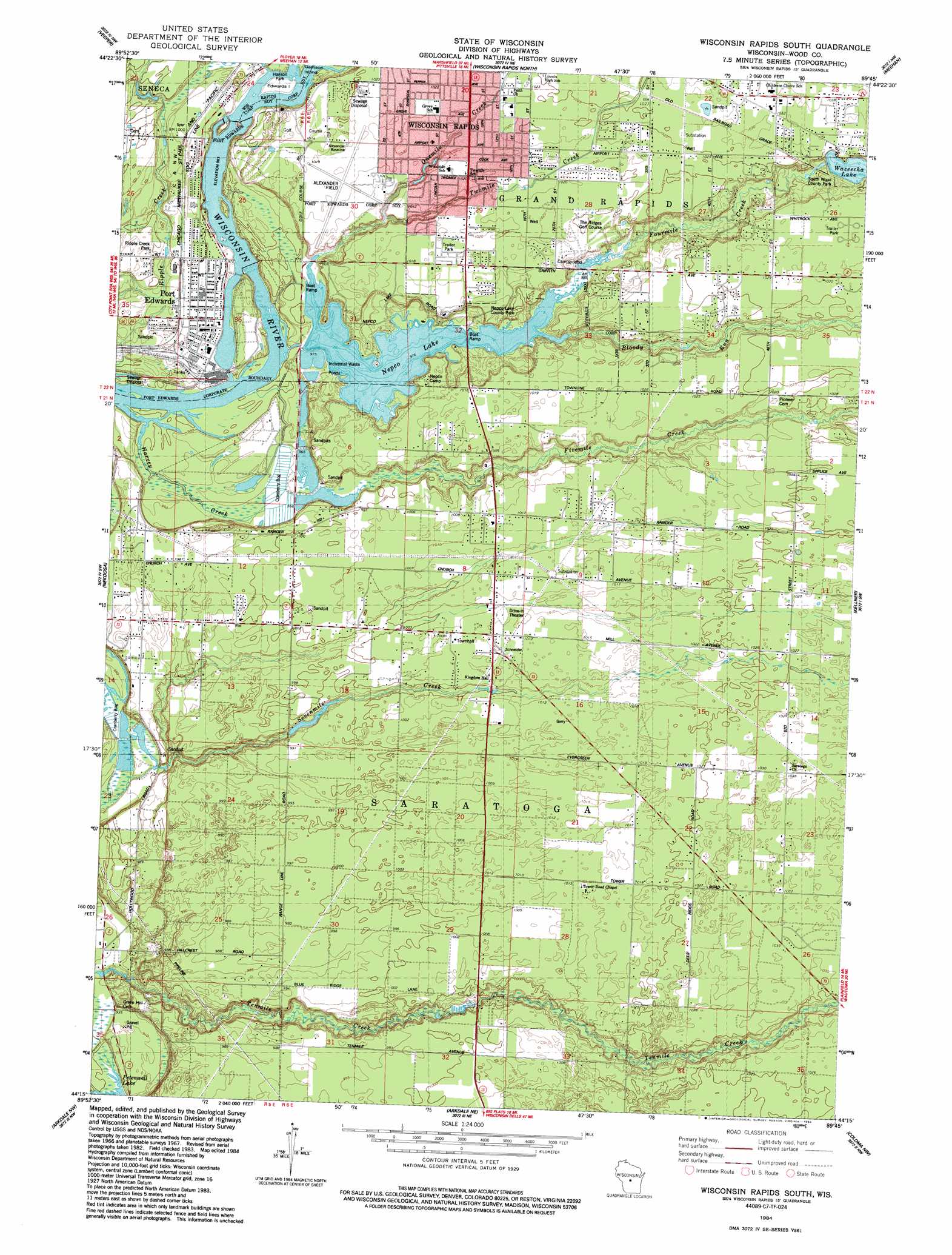
USGS Topo Quad 44089c7 - 1:24,000 scale
| Topo Map Name: | Wisconsin Rapids South |
| USGS Topo Quad ID: | 44089c7 |
| Print Size: | ca. 21 1/4" wide x 27" high |
| Southeast Coordinates: | 44.25° N latitude / 89.75° W longitude |
| Map Center Coordinates: | 44.3125° N latitude / 89.8125° W longitude |
| U.S. State: | WI |
| Filename: | o44089c7.jpg |
| Download Map JPG Image: | Wisconsin Rapids South topo map 1:24,000 scale |
| Map Type: | Topographic |
| Topo Series: | 7.5´ |
| Map Scale: | 1:24,000 |
| Source of Map Images: | United States Geological Survey (USGS) |
| Alternate Map Versions: |
Wisconsin Rapids South WI 1984, updated 1984 Download PDF Buy paper map Wisconsin Rapids South WI 2010 Download PDF Buy paper map Wisconsin Rapids South WI 2013 Download PDF Buy paper map Wisconsin Rapids South WI 2015 Download PDF Buy paper map |
1:24,000 Topo Quads surrounding Wisconsin Rapids South
Marshfield |
Sherry |
Junction City |
Rocky Run |
Stevens Point |
Lake Dexter |
Vesper |
Wisconsin Rapids North |
Meehan |
Whiting |
Babcock |
Nekoosa |
Wisconsin Rapids South |
Kellner |
Bancroft |
New Miner |
Arkdale Nw |
Arkdale Ne |
Coloma Nw |
Hancock |
Necedah |
Arkdale |
Roche A Cri |
Coloma Sw |
Coloma |
> Back to 44089a1 at 1:100,000 scale
> Back to 44088a1 at 1:250,000 scale
> Back to U.S. Topo Maps home
Wisconsin Rapids South topo map: Gazetteer
Wisconsin Rapids South: Airports
Alexander Field South Wood County Airport elevation 310m 1017′Wisconsin Rapids South: Dams
Carl D4803 Dam elevation 301m 987′Centralia 1887C29 Dam elevation 299m 980′
Five Mile Creek 2WP976 Dam elevation 291m 954′
Nepco Lake Dam elevation 298m 977′
Port Edwards 1874C276 Dam elevation 289m 948′
South Wood County Park 2WP244 Dam elevation 311m 1020′
Wisconsin Rapids South: Islands
Edwards Island elevation 300m 984′Wisconsin Rapids South: Parks
Edwards Alexander Memorial Park elevation 294m 964′Nepco Lake County Park elevation 306m 1003′
Ripple Creek Park elevation 297m 974′
Wisconsin Rapids South: Populated Places
Lake Wazeecha elevation 315m 1033′Port Edwards elevation 297m 974′
Wisconsin Rapids South: Post Offices
Port Edwards Post Office elevation 295m 967′Wisconsin Rapids South: Reservoirs
2 Reservoir elevation 301m 987′Centralia Flowage 5401 elevation 299m 980′
Lake 6-7 and 6-6c 14 elevation 291m 954′
Nepco Lake elevation 298m 977′
Nepco Lake 175 elevation 294m 964′
Port Edwards Flowage 5405 elevation 289m 948′
Wazeecha Lake elevation 310m 1017′
Wazeecha Lake 100 elevation 311m 1020′
Wisconsin Rapids South: Streams
Bloody Run elevation 297m 974′Fivemile Creek elevation 295m 967′
Fourmile Creek elevation 298m 977′
Harvey Creek elevation 289m 948′
Onemile Creek elevation 302m 990′
Twomile Creek elevation 298m 977′
Wisconsin Rapids South digital topo map on disk
Buy this Wisconsin Rapids South topo map showing relief, roads, GPS coordinates and other geographical features, as a high-resolution digital map file on DVD: