Wittenberg Topo Map Wisconsin
To zoom in, hover over the map of Wittenberg
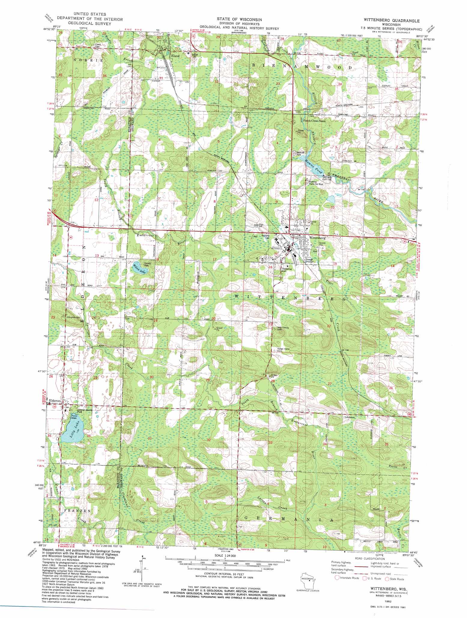
USGS Topo Quad 44089g2 - 1:24,000 scale
| Topo Map Name: | Wittenberg |
| USGS Topo Quad ID: | 44089g2 |
| Print Size: | ca. 21 1/4" wide x 27" high |
| Southeast Coordinates: | 44.75° N latitude / 89.125° W longitude |
| Map Center Coordinates: | 44.8125° N latitude / 89.1875° W longitude |
| U.S. State: | WI |
| Filename: | o44089g2.jpg |
| Download Map JPG Image: | Wittenberg topo map 1:24,000 scale |
| Map Type: | Topographic |
| Topo Series: | 7.5´ |
| Map Scale: | 1:24,000 |
| Source of Map Images: | United States Geological Survey (USGS) |
| Alternate Map Versions: |
Wittenberg WI 1982, updated 1982 Download PDF Buy paper map Wittenberg WI 2010 Download PDF Buy paper map Wittenberg WI 2013 Download PDF Buy paper map Wittenberg WI 2015 Download PDF Buy paper map |
1:24,000 Topo Quads surrounding Wittenberg
Kalinke |
Hogarty |
Aniwa |
Mattoon |
Zoar |
Ringle |
Hatley |
Birnamwood |
Regina |
Burney Lake |
Bevent |
Mission Lake |
Wittenberg |
Shepley |
Bowler |
Rosholt Nw |
Rosholt |
Tigerton Nw |
Tigerton |
Marion |
Polonia |
New Hope |
Iola |
Big Falls |
Symco |
> Back to 44089e1 at 1:100,000 scale
> Back to 44088a1 at 1:250,000 scale
> Back to U.S. Topo Maps home
Wittenberg topo map: Gazetteer
Wittenberg: Dams
Wittenberg 1885c235 Dam elevation 356m 1167′Wittenberg: Lakes
Lilly Lake elevation 361m 1184′Wilson Lake elevation 367m 1204′
Wittenberg: Parks
Elderon County Park elevation 360m 1181′Wittenberg: Populated Places
Eland elevation 376m 1233′Elderon elevation 366m 1200′
Wittenberg elevation 358m 1174′
Wittenberg: Reservoirs
Homme Pond elevation 355m 1164′Homme Pond 75 elevation 356m 1167′
Wittenberg: Streams
Larsen Creek elevation 334m 1095′Norrie Brook elevation 376m 1233′
Packard Creek elevation 363m 1190′
Railroad Creek elevation 377m 1236′
Spranger Creek elevation 350m 1148′
Wittenberg digital topo map on disk
Buy this Wittenberg topo map showing relief, roads, GPS coordinates and other geographical features, as a high-resolution digital map file on DVD: