Finley Topo Map Wisconsin
To zoom in, hover over the map of Finley
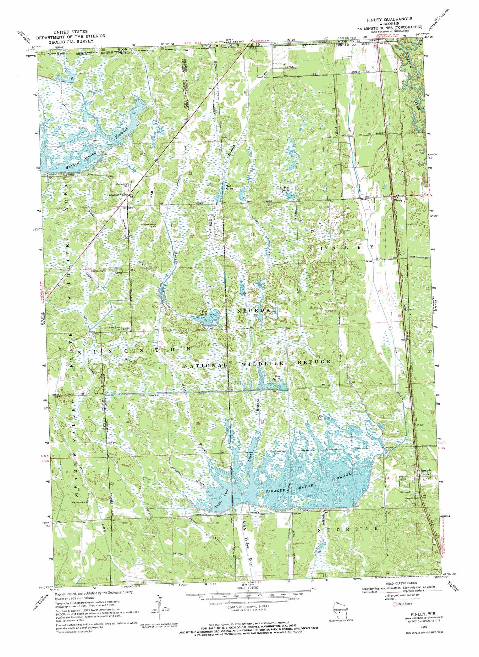
USGS Topo Quad 44090b2 - 1:24,000 scale
| Topo Map Name: | Finley |
| USGS Topo Quad ID: | 44090b2 |
| Print Size: | ca. 21 1/4" wide x 27" high |
| Southeast Coordinates: | 44.125° N latitude / 90.125° W longitude |
| Map Center Coordinates: | 44.1875° N latitude / 90.1875° W longitude |
| U.S. State: | WI |
| Filename: | o44090b2.jpg |
| Download Map JPG Image: | Finley topo map 1:24,000 scale |
| Map Type: | Topographic |
| Topo Series: | 7.5´ |
| Map Scale: | 1:24,000 |
| Source of Map Images: | United States Geological Survey (USGS) |
| Alternate Map Versions: |
Finley WI 1969, updated 1971 Download PDF Buy paper map Finley WI 2010 Download PDF Buy paper map Finley WI 2013 Download PDF Buy paper map Finley WI 2015 Download PDF Buy paper map |
1:24,000 Topo Quads surrounding Finley
City Point Nw |
City Point Ne |
Pittsville |
Lake Dexter |
Vesper |
Spaulding |
City Point |
Quail Point Flowage |
Babcock |
Nekoosa |
Warrens East |
Mather |
Finley |
New Miner |
Arkdale Nw |
Wyeville |
Shennington |
Cutler |
Necedah |
Arkdale |
Oakdale |
Camp Douglas |
New Lisbon North |
Kelly |
Dellwood |
> Back to 44090a1 at 1:100,000 scale
> Back to 44090a1 at 1:250,000 scale
> Back to U.S. Topo Maps home
Finley topo map: Gazetteer
Finley: Canals
Albreit Lateral elevation 286m 938′Avery Lateral elevation 288m 944′
Danielson Lateral elevation 289m 948′
East Branch Spencer Robinson Ditch elevation 287m 941′
Johnson Lateral elevation 292m 958′
McConnell Lateral elevation 293m 961′
McDowell Lateral elevation 287m 941′
Morse Lateral elevation 292m 958′
Neal Lateral elevation 289m 948′
Rawson Lateral elevation 291m 954′
Rogers Lateral elevation 291m 954′
Russell Lateral elevation 291m 954′
Ward Lateral elevation 290m 951′
Finley: Dams
Little Yellow 11 Dam elevation 286m 938′Little Yellow 13 Dam elevation 288m 944′
Little Yellow 18 3NC79008 Dam elevation 290m 951′
Little Yellow 19 Dam elevation 290m 951′
Little Yellow 25 Dam elevation 293m 961′
Little Yellow 27 Dam elevation 290m 951′
Little Yellow 30 Dam elevation 293m 961′
Little Yellow 9 Dam elevation 287m 941′
Meadow Valley Spillway 5 G12.759 Dam elevation 294m 964′
Meadow Valley Spillway 6 2WP395 Dam elevation 293m 961′
Meadow Valley Spillway 7 2WP395 Dam elevation 293m 961′
Necedah Wildlife Refuge 30 Dam elevation 288m 944′
Necedah Wildlife Refuge 33 Dam elevation 288m 944′
Remington 1 2WP203 Dam elevation 292m 958′
Remington 11 2WP203 Dam elevation 293m 961′
Sprague Mather Flowage C 137.39 Dam elevation 287m 941′
Finley: Parks
Necedah National Wildlife Refuge elevation 287m 941′Necedah Oak-Pine Savanna State Natural Area elevation 288m 944′
Finley: Populated Places
Finley elevation 290m 951′Meadow Valley elevation 293m 961′
Sprague elevation 286m 938′
Finley: Reservoirs
2 Reservoir elevation 293m 961′44 Reservoir elevation 293m 961′
48 Reservoir elevation 292m 958′
6 Reservoir elevation 290m 951′
7 Reservoir elevation 290m 951′
Goose Pool elevation 287m 941′
Greenhead Flowage elevation 293m 961′
Meadow Valley Flowage elevation 294m 964′
Number Nineteen Pool elevation 290m 951′
Number Thirteen Pool elevation 288m 944′
Number Twenty-eight Pool elevation 291m 954′
Number Twenty-seven Pool elevation 290m 951′
Pool 13 3.7 elevation 288m 944′
Pool 29 8 elevation 286m 938′
Pool 9 elevation 287m 941′
Pool Number 27 4 elevation 290m 951′
Portion of Meadow Valley Flowage elevation 293m 961′
Portion of Meadow Valley Flowage elevation 294m 964′
Portion of Meadow Valley Flowage 14 elevation 294m 964′
Sprague-Mather Flowage elevation 288m 944′
Finley: Streams
East Branch Little Yellow River elevation 287m 941′West Branch Little Yellow River elevation 287m 941′
Finley digital topo map on disk
Buy this Finley topo map showing relief, roads, GPS coordinates and other geographical features, as a high-resolution digital map file on DVD: