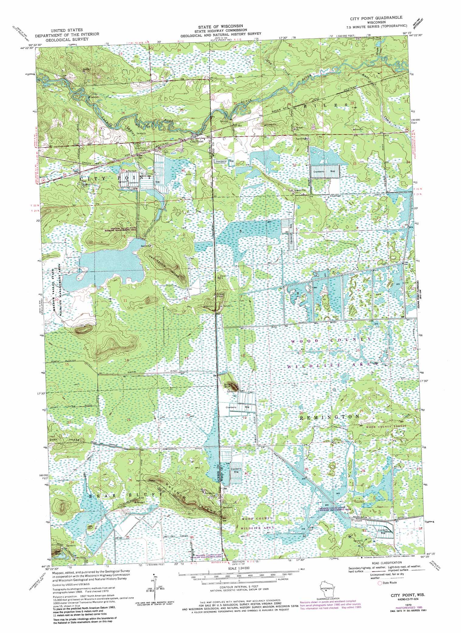
City Point Topo Map Wisconsin
To zoom in, hover over the map of City Point
USGS Topo Quad 44090c3 - 1:24,000 scale
| Topo Map Name: | City Point |
| USGS Topo Quad ID: | 44090c3 |
| Print Size: | ca. 21 1/4" wide x 27" high |
| Southeast Coordinates: | 44.25° N latitude / 90.25° W longitude |
| Map Center Coordinates: | 44.3125° N latitude / 90.3125° W longitude |
| U.S. State: | WI |
| Filename: | o44090c3.jpg |
| Download Map JPG Image: | City Point topo map 1:24,000 scale |
| Map Type: | Topographic |
| Topo Series: | 7.5´ |
| Map Scale: | 1:24,000 |
| Source of Map Images: | United States Geological Survey (USGS) |
| Alternate Map Versions: |
City Point WI 1970, updated 1972 Download PDF Buy paper map City Point WI 1970, updated 1978 Download PDF Buy paper map City Point WI 1970, updated 1985 Download PDF Buy paper map City Point WI 2010 Download PDF Buy paper map City Point WI 2013 Download PDF Buy paper map City Point WI 2015 Download PDF Buy paper map |
1:24,000 Topo Quads surrounding City Point
Neillsville |
Granton |
Lindsey |
Lake Manakiki |
Marshfield |
Hatfield Ne |
City Point Nw |
City Point Ne |
Pittsville |
Lake Dexter |
Hatfield Se |
Spaulding |
City Point |
Quail Point Flowage |
Babcock |
Warrens West |
Warrens East |
Mather |
Finley |
New Miner |
Tunnel City |
Wyeville |
Shennington |
Cutler |
Necedah |
> Back to 44090a1 at 1:100,000 scale
> Back to 44090a1 at 1:250,000 scale
> Back to U.S. Topo Maps home
City Point topo map: Gazetteer
City Point: Canals
Bissig Ditch elevation 300m 984′Hay Creek Ditch elevation 297m 974′
Remington Ditch elevation 295m 967′
Weisner Ditch elevation 297m 974′
City Point: Dams
Beaver Creek 11 Dam elevation 301m 987′Kert Creek 2 C-6118 Dam elevation 296m 971′
Kert Creek 3 C 6118 Dam elevation 297m 974′
Remington 16 C 6118 Dam elevation 299m 980′
Remington 5 C 6118 Dam elevation 297m 974′
Remington 9 C 6118 Dam elevation 297m 974′
City Point: Islands
Deer Island elevation 307m 1007′Ketchum Island elevation 319m 1046′
Van Tassle Island elevation 315m 1033′
City Point: Parks
Meadow Valley State Wildlife Management Area elevation 302m 990′City Point: Populated Places
City Point elevation 294m 964′City Point: Reservoirs
20 Reservoir elevation 301m 987′Lake 10-6 elevation 296m 971′
Lake 28-11 8 elevation 297m 974′
Lake 29-8 9 elevation 297m 974′
Lake 30-7 elevation 299m 980′
Lake 3-1 16 elevation 297m 974′
City Point: Streams
Hay Creek elevation 291m 954′Indian Creek elevation 290m 951′
Kurt Creek elevation 293m 961′
Skunk Creek elevation 293m 961′
Turner Creek elevation 293m 961′
City Point: Summits
Birch Bluff elevation 314m 1030′City Point digital topo map on disk
Buy this City Point topo map showing relief, roads, GPS coordinates and other geographical features, as a high-resolution digital map file on DVD: