Rock Dam Lake Topo Map Wisconsin
To zoom in, hover over the map of Rock Dam Lake
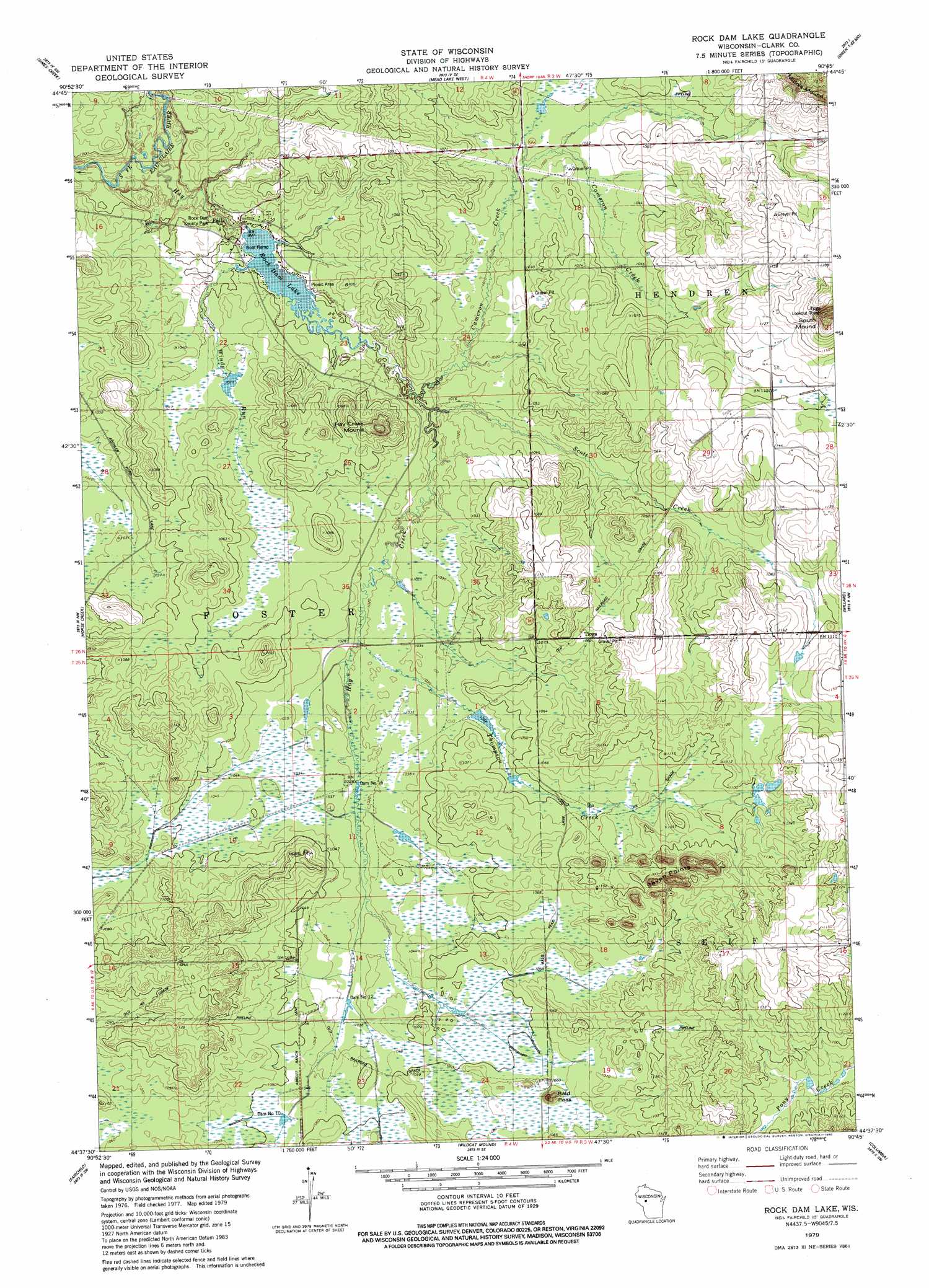
USGS Topo Quad 44090f7 - 1:24,000 scale
| Topo Map Name: | Rock Dam Lake |
| USGS Topo Quad ID: | 44090f7 |
| Print Size: | ca. 21 1/4" wide x 27" high |
| Southeast Coordinates: | 44.625° N latitude / 90.75° W longitude |
| Map Center Coordinates: | 44.6875° N latitude / 90.8125° W longitude |
| U.S. State: | WI |
| Filename: | o44090f7.jpg |
| Download Map JPG Image: | Rock Dam Lake topo map 1:24,000 scale |
| Map Type: | Topographic |
| Topo Series: | 7.5´ |
| Map Scale: | 1:24,000 |
| Source of Map Images: | United States Geological Survey (USGS) |
| Alternate Map Versions: |
Rock Dam Lake WI 1979, updated 1980 Download PDF Buy paper map Rock Dam Lake WI 2010 Download PDF Buy paper map Rock Dam Lake WI 2013 Download PDF Buy paper map Rock Dam Lake WI 2015 Download PDF Buy paper map |
1:24,000 Topo Quads surrounding Rock Dam Lake
Boyd |
Stanley |
Thorp |
Lombard |
Owen |
Lake Eau Claire East |
Simes Creek |
Mead Lake West |
Mead Lake East |
Greenwood |
Augusta East |
Horse Creek |
Rock Dam Lake |
Willard |
Loyal West |
Price |
Fairchild |
Wildcat Mound |
Columbia |
Neillsville |
Hixton |
Alma Center |
Merrillan |
Hatfield |
Hatfield Ne |
> Back to 44090e1 at 1:100,000 scale
> Back to 44090a1 at 1:250,000 scale
> Back to U.S. Topo Maps home
Rock Dam Lake topo map: Gazetteer
Rock Dam Lake: Dams
Clark County 16 Dam elevation 314m 1030′Clark County Number 10 G328 Dam elevation 319m 1046′
Dam Number Sixteen elevation 314m 1030′
Dam Number Ten elevation 318m 1043′
Dam Number Twelve elevation 315m 1033′
Rock 2WP297 Dam elevation 303m 994′
Rock Dam Lake: Lakes
Rock Dam Lake elevation 303m 994′Rock Dam Lake: Parks
Rock Dam County Park elevation 301m 987′Rock Dam Lake: Populated Places
Tioga elevation 329m 1079′Rock Dam Lake: Reservoirs
16 Reservoir elevation 314m 1030′Hay Creek Lake 59 elevation 303m 994′
Lake 22-13 elevation 319m 1046′
Rock Dam Lake: Ridges
Seven Points elevation 384m 1259′Rock Dam Lake: Streams
Cameron Creek elevation 305m 1000′Hay Creek elevation 293m 961′
Scott Creek elevation 305m 1000′
Thompson Creek elevation 311m 1020′
Windy Run elevation 305m 1000′
Rock Dam Lake: Summits
Bald Peak elevation 349m 1145′Hay Creek Mound elevation 353m 1158′
Rock Dam Lake digital topo map on disk
Buy this Rock Dam Lake topo map showing relief, roads, GPS coordinates and other geographical features, as a high-resolution digital map file on DVD: