Chippewa Falls Topo Map Wisconsin
To zoom in, hover over the map of Chippewa Falls
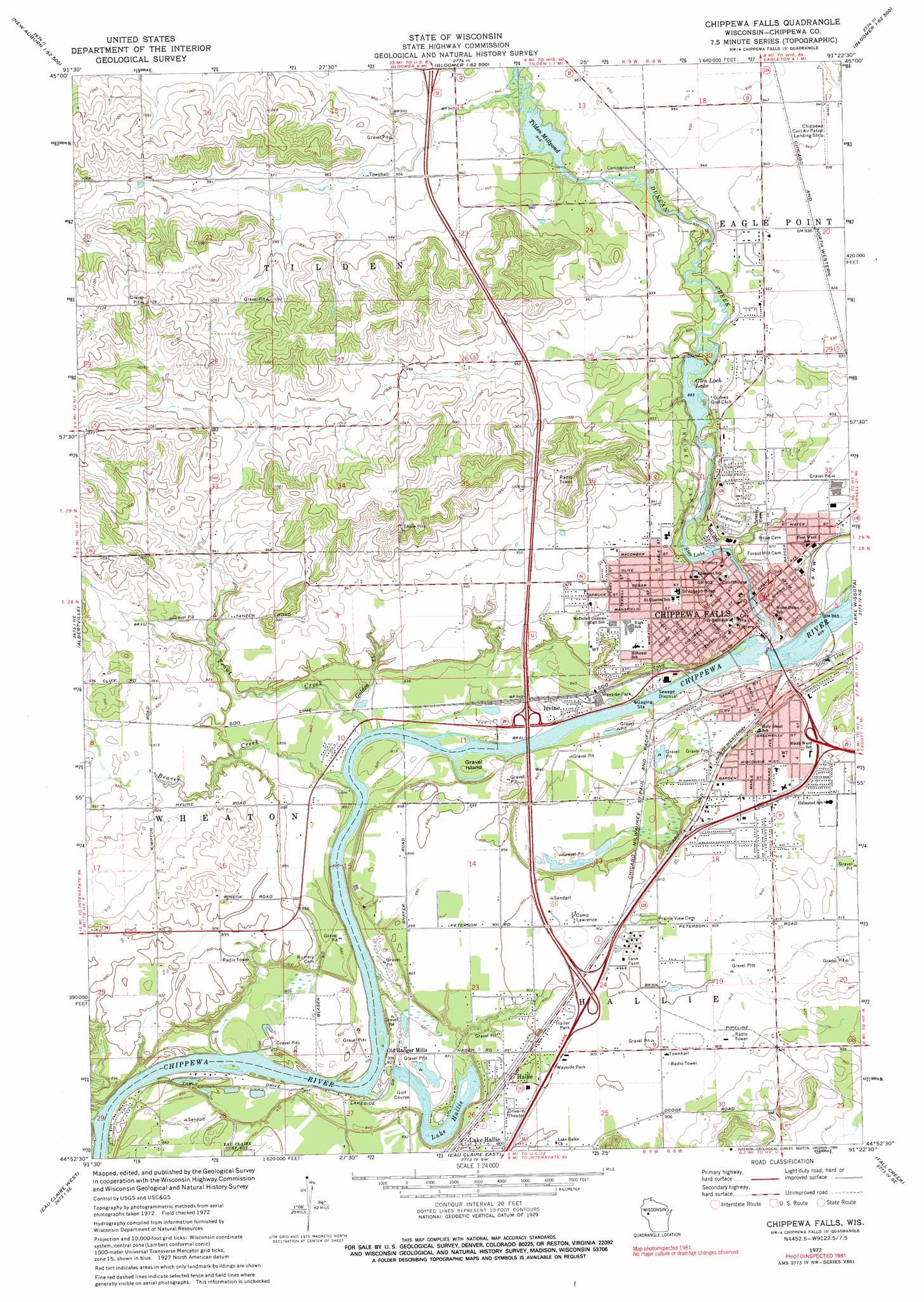
USGS Topo Quad 44091h4 - 1:24,000 scale
| Topo Map Name: | Chippewa Falls |
| USGS Topo Quad ID: | 44091h4 |
| Print Size: | ca. 21 1/4" wide x 27" high |
| Southeast Coordinates: | 44.875° N latitude / 91.375° W longitude |
| Map Center Coordinates: | 44.9375° N latitude / 91.4375° W longitude |
| U.S. State: | WI |
| Filename: | o44091h4.jpg |
| Download Map JPG Image: | Chippewa Falls topo map 1:24,000 scale |
| Map Type: | Topographic |
| Topo Series: | 7.5´ |
| Map Scale: | 1:24,000 |
| Source of Map Images: | United States Geological Survey (USGS) |
| Alternate Map Versions: |
Chippewa Falls WI 1972, updated 1975 Download PDF Buy paper map Chippewa Falls WI 1972, updated 1990 Download PDF Buy paper map Chippewa Falls WI 2010 Download PDF Buy paper map Chippewa Falls WI 2013 Download PDF Buy paper map Chippewa Falls WI 2015 Download PDF Buy paper map |
1:24,000 Topo Quads surrounding Chippewa Falls
Sand Creek |
New Auburn |
Marsh-Miller Lake |
Bob Lake |
Cornell |
Colfax North |
Como Creek |
Bloomer |
Jim Falls |
Crescent |
Colfax South |
Albertville |
Chippewa Falls |
Lake Wissota |
Cadott |
Elk Creek Lake |
Eau Claire West |
Eau Claire East |
Fall Creek |
Lake Eau Claire West |
Rock Falls |
Mondovi Ne |
Cleghorn |
Brackett |
Augusta West |
> Back to 44091e1 at 1:100,000 scale
> Back to 44090a1 at 1:250,000 scale
> Back to U.S. Topo Maps home
Chippewa Falls topo map: Gazetteer
Chippewa Falls: Dams
Chippewa Falls WP304 Dam elevation 256m 839′Glen Loch 2WP1095 Dam elevation 271m 889′
Lake Hallie 2WP502 Dam elevation 246m 807′
Tilden 2WP150 Dam elevation 281m 921′
Chippewa Falls: Islands
Gravel Island elevation 250m 820′Chippewa Falls: Parks
Irvine Park elevation 282m 925′Northern Wisconsin State Fairgrounds elevation 278m 912′
Chippewa Falls: Populated Places
Chippewa Falls elevation 256m 839′Hallie elevation 275m 902′
Irvine elevation 250m 820′
Lake Hallie elevation 272m 892′
Chippewa Falls: Post Offices
Chippewa Falls Post Office elevation 257m 843′Chippewa Falls: Reservoirs
Chippewa Falls Flowage 5555 elevation 256m 839′Glen Loch Flowage 116.5 elevation 272m 892′
Glen Lock Lake elevation 271m 889′
Lake Hallie elevation 246m 807′
Lake Hallie 2 elevation 244m 800′
Star Lake elevation 257m 843′
Tilden Millpond elevation 281m 921′
Tilden Millpond 110 elevation 281m 921′
Chippewa Falls: Streams
Beaver Creek elevation 245m 803′Duncan Creek elevation 248m 813′
Golden Creek elevation 250m 820′
Trout Creek elevation 244m 800′
Chippewa Falls digital topo map on disk
Buy this Chippewa Falls topo map showing relief, roads, GPS coordinates and other geographical features, as a high-resolution digital map file on DVD: