Douglas Topo Map Minnesota
To zoom in, hover over the map of Douglas
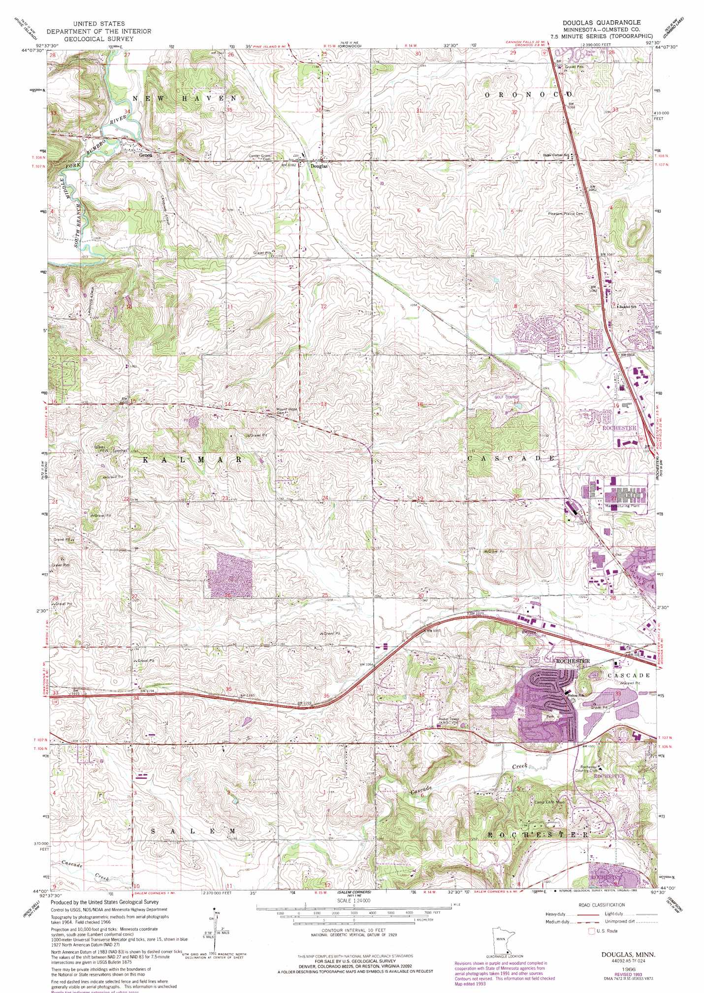
USGS Topo Quad 44092a5 - 1:24,000 scale
| Topo Map Name: | Douglas |
| USGS Topo Quad ID: | 44092a5 |
| Print Size: | ca. 21 1/4" wide x 27" high |
| Southeast Coordinates: | 44° N latitude / 92.5° W longitude |
| Map Center Coordinates: | 44.0625° N latitude / 92.5625° W longitude |
| U.S. State: | MN |
| Filename: | o44092a5.jpg |
| Download Map JPG Image: | Douglas topo map 1:24,000 scale |
| Map Type: | Topographic |
| Topo Series: | 7.5´ |
| Map Scale: | 1:24,000 |
| Source of Map Images: | United States Geological Survey (USGS) |
| Alternate Map Versions: |
Douglas MN 1966, updated 1967 Download PDF Buy paper map Douglas MN 1966, updated 1983 Download PDF Buy paper map Douglas MN 1966, updated 1993 Download PDF Buy paper map Douglas MN 2010 Download PDF Buy paper map Douglas MN 2013 Download PDF Buy paper map Douglas MN 2016 Download PDF Buy paper map |
1:24,000 Topo Quads surrounding Douglas
Wanamingo |
Zumbrota |
Mazeppa |
Zumbro Falls |
West Albany |
Concord |
Pine Island |
Oronoco |
Zumbro Lake |
Millville |
Dodge Center |
Byron |
Douglas |
Rochester |
Chester |
Hayfield |
Rock Dell |
Salem Corners |
Simpson |
Marion |
Sargeant |
High Forest Sw |
High Forest |
Stewartville |
Washington |
> Back to 44092a1 at 1:100,000 scale
> Back to 44092a1 at 1:250,000 scale
> Back to U.S. Topo Maps home
Douglas topo map: Gazetteer
Douglas: Airports
Minnesota Department of Transportation Heliport elevation 313m 1026′Douglas: Parks
Arborglen Park elevation 340m 1115′Diamond Ridge Park elevation 335m 1099′
Eagle Ridge Park elevation 342m 1122′
Fox Valley Park elevation 324m 1062′
Judd Park elevation 313m 1026′
Lincolnshire Park elevation 311m 1020′
Manor Park elevation 345m 1131′
Mohn Park elevation 310m 1017′
North Park elevation 338m 1108′
Northwest Prairie Park elevation 315m 1033′
Second Frank Canine Park elevation 312m 1023′
Wedgewood Hills Park elevation 338m 1108′
White Oaks Park elevation 337m 1105′
Woodside Park elevation 338m 1108′
Younge Park elevation 368m 1207′
Douglas: Populated Places
Douglas elevation 330m 1082′Genoa elevation 307m 1007′
Oronoco Estates elevation 311m 1020′
Douglas: Post Offices
Douglas Post Office (historical) elevation 330m 1082′Genoa Post Office (historical) elevation 307m 1007′
Douglas: Reservoirs
Cascade Lake elevation 305m 1000′Douglas digital topo map on disk
Buy this Douglas topo map showing relief, roads, GPS coordinates and other geographical features, as a high-resolution digital map file on DVD: