Wabasha South Topo Map Minnesota
To zoom in, hover over the map of Wabasha South
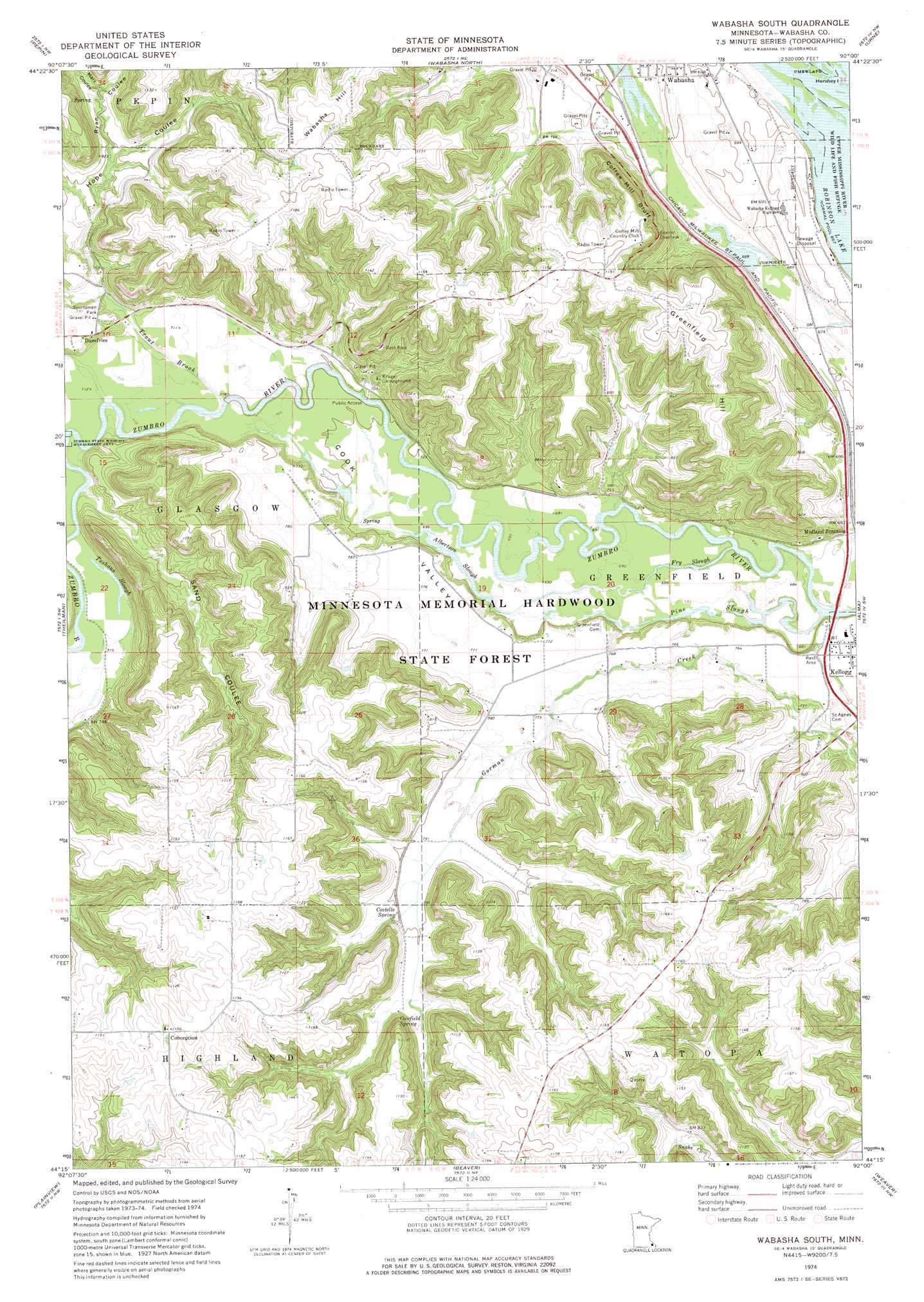
USGS Topo Quad 44092c1 - 1:24,000 scale
| Topo Map Name: | Wabasha South |
| USGS Topo Quad ID: | 44092c1 |
| Print Size: | ca. 21 1/4" wide x 27" high |
| Southeast Coordinates: | 44.25° N latitude / 92° W longitude |
| Map Center Coordinates: | 44.3125° N latitude / 92.0625° W longitude |
| U.S. State: | MN |
| Filename: | o44092c1.jpg |
| Download Map JPG Image: | Wabasha South topo map 1:24,000 scale |
| Map Type: | Topographic |
| Topo Series: | 7.5´ |
| Map Scale: | 1:24,000 |
| Source of Map Images: | United States Geological Survey (USGS) |
| Alternate Map Versions: |
Wabasha South MN 1974, updated 1976 Download PDF Buy paper map Wabasha South MN 2010 Download PDF Buy paper map Wabasha South MN 2013 Download PDF Buy paper map Wabasha South MN 2016 Download PDF Buy paper map |
1:24,000 Topo Quads surrounding Wabasha South
Maiden Rock |
Nerike Hill |
Ella |
Durand South |
Tarrant |
Lake City |
Pepin |
Wabasha North |
Urne |
Modena |
West Albany |
Theilman |
Wabasha South |
Alma |
Cream |
Millville |
Plainview |
Beaver |
Weaver |
Cochrane |
Chester |
Plainview Sw |
Elba |
Altura |
Rollingstone |
> Back to 44092a1 at 1:100,000 scale
> Back to 44092a1 at 1:250,000 scale
> Back to U.S. Topo Maps home
Wabasha South topo map: Gazetteer
Wabasha South: Dams
C Jordan Dam elevation 260m 853′Peter Drysdale Dam elevation 256m 839′
Schouweiller-Speedling Dam elevation 343m 1125′
Sheehan-Stork Dam elevation 294m 964′
Wabasha South: Flats
Cook Valley elevation 229m 751′Wabasha South: Guts
Albertson Slough elevation 212m 695′Fry Slough elevation 207m 679′
Pine Slough elevation 207m 679′
Tushaus Slough elevation 218m 715′
Wabasha South: Parks
Wabasha Overlook elevation 295m 967′Wabasha South: Populated Places
Conception elevation 356m 1167′Dumfries elevation 240m 787′
Midland Junction elevation 213m 698′
Wabasha South: Post Offices
Conception Post Office (historical) elevation 356m 1167′Dumfries Post Office (historical) elevation 239m 784′
Wabasha South: Springs
Canfield Spring elevation 251m 823′Costello Spring elevation 245m 803′
Wabasha South: Streams
Trout Brook elevation 215m 705′Wabasha South: Summits
Greenfield Hill elevation 378m 1240′Wabasha Hill elevation 366m 1200′
Wabasha South: Valleys
Hope Coulee elevation 223m 731′Marx Coulee elevation 246m 807′
Ryan Coulee elevation 237m 777′
Sand Coulee elevation 218m 715′
Wabasha South digital topo map on disk
Buy this Wabasha South topo map showing relief, roads, GPS coordinates and other geographical features, as a high-resolution digital map file on DVD: