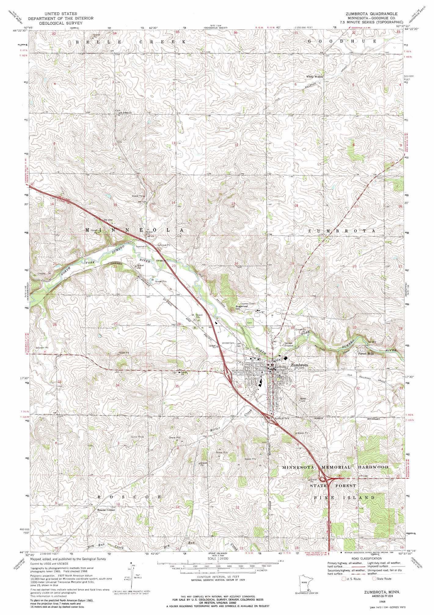
Zumbrota Topo Map Minnesota
To zoom in, hover over the map of Zumbrota
USGS Topo Quad 44092c6 - 1:24,000 scale
| Topo Map Name: | Zumbrota |
| USGS Topo Quad ID: | 44092c6 |
| Print Size: | ca. 21 1/4" wide x 27" high |
| Southeast Coordinates: | 44.25° N latitude / 92.625° W longitude |
| Map Center Coordinates: | 44.3125° N latitude / 92.6875° W longitude |
| U.S. State: | MN |
| Filename: | o44092c6.jpg |
| Download Map JPG Image: | Zumbrota topo map 1:24,000 scale |
| Map Type: | Topographic |
| Topo Series: | 7.5´ |
| Map Scale: | 1:24,000 |
| Source of Map Images: | United States Geological Survey (USGS) |
| Alternate Map Versions: |
Zumbrota MN 1968, updated 1970 Download PDF Buy paper map Zumbrota MN 1968, updated 1986 Download PDF Buy paper map Zumbrota MN 2010 Download PDF Buy paper map Zumbrota MN 2013 Download PDF Buy paper map Zumbrota MN 2016 Download PDF Buy paper map |
1:24,000 Topo Quads surrounding Zumbrota
Cannon Falls |
Miesville |
Welch |
Red Wing |
Bay City |
Sogn |
White Rock |
Goodhue West |
Goodhue East |
Lake City Nw |
Kenyon |
Wanamingo |
Zumbrota |
Mazeppa |
Zumbro Falls |
West Concord |
Concord |
Pine Island |
Oronoco |
Zumbro Lake |
Claremont |
Dodge Center |
Byron |
Douglas |
Rochester |
> Back to 44092a1 at 1:100,000 scale
> Back to 44092a1 at 1:250,000 scale
> Back to U.S. Topo Maps home
Zumbrota topo map: Gazetteer
Zumbrota: Bridges
Covered Bridge elevation 299m 980′Zumbrota: Dams
Erredge Group Detention Dam elevation 328m 1076′Joseph Frederich Dam elevation 358m 1174′
Lower 7 Group Structure Number 1 Dam elevation 327m 1072′
Lower 7 Group Structure Number 2 Dam elevation 329m 1079′
Minneola Township Pool Site 3 Dam elevation 362m 1187′
Thomforde Group Structure Number 1 Dam elevation 317m 1040′
Thomforde-Rockne Number 1 Dam elevation 341m 1118′
Thomforde-Rockne Number 2 Dam elevation 336m 1102′
Zumbrota: Parks
Zumbrota Historical Marker elevation 318m 1043′Zumbrota Wayside Park elevation 318m 1043′
Zumbrota: Populated Places
Forest Mills elevation 308m 1010′Roscoe Center elevation 370m 1213′
White Willow elevation 334m 1095′
Zumbrota elevation 302m 990′
Zumbrota: Post Offices
Forest Mills Post Office (historical) elevation 308m 1010′Roscoe Center Post Office (historical) elevation 370m 1213′
Whitewillow Post Office (historical) elevation 335m 1099′
Zumbrota Post Office elevation 302m 990′
Zumbrota: Streams
Bitter Creek elevation 292m 958′Zumbrota: Summits
Sugarloaf Hill elevation 328m 1076′Zumbrota digital topo map on disk
Buy this Zumbrota topo map showing relief, roads, GPS coordinates and other geographical features, as a high-resolution digital map file on DVD: