Red Wing Topo Map Minnesota
To zoom in, hover over the map of Red Wing
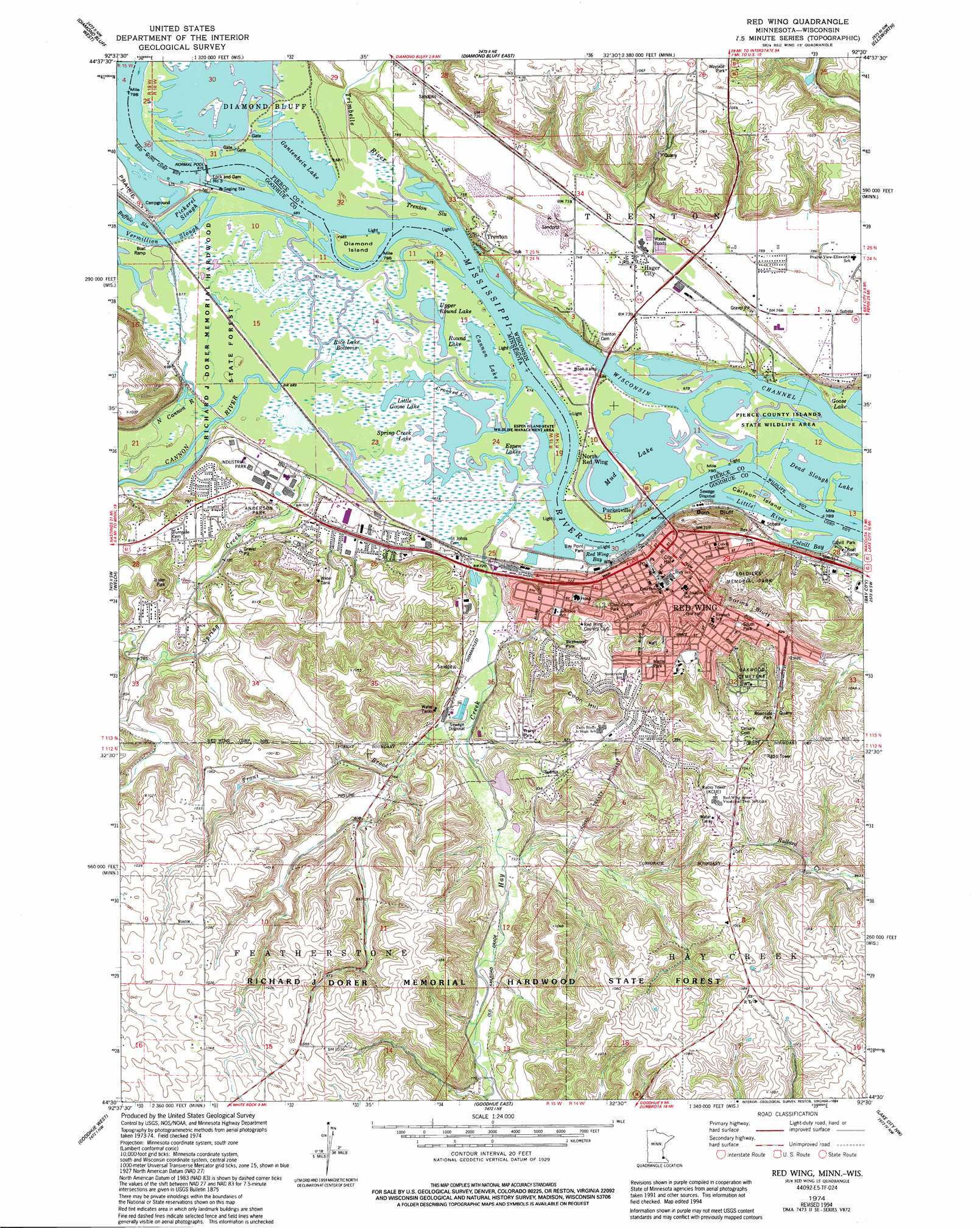
USGS Topo Quad 44092e5 - 1:24,000 scale
| Topo Map Name: | Red Wing |
| USGS Topo Quad ID: | 44092e5 |
| Print Size: | ca. 21 1/4" wide x 27" high |
| Southeast Coordinates: | 44.5° N latitude / 92.5° W longitude |
| Map Center Coordinates: | 44.5625° N latitude / 92.5625° W longitude |
| U.S. States: | MN, WI |
| Filename: | o44092e5.jpg |
| Download Map JPG Image: | Red Wing topo map 1:24,000 scale |
| Map Type: | Topographic |
| Topo Series: | 7.5´ |
| Map Scale: | 1:24,000 |
| Source of Map Images: | United States Geological Survey (USGS) |
| Alternate Map Versions: |
Red Wing MN 1974, updated 1978 Download PDF Buy paper map Red Wing MN 1974, updated 1994 Download PDF Buy paper map Red Wing MN 2010 Download PDF Buy paper map Red Wing MN 2013 Download PDF Buy paper map Red Wing MN 2016 Download PDF Buy paper map |
1:24,000 Topo Quads surrounding Red Wing
Prescott |
River Falls West |
River Falls East |
Martell |
El Paso |
Hastings |
Diamond Bluff West |
Diamond Bluff East |
Ellsworth |
Waverly |
Miesville |
Welch |
Red Wing |
Bay City |
Maiden Rock |
White Rock |
Goodhue West |
Goodhue East |
Lake City Nw |
Lake City |
Wanamingo |
Zumbrota |
Mazeppa |
Zumbro Falls |
West Albany |
> Back to 44092e1 at 1:100,000 scale
> Back to 44092a1 at 1:250,000 scale
> Back to U.S. Topo Maps home
Red Wing topo map: Gazetteer
Red Wing: Bays
Colvill Bay elevation 203m 666′Red Wing Bay elevation 203m 666′
Red Wing: Bridges
Dwight D Eisenhower Bridge elevation 205m 672′Red Wing: Channels
Little River elevation 203m 666′Wisconsin Channel elevation 203m 666′
Red Wing: Cliffs
Barn Bluff elevation 223m 731′Sorins Bluff elevation 276m 905′
Red Wing: Dams
Arthur Voth Detention Dam elevation 275m 902′Bay City 1 D8943 Dam elevation 260m 853′
Bullard Creek Number 6 Dam elevation 300m 984′
Bullard Creek Structure 1 Dam elevation 300m 984′
Bullard Creek Structure 2 Dam elevation 300m 984′
Dam Number Three elevation 207m 679′
Elmer Voth Detention Dam elevation 307m 1007′
Lock and Dam Number 3 elevation 204m 669′
Lock and Dam Number Three elevation 204m 669′
Red Wing: Guts
Buffalo Slough elevation 203m 666′Pickerel Slough elevation 203m 666′
Trenton Slough elevation 203m 666′
Red Wing: Islands
Carlson Island elevation 203m 666′Diamond Island elevation 207m 679′
Red Wing: Lakes
Cannon Lake elevation 203m 666′Devils Lake elevation 209m 685′
Espen Lakes elevation 203m 666′
Little Goose Lake elevation 203m 666′
Mud Lake elevation 204m 669′
Round Lake elevation 203m 666′
Spring Creek Lake elevation 206m 675′
Upper Round Lake elevation 203m 666′
Red Wing: Parks
Anderson Park elevation 242m 793′Audrey - Grandview Park elevation 264m 866′
Barn Bluff Historical Marker elevation 285m 935′
Barn Bluff Park elevation 285m 935′
Bay Point Park elevation 207m 679′
Bevans Circle - Pine Ridge Park elevation 302m 990′
Billings Tomfohr Conservation Area elevation 309m 1013′
Birchwood Park elevation 241m 790′
Bluffview Park elevation 211m 692′
Cannonview Park elevation 240m 787′
Central Park elevation 287m 941′
Civic Center Park elevation 277m 908′
Colvill Park elevation 207m 679′
Espen Island State Wildlife Management Area elevation 204m 669′
Featherstone Park elevation 228m 748′
Gadient Heights Park elevation 250m 820′
Hi Park Playground elevation 324m 1062′
John Rich Park elevation 274m 898′
Jordan Court Park elevation 217m 711′
LaGrange Park elevation 270m 885′
Levee Park elevation 211m 692′
Martha Lane Park elevation 244m 800′
Pierce County Islands State Public Hunting Grounds elevation 204m 669′
Pine Valley Park elevation 272m 892′
Pottery Pond Park elevation 245m 803′
Red Wing Region Historical Marker elevation 313m 1026′
Red Wing Wayside Park elevation 279m 915′
Sandy Lane Park elevation 249m 816′
Soldiers Memorial Park elevation 315m 1033′
South Park elevation 246m 807′
Spring Creek Park elevation 229m 751′
Sun Valley Park elevation 256m 839′
Sunnyside/Roosevelt Park elevation 267m 875′
Trenton Bluff Prairie State Natural Area elevation 297m 974′
William Colvill Historical Marker elevation 207m 679′
Woodland Park elevation 244m 800′
Red Wing: Populated Places
Grand View Mobile Park elevation 272m 892′Hager City elevation 219m 718′
North Red Wing elevation 207m 679′
Pepin Woods Mobile Home Park elevation 250m 820′
Pucketville elevation 207m 679′
Red Wing elevation 226m 741′
Trenton elevation 236m 774′
Red Wing: Post Offices
Red Wing Post Office elevation 218m 715′Red Wing: Reservoirs
4 Reservoir elevation 260m 853′Gantenbein Lake elevation 207m 679′
Pool 3 elevation 204m 669′
Red Wing: Streams
Cannon River elevation 203m 666′Crooked Creek elevation 203m 666′
Hay Creek elevation 203m 666′
North Cannon River elevation 207m 679′
Spring Creek elevation 203m 666′
Trimbelle River elevation 203m 666′
Trout Brook elevation 212m 695′
Vermillion Slough elevation 203m 666′
Red Wing: Summits
Coon Hill elevation 320m 1049′Red Wing: Swamps
Rice Lake Bottoms elevation 207m 679′Red Wing digital topo map on disk
Buy this Red Wing topo map showing relief, roads, GPS coordinates and other geographical features, as a high-resolution digital map file on DVD: