Spring Valley Topo Map Wisconsin
To zoom in, hover over the map of Spring Valley
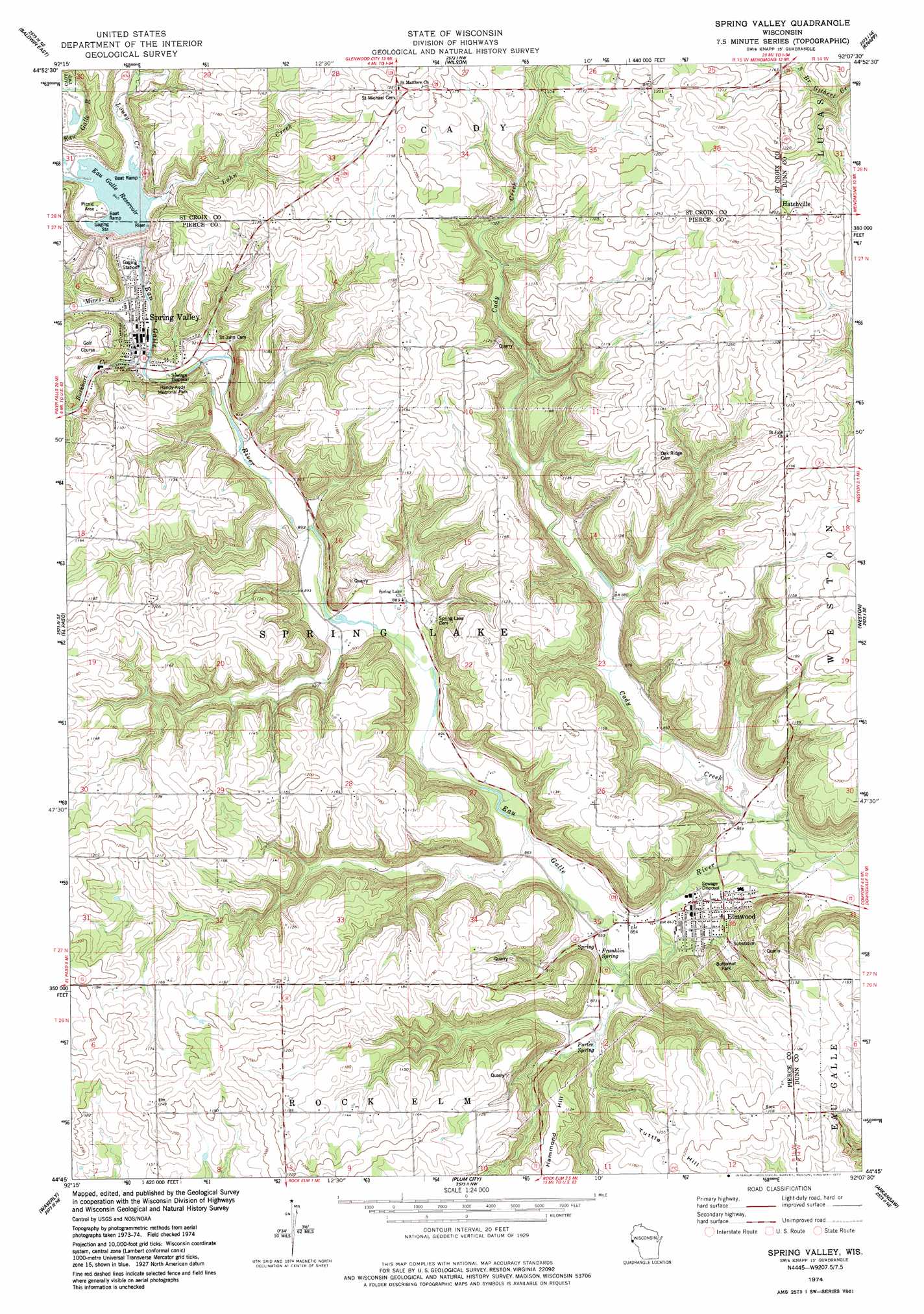
USGS Topo Quad 44092g2 - 1:24,000 scale
| Topo Map Name: | Spring Valley |
| USGS Topo Quad ID: | 44092g2 |
| Print Size: | ca. 21 1/4" wide x 27" high |
| Southeast Coordinates: | 44.75° N latitude / 92.125° W longitude |
| Map Center Coordinates: | 44.8125° N latitude / 92.1875° W longitude |
| U.S. State: | WI |
| Filename: | o44092g2.jpg |
| Download Map JPG Image: | Spring Valley topo map 1:24,000 scale |
| Map Type: | Topographic |
| Topo Series: | 7.5´ |
| Map Scale: | 1:24,000 |
| Source of Map Images: | United States Geological Survey (USGS) |
| Alternate Map Versions: |
Spring Valley WI 1974, updated 1977 Download PDF Buy paper map Spring Valley WI 2010 Download PDF Buy paper map Spring Valley WI 2013 Download PDF Buy paper map Spring Valley WI 2015 Download PDF Buy paper map |
1:24,000 Topo Quads surrounding Spring Valley
Jewett |
Emerald |
Glenwood City |
Boyceville |
Wheeler |
Baldwin West |
Baldwin East |
Wilson |
Knapp |
Menomonie North |
Martell |
El Paso |
Spring Valley |
Weston |
Menomonie South |
Ellsworth |
Waverly |
Plum City |
Arkansaw |
Durand North |
Bay City |
Maiden Rock |
Nerike Hill |
Ella |
Durand South |
> Back to 44092e1 at 1:100,000 scale
> Back to 44092a1 at 1:250,000 scale
> Back to U.S. Topo Maps home
Spring Valley topo map: Gazetteer
Spring Valley: Dams
Eau Galle E30.184 Dam elevation 288m 944′Spring Valley: Parks
Butternut Park elevation 270m 885′Handy-Andy Memorial Park elevation 276m 905′
Spring Valley: Populated Places
Elmwood elevation 262m 859′Hatchville elevation 368m 1207′
Spring Valley elevation 277m 908′
Spring Valley: Reservoirs
Lake George elevation 288m 944′Spring Valley Lake 64 elevation 288m 944′
Spring Valley: Springs
Eagle Spring elevation 311m 1020′Franklin Spring elevation 258m 846′
Porter Spring elevation 264m 866′
Spring Valley: Streams
Burkhart Creek elevation 278m 912′Cady Creek elevation 250m 820′
Lohn Creek elevation 288m 944′
Lousy Creek elevation 288m 944′
Mines Creek elevation 280m 918′
Spring Valley: Summits
Hammond Hill elevation 342m 1122′Tuttle Hill elevation 372m 1220′
Spring Valley digital topo map on disk
Buy this Spring Valley topo map showing relief, roads, GPS coordinates and other geographical features, as a high-resolution digital map file on DVD: