Meriden Topo Map Minnesota
To zoom in, hover over the map of Meriden
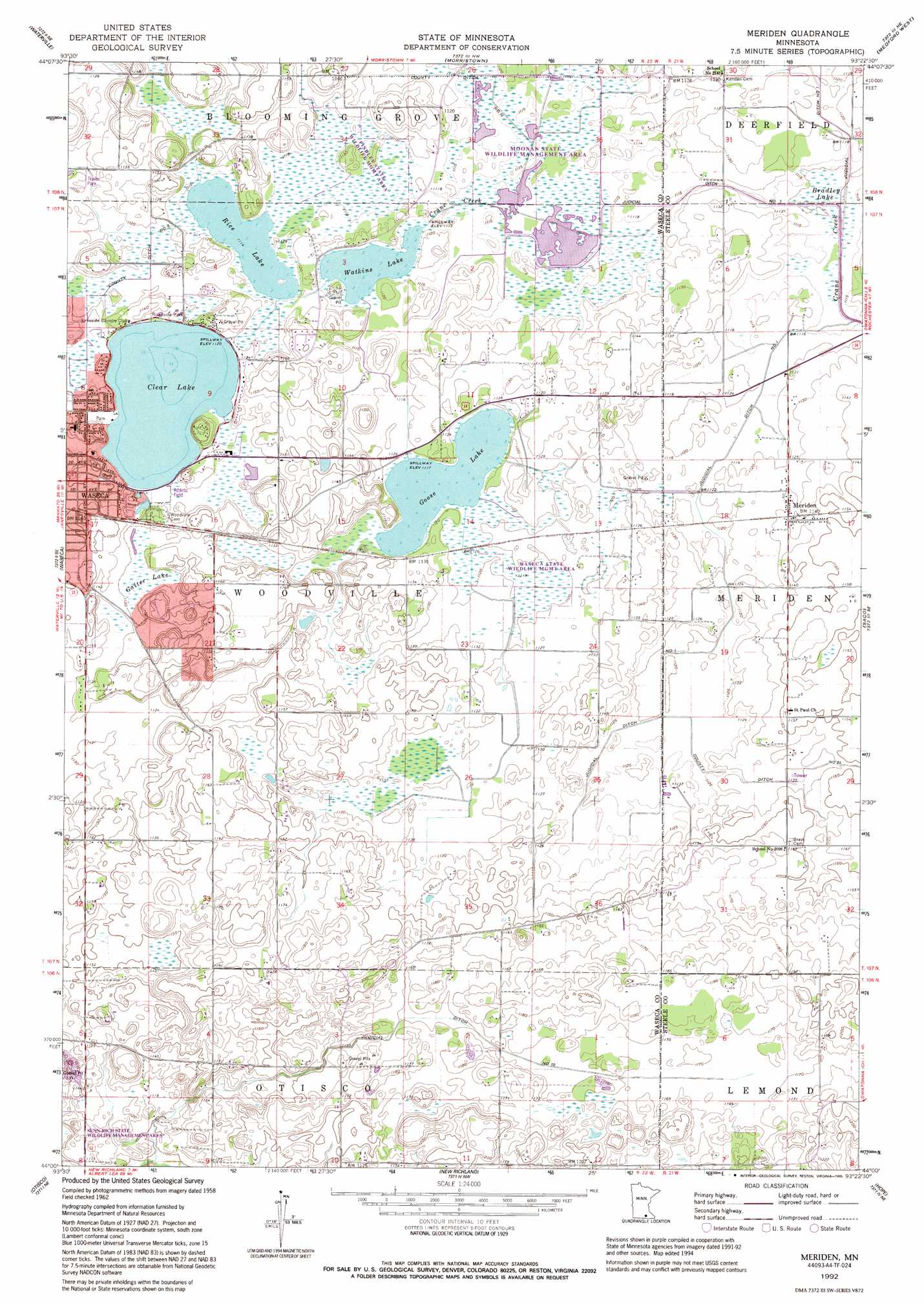
USGS Topo Quad 44093a4 - 1:24,000 scale
| Topo Map Name: | Meriden |
| USGS Topo Quad ID: | 44093a4 |
| Print Size: | ca. 21 1/4" wide x 27" high |
| Southeast Coordinates: | 44° N latitude / 93.375° W longitude |
| Map Center Coordinates: | 44.0625° N latitude / 93.4375° W longitude |
| U.S. State: | MN |
| Filename: | o44093a4.jpg |
| Download Map JPG Image: | Meriden topo map 1:24,000 scale |
| Map Type: | Topographic |
| Topo Series: | 7.5´ |
| Map Scale: | 1:24,000 |
| Source of Map Images: | United States Geological Survey (USGS) |
| Alternate Map Versions: |
Meriden MN 1962, updated 1964 Download PDF Buy paper map Meriden MN 1992, updated 1995 Download PDF Buy paper map Meriden MN 2010 Download PDF Buy paper map Meriden MN 2013 Download PDF Buy paper map Meriden MN 2016 Download PDF Buy paper map |
1:24,000 Topo Quads surrounding Meriden
Cordova |
Kilkenny |
Shieldsville |
Faribault |
Cannon City |
Elysian |
Waterville |
Morristown |
Medford West |
Medford East |
Janesville |
Waseca |
Meriden |
Saco |
Owatonna |
Waldorf |
Otisco |
New Richland |
Hope |
Steele Center |
Matawan |
Freeborn |
Hartland |
Ellendale |
Hollandale |
> Back to 44093a1 at 1:100,000 scale
> Back to 44092a1 at 1:250,000 scale
> Back to U.S. Topo Maps home
Meriden topo map: Gazetteer
Meriden: Canals
County Ditch Number Eleven elevation 339m 1112′County Ditch Number Nine elevation 341m 1118′
Judicial Ditch Number Ten elevation 354m 1161′
Meriden: Dams
Watkins Lake Dam elevation 340m 1115′Meriden: Lakes
Rice Lake elevation 340m 1115′Meriden: Parks
Clear Lake Park elevation 345m 1131′Emerson Park elevation 350m 1148′
Findley State Wildlife Management Area elevation 340m 1115′
Maplewood Park elevation 354m 1161′
Memorial Park elevation 344m 1128′
Moonan State Wildlife Management Area elevation 339m 1112′
Oak Park elevation 351m 1151′
Southview Park elevation 350m 1148′
Sportsmans Park elevation 342m 1122′
Waseca State Wildlife Management Area elevation 341m 1118′
Meriden: Populated Places
Meriden elevation 346m 1135′Meriden: Post Offices
Meriden Post Office elevation 346m 1135′Meriden: Reservoirs
Clear Lake elevation 341m 1118′Goose Lake elevation 341m 1118′
Watkins Lake elevation 340m 1115′
Meriden: Swamps
Bradley Lake elevation 338m 1108′Gaiter Lake elevation 343m 1125′
Meriden digital topo map on disk
Buy this Meriden topo map showing relief, roads, GPS coordinates and other geographical features, as a high-resolution digital map file on DVD: