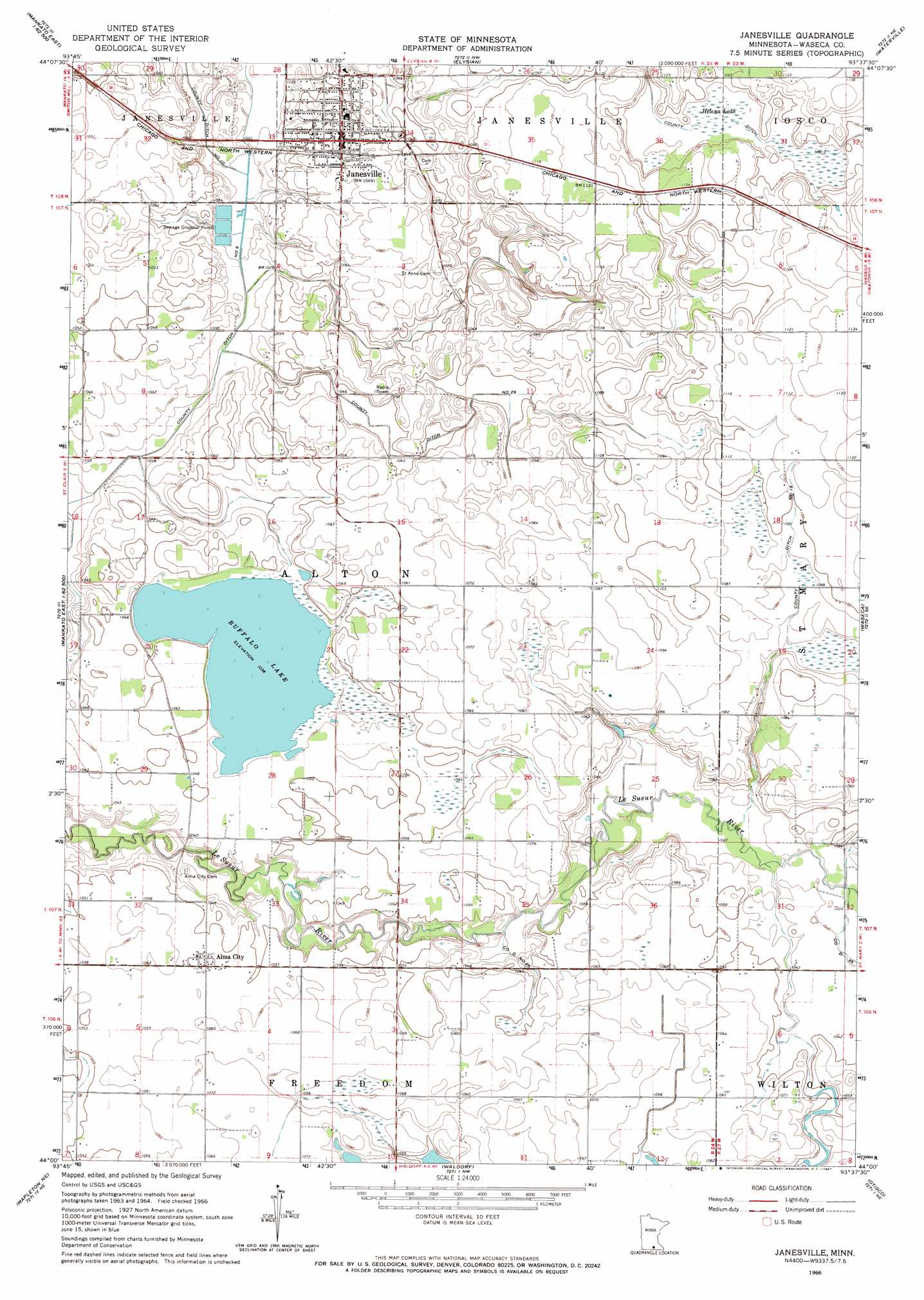
Janesville Topo Map Minnesota
To zoom in, hover over the map of Janesville
USGS Topo Quad 44093a6 - 1:24,000 scale
| Topo Map Name: | Janesville |
| USGS Topo Quad ID: | 44093a6 |
| Print Size: | ca. 21 1/4" wide x 27" high |
| Southeast Coordinates: | 44° N latitude / 93.625° W longitude |
| Map Center Coordinates: | 44.0625° N latitude / 93.6875° W longitude |
| U.S. State: | MN |
| Filename: | o44093a6.jpg |
| Download Map JPG Image: | Janesville topo map 1:24,000 scale |
| Map Type: | Topographic |
| Topo Series: | 7.5´ |
| Map Scale: | 1:24,000 |
| Source of Map Images: | United States Geological Survey (USGS) |
| Alternate Map Versions: |
Janesville MN 1966, updated 1967 Download PDF Buy paper map Janesville MN 2010 Download PDF Buy paper map Janesville MN 2013 Download PDF Buy paper map Janesville MN 2016 Download PDF Buy paper map |
1:24,000 Topo Quads surrounding Janesville
Saint Peter |
Cleveland |
Cordova |
Kilkenny |
Shieldsville |
Mankato East |
Madison Lake |
Elysian |
Waterville |
Morristown |
Beauford |
Saint Clair |
Janesville |
Waseca |
Meriden |
Mapleton |
Mapleton Ne |
Waldorf |
Otisco |
New Richland |
Easton |
Minnesota Lake |
Matawan |
Freeborn |
Hartland |
> Back to 44093a1 at 1:100,000 scale
> Back to 44092a1 at 1:250,000 scale
> Back to U.S. Topo Maps home
Janesville topo map: Gazetteer
Janesville: Canals
County Ditch Number Ninteen elevation 332m 1089′County Ditch Number Six elevation 309m 1013′
County Ditch Number Ten elevation 311m 1020′
County Ditch Number Three elevation 329m 1079′
County Ditch Number Twentyeight elevation 315m 1033′
County Ditch Number Twentynine elevation 319m 1046′
Janesville: Dams
Buffalo Lake Dam elevation 317m 1040′Janesville: Lakes
Buffalo Lake elevation 316m 1036′Janesville: Parks
North Street Park elevation 317m 1040′Veterans Memorial Park elevation 323m 1059′
Janesville: Populated Places
Alma City elevation 323m 1059′Janesville elevation 325m 1066′
Janesville: Post Offices
Alma City Post Office (historical) elevation 323m 1059′Janesville Post Office elevation 326m 1069′
Janesville: Reservoirs
Buffalo Lake elevation 317m 1040′Janesville: Swamps
Helena Lake elevation 331m 1085′Janesville digital topo map on disk
Buy this Janesville topo map showing relief, roads, GPS coordinates and other geographical features, as a high-resolution digital map file on DVD: