Montgomery Topo Map Minnesota
To zoom in, hover over the map of Montgomery
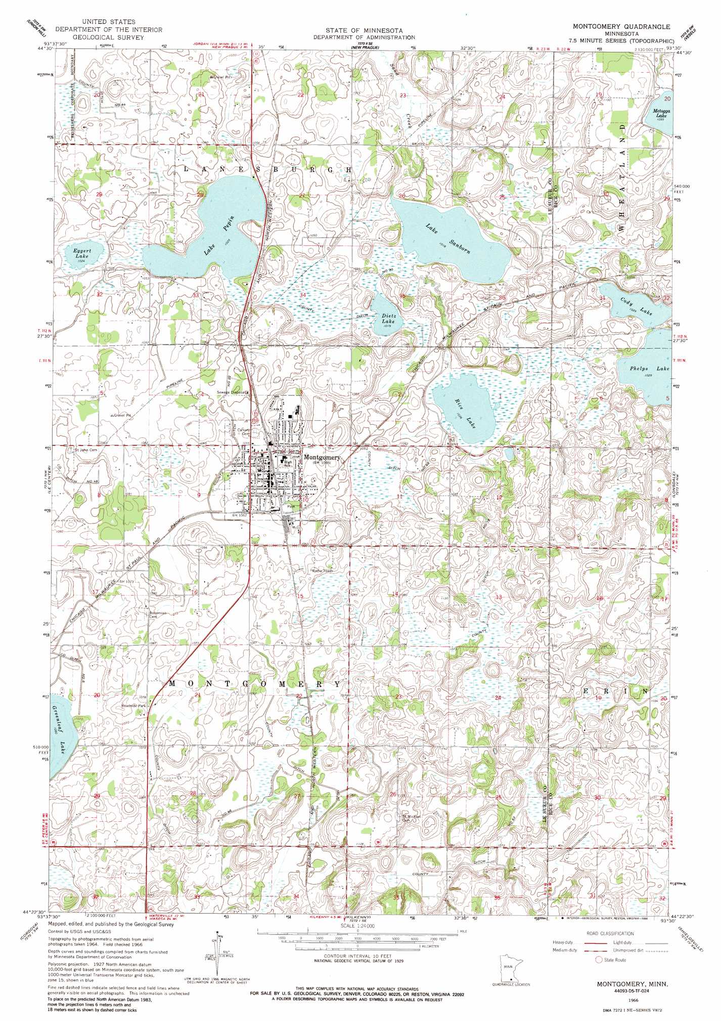
USGS Topo Quad 44093d5 - 1:24,000 scale
| Topo Map Name: | Montgomery |
| USGS Topo Quad ID: | 44093d5 |
| Print Size: | ca. 21 1/4" wide x 27" high |
| Southeast Coordinates: | 44.375° N latitude / 93.5° W longitude |
| Map Center Coordinates: | 44.4375° N latitude / 93.5625° W longitude |
| U.S. State: | MN |
| Filename: | o44093d5.jpg |
| Download Map JPG Image: | Montgomery topo map 1:24,000 scale |
| Map Type: | Topographic |
| Topo Series: | 7.5´ |
| Map Scale: | 1:24,000 |
| Source of Map Images: | United States Geological Survey (USGS) |
| Alternate Map Versions: |
Montgomery MN 1966, updated 1967 Download PDF Buy paper map Montgomery MN 1966, updated 1986 Download PDF Buy paper map Montgomery MN 2010 Download PDF Buy paper map Montgomery MN 2013 Download PDF Buy paper map Montgomery MN 2016 Download PDF Buy paper map |
1:24,000 Topo Quads surrounding Montgomery
Belle Plaine North |
Jordan West |
Jordan East |
Prior Lake |
Orchard Lake |
Belle Plaine South |
Union Hill |
New Prague |
Veseli |
New Market |
Saint Thomas |
Le Center |
Montgomery |
Lonsdale |
Little Chicago |
Cleveland |
Cordova |
Kilkenny |
Shieldsville |
Faribault |
Madison Lake |
Elysian |
Waterville |
Morristown |
Medford West |
> Back to 44093a1 at 1:100,000 scale
> Back to 44092a1 at 1:250,000 scale
> Back to U.S. Topo Maps home
Montgomery topo map: Gazetteer
Montgomery: Canals
County Ditch Number Eighteen elevation 324m 1062′County Ditch Number Forty elevation 319m 1046′
County Ditch Number Fortyfive elevation 317m 1040′
County Ditch Number Fortyfour elevation 311m 1020′
County Ditch Number Fortysix elevation 323m 1059′
County Ditch Number Sixtythree elevation 323m 1059′
County Ditch Number Thirty elevation 311m 1020′
County Ditch Number Twentytwo elevation 319m 1046′
Montgomery: Lakes
Dietz Lake elevation 310m 1017′Eggert Lake elevation 313m 1026′
Lake Pepin elevation 312m 1023′
Lake Sanborn elevation 310m 1017′
Metogga Lake elevation 334m 1095′
Phelps Lake elevation 312m 1023′
Rice Lake elevation 312m 1023′
Montgomery: Parks
Memorial Park elevation 326m 1069′Montgomery Wayside Park elevation 328m 1076′
Northside Park elevation 329m 1079′
Montgomery: Populated Places
Montgomery elevation 326m 1069′Montgomery: Post Offices
Montgomery Post Office elevation 326m 1069′Montgomery digital topo map on disk
Buy this Montgomery topo map showing relief, roads, GPS coordinates and other geographical features, as a high-resolution digital map file on DVD: