Le Center Topo Map Minnesota
To zoom in, hover over the map of Le Center
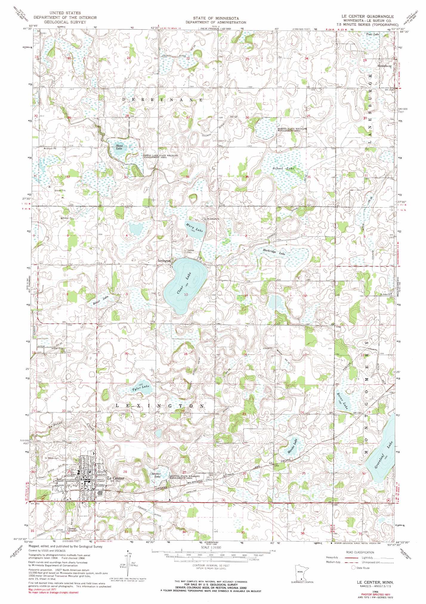
USGS Topo Quad 44093d6 - 1:24,000 scale
| Topo Map Name: | Le Center |
| USGS Topo Quad ID: | 44093d6 |
| Print Size: | ca. 21 1/4" wide x 27" high |
| Southeast Coordinates: | 44.375° N latitude / 93.625° W longitude |
| Map Center Coordinates: | 44.4375° N latitude / 93.6875° W longitude |
| U.S. State: | MN |
| Filename: | o44093d6.jpg |
| Download Map JPG Image: | Le Center topo map 1:24,000 scale |
| Map Type: | Topographic |
| Topo Series: | 7.5´ |
| Map Scale: | 1:24,000 |
| Source of Map Images: | United States Geological Survey (USGS) |
| Alternate Map Versions: |
Le Center MN 1966, updated 1968 Download PDF Buy paper map Le Center MN 1966, updated 1991 Download PDF Buy paper map Le Center MN 2010 Download PDF Buy paper map Le Center MN 2013 Download PDF Buy paper map Le Center MN 2016 Download PDF Buy paper map |
1:24,000 Topo Quads surrounding Le Center
Hamburg |
Belle Plaine North |
Jordan West |
Jordan East |
Prior Lake |
Henderson |
Belle Plaine South |
Union Hill |
New Prague |
Veseli |
Le Sueur |
Saint Thomas |
Le Center |
Montgomery |
Lonsdale |
Saint Peter |
Cleveland |
Cordova |
Kilkenny |
Shieldsville |
Mankato East |
Madison Lake |
Elysian |
Waterville |
Morristown |
> Back to 44093a1 at 1:100,000 scale
> Back to 44092a1 at 1:250,000 scale
> Back to U.S. Topo Maps home
Le Center topo map: Gazetteer
Le Center: Canals
County Ditch Number Fortyeight elevation 314m 1030′County Ditch Number Fortyfive elevation 307m 1007′
County Ditch Number Fortythree elevation 309m 1013′
County Ditch Number Fortytwo elevation 309m 1013′
County Ditch Number Six elevation 321m 1053′
County Ditch Number Sixteen elevation 318m 1043′
County Ditch Number Twentynine elevation 308m 1010′
County Ditch Number Twentyone elevation 311m 1020′
County Ditch Number Twentysix elevation 315m 1033′
County Ditch Number Twentythree elevation 310m 1017′
Le Center: Lakes
Borer Lake elevation 321m 1053′Clear Lake elevation 305m 1000′
Greenleaf Lake elevation 320m 1049′
Harkridge Lake elevation 307m 1007′
Mareks Lake elevation 318m 1043′
Mary Lake elevation 303m 994′
Sautter Lake elevation 306m 1003′
School Lake elevation 313m 1026′
Sheas Lake elevation 305m 1000′
Tyler Lake elevation 312m 1023′
Le Center: Parks
Bardel State Wildlife Management Area elevation 312m 1023′Centennial Park elevation 320m 1049′
Courthouse Park elevation 323m 1059′
North Park elevation 326m 1069′
Sautter State Wildlife Management Area elevation 306m 1003′
Sheas Lake State Wildlife Management Area elevation 307m 1007′
South Park elevation 319m 1046′
Le Center: Populated Places
Heidelberg elevation 321m 1053′Le Center elevation 323m 1059′
Lexington elevation 314m 1030′
Le Center: Post Offices
Heidelberg Post Office (historical) elevation 320m 1049′Le Center Post Office elevation 324m 1062′
Lexington Post Office (historical) elevation 314m 1030′
Le Center: Swamps
Beiser Lake elevation 306m 1003′Le Center digital topo map on disk
Buy this Le Center topo map showing relief, roads, GPS coordinates and other geographical features, as a high-resolution digital map file on DVD: