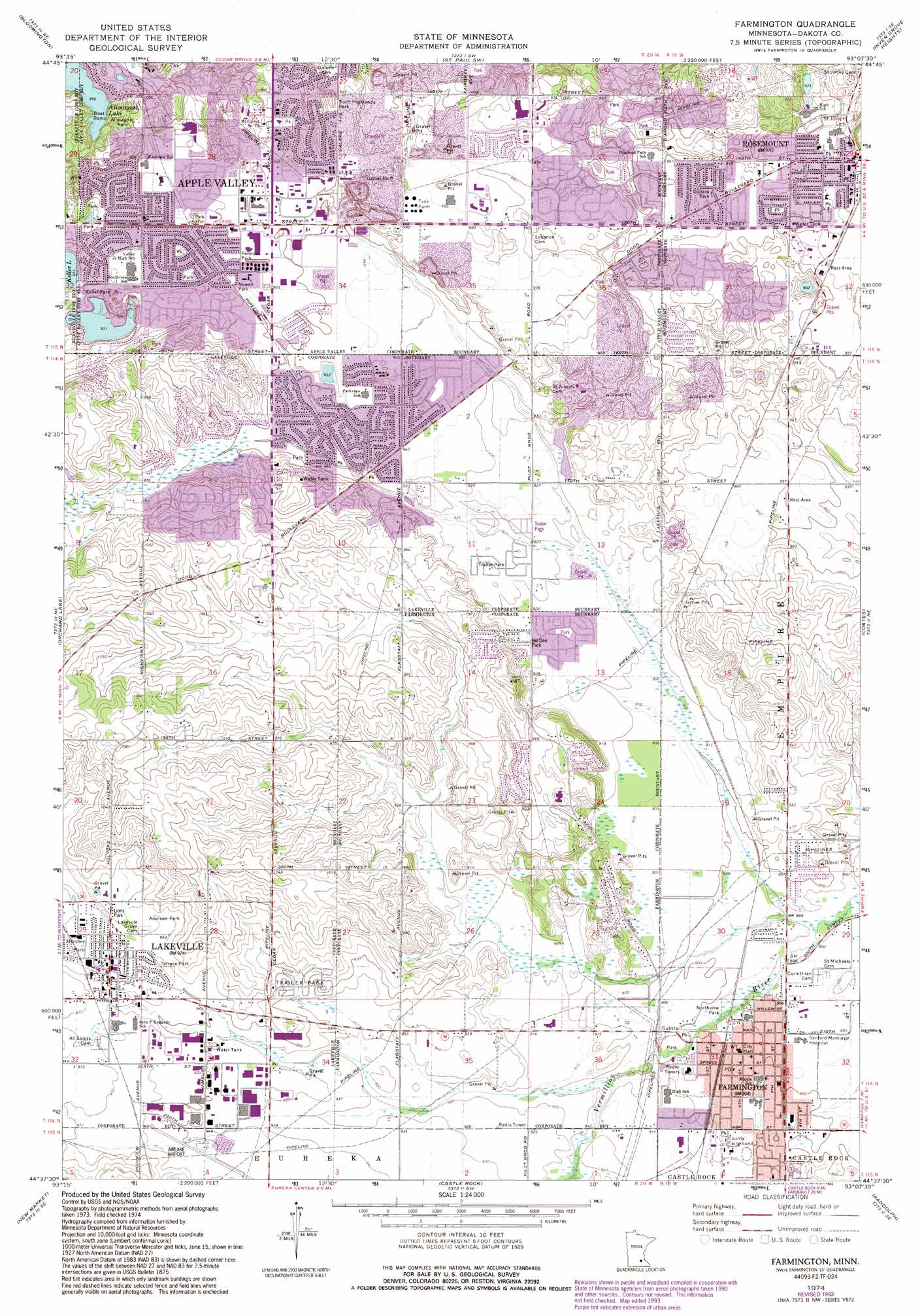
Farmington Topo Map Minnesota
To zoom in, hover over the map of Farmington
USGS Topo Quad 44093f2 - 1:24,000 scale
| Topo Map Name: | Farmington |
| USGS Topo Quad ID: | 44093f2 |
| Print Size: | ca. 21 1/4" wide x 27" high |
| Southeast Coordinates: | 44.625° N latitude / 93.125° W longitude |
| Map Center Coordinates: | 44.6875° N latitude / 93.1875° W longitude |
| U.S. State: | MN |
| Filename: | o44093f2.jpg |
| Download Map JPG Image: | Farmington topo map 1:24,000 scale |
| Map Type: | Topographic |
| Topo Series: | 7.5´ |
| Map Scale: | 1:24,000 |
| Source of Map Images: | United States Geological Survey (USGS) |
| Alternate Map Versions: |
Farmington MN 1974, updated 1976 Download PDF Buy paper map Farmington MN 1974, updated 1993 Download PDF Buy paper map Farmington MN 2010 Download PDF Buy paper map Farmington MN 2013 Download PDF Buy paper map Farmington MN 2016 Download PDF Buy paper map |
1:24,000 Topo Quads surrounding Farmington
Hopkins |
Minneapolis South |
Saint Paul West |
Saint Paul East |
Lake Elmo |
Eden Prairie |
Bloomington |
Saint Paul Sw |
Inver Grove Heights |
Saint Paul Park |
Prior Lake |
Orchard Lake |
Farmington |
Coates |
Vermillion |
Veseli |
New Market |
Castle Rock |
Randolph |
Cannon Falls |
Lonsdale |
Little Chicago |
Northfield |
Dennison |
Sogn |
> Back to 44093e1 at 1:100,000 scale
> Back to 44092a1 at 1:250,000 scale
> Back to U.S. Topo Maps home
Farmington topo map: Gazetteer
Farmington: Airports
Airlake Airport elevation 291m 954′Farmington: Lakes
Alimagnet Lake elevation 291m 954′Lac Lavon Lake elevation 285m 935′
Farmington: Parks
Alimagnet Park elevation 293m 961′Apple Grove Park elevation 293m 961′
Apple Ponds Park elevation 290m 951′
Apple Valley East Park elevation 293m 961′
Aronson Park elevation 296m 971′
Bunker Hill Park elevation 289m 948′
Camfield Park elevation 293m 961′
Carroll's Woods Park elevation 292m 958′
Carrollwood Park elevation 298m 977′
Cedar Highlands Park elevation 302m 990′
Cedar Isle Park elevation 304m 997′
Cherryview Park elevation 315m 1033′
Cherryview Pond Park elevation 310m 1017′
Chippendale Park elevation 293m 961′
Claret Park elevation 288m 944′
Connemara Park elevation 290m 951′
Daisy Knoll Park elevation 307m 1007′
Dakota Estates Park elevation 279m 915′
Dallara Park elevation 293m 961′
Delaney Park elevation 290m 951′
Diamond Path Park elevation 290m 951′
Dodd Trail Park elevation 282m 925′
Duchess Park elevation 293m 961′
Fair Hills Park elevation 294m 964′
Foxborough Park elevation 288m 944′
Fred J Largen Park elevation 294m 964′
Galaxie Park elevation 290m 951′
Green Ridge Park elevation 293m 961′
Greening Park elevation 292m 958′
Hayes Field elevation 296m 971′
Hershey Park elevation 297m 974′
Highview Heights Park elevation 320m 1049′
Hill Dee Park elevation 280m 918′
Jaycee Park elevation 293m 961′
Johnny Lake Ridge Park East elevation 303m 994′
Johnny Lake Ridge Park West elevation 297m 974′
Keller Park elevation 289m 948′
Kidder Park elevation 293m 961′
Lac Lavon Park elevation 293m 961′
Lake Julia Park elevation 278m 912′
Lions Park elevation 295m 967′
Lions Park elevation 294m 964′
Longridge Park elevation 309m 1013′
Meadow View Park elevation 278m 912′
Newell Park elevation 292m 958′
Northview Park elevation 272m 892′
Pennock Park elevation 292m 958′
Pine Knoll Park elevation 283m 928′
Prairie Creek Park elevation 277m 908′
Prairie View Park elevation 275m 902′
Preserve Park elevation 276m 905′
Rambling River Park elevation 274m 898′
Redwood Park elevation 293m 961′
Regatta Park elevation 299m 980′
Schwarz Pond Park elevation 289m 948′
Scott Highlands Park elevation 296m 971′
Tamarack Park elevation 273m 895′
Terrace Park elevation 292m 958′
Tintah Park elevation 296m 971′
Troy Hills Park elevation 291m 954′
Twin Puddles Park elevation 293m 961′
Valley Lake Park elevation 287m 941′
Valley Middle Park elevation 293m 961′
Westview Park elevation 277m 908′
Westview Park elevation 296m 971′
Winds Park elevation 287m 941′
Woodbury Park elevation 293m 961′
Farmington: Populated Places
Apple Valley elevation 291m 954′Farmington elevation 275m 902′
Lakeville elevation 296m 971′
Rosemount elevation 294m 964′
Farmington digital topo map on disk
Buy this Farmington topo map showing relief, roads, GPS coordinates and other geographical features, as a high-resolution digital map file on DVD: