Redwood Falls Topo Map Minnesota
To zoom in, hover over the map of Redwood Falls
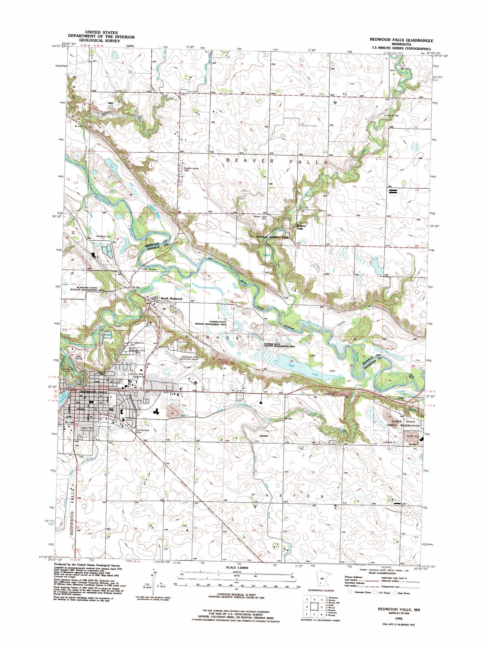
USGS Topo Quad 44095e1 - 1:24,000 scale
| Topo Map Name: | Redwood Falls |
| USGS Topo Quad ID: | 44095e1 |
| Print Size: | ca. 21 1/4" wide x 27" high |
| Southeast Coordinates: | 44.5° N latitude / 95° W longitude |
| Map Center Coordinates: | 44.5625° N latitude / 95.0625° W longitude |
| U.S. State: | MN |
| Filename: | o44095e1.jpg |
| Download Map JPG Image: | Redwood Falls topo map 1:24,000 scale |
| Map Type: | Topographic |
| Topo Series: | 7.5´ |
| Map Scale: | 1:24,000 |
| Source of Map Images: | United States Geological Survey (USGS) |
| Alternate Map Versions: |
Redwood Falls MN 1982, updated 1983 Download PDF Buy paper map Redwood Falls MN 1982, updated 1986 Download PDF Buy paper map Redwood Falls MN 1992, updated 1995 Download PDF Buy paper map Redwood Falls MN 2010 Download PDF Buy paper map Redwood Falls MN 2013 Download PDF Buy paper map Redwood Falls MN 2016 Download PDF Buy paper map |
1:24,000 Topo Quads surrounding Redwood Falls
Sacred Heart |
Renville |
Danube |
Olivia |
Olivia Se |
Iverson Lake |
Vicksburg |
Bechyn |
Morton Nw |
Morton Ne |
Belview |
Delhi |
Redwood Falls |
Morton |
Morton Se |
Wabasso |
Rowena |
Clements |
Morgan |
Morgan Ne |
Wabasso Se |
Wanda |
Clements Se |
Boise Lake |
Evan |
> Back to 44095e1 at 1:100,000 scale
> Back to 44094a1 at 1:250,000 scale
> Back to U.S. Topo Maps home
Redwood Falls topo map: Gazetteer
Redwood Falls: Airports
Redwood Falls Municipal Airport elevation 311m 1020′Redwood Falls: Bridges
Ramsey Park Swayback Bridge elevation 267m 875′Redwood Falls: Canals
County Ditch Number Fiftytwo elevation 311m 1020′Redwood Falls: Dams
Redwood River Dam elevation 302m 990′Redwood Falls: Lakes
Davis Lake elevation 256m 839′Lake Redwood elevation 302m 990′
Sulphur Lake elevation 250m 820′
Tiger Lake elevation 252m 826′
Redwood Falls: Parks
Geology of the Minnesota River Valley Historical Marker elevation 261m 856′Geology of the Redwood Falls Region Historical Marker elevation 274m 898′
Honner State Wildlife Management Area elevation 258m 846′
Klabunde State Wildlife Management Area elevation 310m 1017′
Legion Park elevation 311m 1020′
Memorial Park elevation 311m 1020′
Normandale Park elevation 311m 1020′
Ramsey Park elevation 300m 984′
Redwood Falls Retaining Wall Park elevation 307m 1007′
Redwood River Wayside Park elevation 288m 944′
Renville County Park elevation 284m 931′
Schwandt State Monument elevation 306m 1003′
Tyson Park elevation 316m 1036′
Wowinape or Thomas Wakeman (1846-1886) Historical Marker elevation 309m 1013′
Redwood Falls: Populated Places
Beaver Falls elevation 281m 921′North Redwood elevation 259m 849′
Redwood Falls elevation 317m 1040′
Redwood Falls: Post Offices
Beaver Falls Post Office (historical) elevation 281m 921′North Redwood Post Office (historical) elevation 258m 846′
Redwood Falls Post Office elevation 315m 1033′
Redwood Falls: Reservoirs
Redwood Lake elevation 302m 990′Redwood Falls: Streams
Beaver Creek elevation 251m 823′Camp Pope Creek elevation 255m 836′
Crow Creek elevation 250m 820′
Redwood River elevation 253m 830′
Smith Creek elevation 252m 826′
Redwood Falls digital topo map on disk
Buy this Redwood Falls topo map showing relief, roads, GPS coordinates and other geographical features, as a high-resolution digital map file on DVD: