Dawson Nw Topo Map Minnesota
To zoom in, hover over the map of Dawson Nw
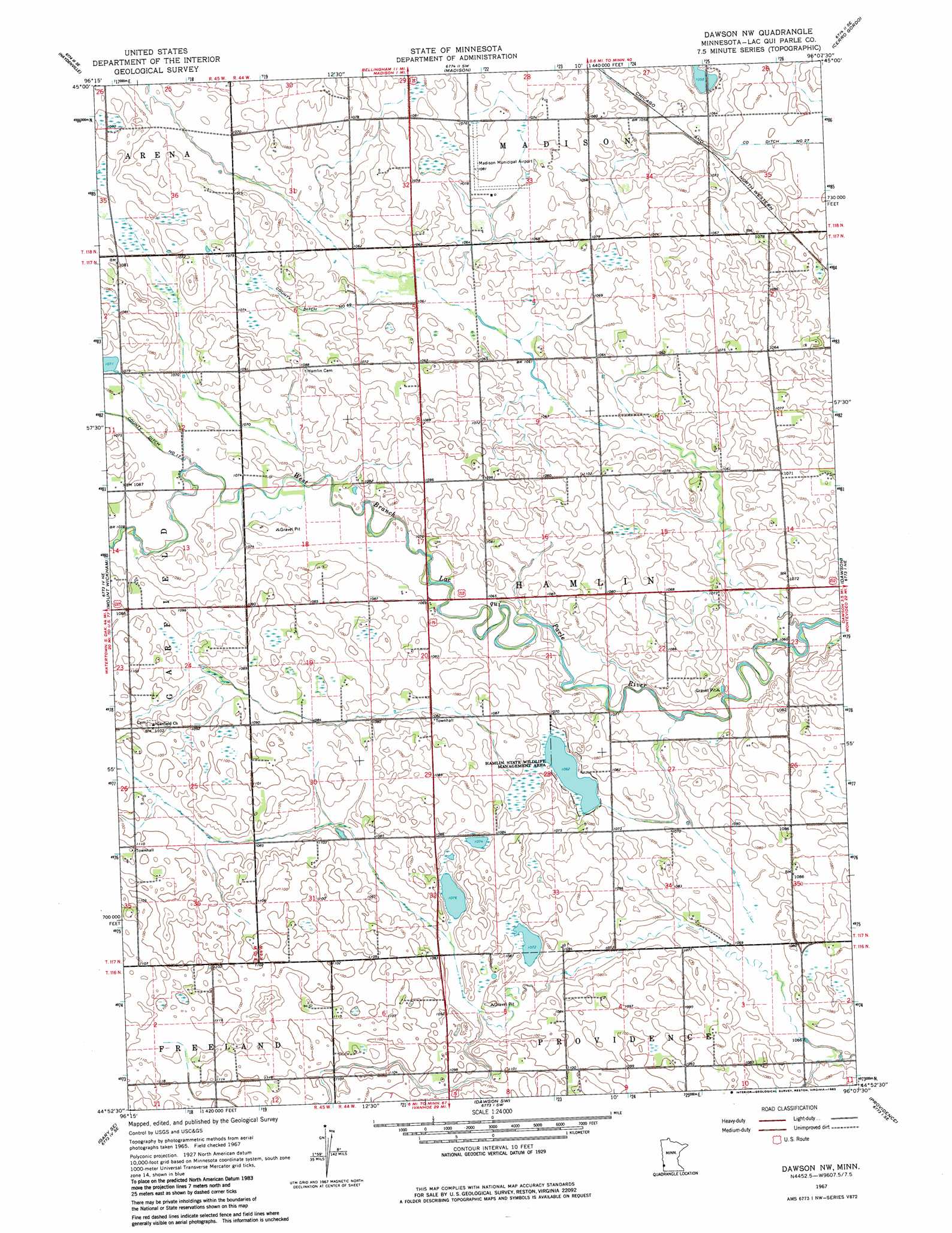
USGS Topo Quad 44096h2 - 1:24,000 scale
| Topo Map Name: | Dawson Nw |
| USGS Topo Quad ID: | 44096h2 |
| Print Size: | ca. 21 1/4" wide x 27" high |
| Southeast Coordinates: | 44.875° N latitude / 96.125° W longitude |
| Map Center Coordinates: | 44.9375° N latitude / 96.1875° W longitude |
| U.S. State: | MN |
| Filename: | o44096h2.jpg |
| Download Map JPG Image: | Dawson Nw topo map 1:24,000 scale |
| Map Type: | Topographic |
| Topo Series: | 7.5´ |
| Map Scale: | 1:24,000 |
| Source of Map Images: | United States Geological Survey (USGS) |
| Alternate Map Versions: |
Dawson NW MN 1967, updated 1968 Download PDF Buy paper map Dawson NW MN 1967, updated 1982 Download PDF Buy paper map Dawson NW MN 2010 Download PDF Buy paper map Dawson NW MN 2013 Download PDF Buy paper map Dawson NW MN 2016 Download PDF Buy paper map |
1:24,000 Topo Quads surrounding Dawson Nw
Rosen |
Bellingham |
Correll |
Appleton |
Milan Nw |
Marietta |
Haydenville |
Madison |
Cerro Gordo |
Milan |
Gary Nw |
Mount Wickham |
Dawson Nw |
Dawson |
Tenmile Lake |
Gary |
Gary Se |
Dawson Sw |
Providence |
Boyd |
Canby Nw |
Canby |
Porter |
Saint Leo |
Minneota Nw |
> Back to 44096e1 at 1:100,000 scale
> Back to 44096a1 at 1:250,000 scale
> Back to U.S. Topo Maps home
Dawson Nw topo map: Gazetteer
Dawson Nw: Airports
Madison-Lac Qui Parle County Airport elevation 326m 1069′Dawson Nw: Canals
County Ditch Number Eightyfive elevation 333m 1092′County Ditch Number Sixtynine elevation 326m 1069′
Dawson Nw: Parks
Hamlin State Wildlife Management Area elevation 324m 1062′Dawson Nw digital topo map on disk
Buy this Dawson Nw topo map showing relief, roads, GPS coordinates and other geographical features, as a high-resolution digital map file on DVD:
Eastern North Dakota & Eastern South Dakota
Buy digital topo maps: Eastern North Dakota & Eastern South Dakota