Ames Topo Map South Dakota
To zoom in, hover over the map of Ames
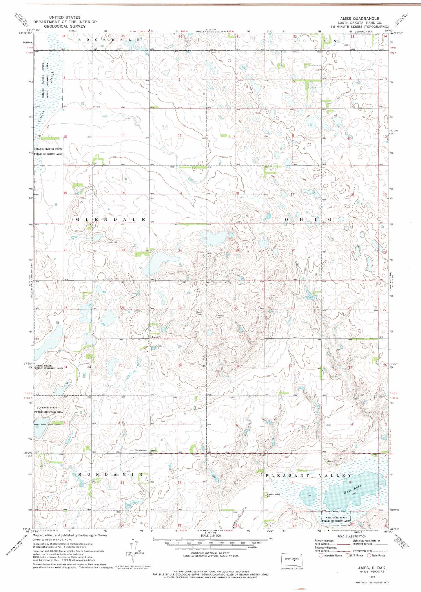
USGS Topo Quad 44099c1 - 1:24,000 scale
| Topo Map Name: | Ames |
| USGS Topo Quad ID: | 44099c1 |
| Print Size: | ca. 21 1/4" wide x 27" high |
| Southeast Coordinates: | 44.25° N latitude / 99° W longitude |
| Map Center Coordinates: | 44.3125° N latitude / 99.0625° W longitude |
| U.S. State: | SD |
| Filename: | o44099c1.jpg |
| Download Map JPG Image: | Ames topo map 1:24,000 scale |
| Map Type: | Topographic |
| Topo Series: | 7.5´ |
| Map Scale: | 1:24,000 |
| Source of Map Images: | United States Geological Survey (USGS) |
| Alternate Map Versions: |
Ames SD 1973, updated 1976 Download PDF Buy paper map Ames SD 2012 Download PDF Buy paper map Ames SD 2015 Download PDF Buy paper map |
1:24,000 Topo Quads surrounding Ames
Highmore Se |
Ree Heights |
Ree Heights Se |
Miller |
Miller Se |
Macs Corner Ne |
Miller Dale Colony Nw |
Miller Dale Colony |
Vayland Nw |
Vayland |
Macs Corner Se |
Miller Dale Colony Sw |
Ames |
Vayland Sw |
Vayland Se |
Big Bend Dam Ne |
Big Bend Dam 4 Nw |
Big Bend Dam 4 Ne |
Mittelstedt Slough |
Cottonwood Lake |
Big Bend Dam Se |
Big Bend Dam 4 Sw |
Big Bend Dam 4 Se |
Gannvalley |
Gannvalley Se |
> Back to 44099a1 at 1:100,000 scale
> Back to 44098a1 at 1:250,000 scale
> Back to U.S. Topo Maps home
Ames topo map: Gazetteer
Ames: Dams
A Heezen Dam elevation 564m 1850′M Fisher Dam elevation 588m 1929′
Ames: Lakes
Wall Lake elevation 535m 1755′Ames: Parks
Wall Lake State Public Shooting Area elevation 536m 1758′Ames: Populated Places
Ames elevation 574m 1883′Ames: Swamps
Collins Slough elevation 581m 1906′Ames digital topo map on disk
Buy this Ames topo map showing relief, roads, GPS coordinates and other geographical features, as a high-resolution digital map file on DVD:
Eastern North Dakota & Eastern South Dakota
Buy digital topo maps: Eastern North Dakota & Eastern South Dakota