Artichoke Butte Sw Topo Map South Dakota
To zoom in, hover over the map of Artichoke Butte Sw
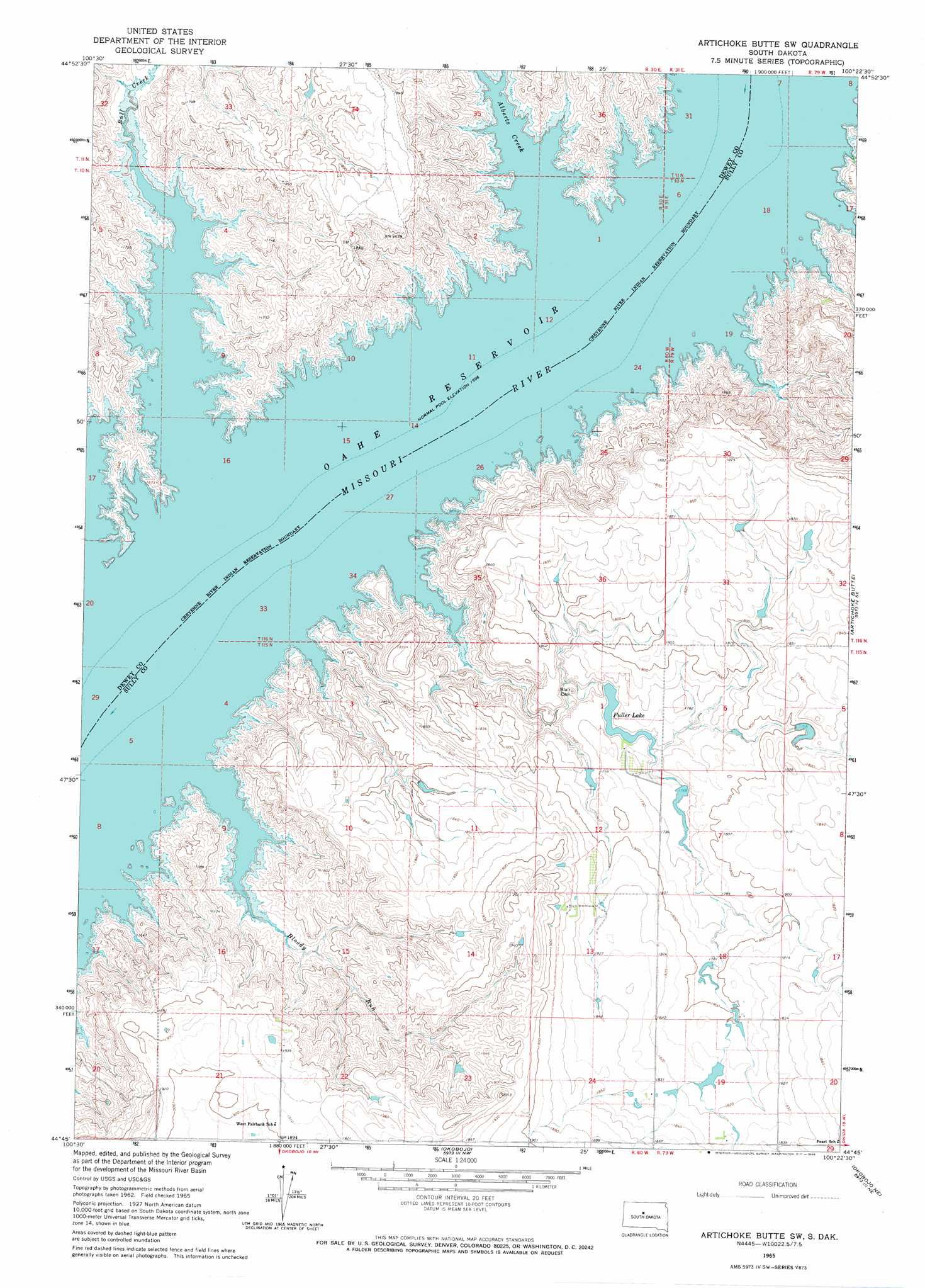
USGS Topo Quad 44100g4 - 1:24,000 scale
| Topo Map Name: | Artichoke Butte Sw |
| USGS Topo Quad ID: | 44100g4 |
| Print Size: | ca. 21 1/4" wide x 27" high |
| Southeast Coordinates: | 44.75° N latitude / 100.375° W longitude |
| Map Center Coordinates: | 44.8125° N latitude / 100.4375° W longitude |
| U.S. State: | SD |
| Filename: | o44100g4.jpg |
| Download Map JPG Image: | Artichoke Butte Sw topo map 1:24,000 scale |
| Map Type: | Topographic |
| Topo Series: | 7.5´ |
| Map Scale: | 1:24,000 |
| Source of Map Images: | United States Geological Survey (USGS) |
| Alternate Map Versions: |
Artichoke Butte SW SD 1965, updated 1966 Download PDF Buy paper map Artichoke Butte SW SD 2012 Download PDF Buy paper map Artichoke Butte SW SD 2015 Download PDF Buy paper map |
1:24,000 Topo Quads surrounding Artichoke Butte Sw
La Plant Sw |
Stove Creek |
Patch Skin Buttes Sw |
Patch Skin Buttes Se |
Lake Hurley |
No Heart Creek |
No Heart Creek Ne |
Artichoke Butte Nw |
Artichoke Butte Ne |
Agar Nw |
No Heart Creek Sw |
No Heart Creek Se |
Artichoke Butte Sw |
Artichoke Butte |
Agar Sw |
Iron Post Buttes |
Mail Shack Creek |
Okobojo |
Okobojo Ne |
Sully Lake |
Iron Post Buttes Sw |
Iron Post Buttes Se |
Okobojo Sw |
Okobojo Se |
Onida Sw |
> Back to 44100e1 at 1:100,000 scale
> Back to 44100a1 at 1:250,000 scale
> Back to U.S. Topo Maps home
Artichoke Butte Sw topo map: Gazetteer
Artichoke Butte Sw: Dams
K Darland Dam elevation 542m 1778′Artichoke Butte Sw: Islands
Plum Island (historical) elevation 490m 1607′Artichoke Butte Sw: Reservoirs
Fuller Lake elevation 534m 1751′Artichoke Butte Sw: Streams
Alberts Creek elevation 490m 1607′Bloody Run elevation 490m 1607′
Bull Creek elevation 490m 1607′
Artichoke Butte Sw: Valleys
Stony Gulch (historical) elevation 490m 1607′Artichoke Butte Sw digital topo map on disk
Buy this Artichoke Butte Sw topo map showing relief, roads, GPS coordinates and other geographical features, as a high-resolution digital map file on DVD:
Eastern North Dakota & Eastern South Dakota
Buy digital topo maps: Eastern North Dakota & Eastern South Dakota