Rapid City East Topo Map South Dakota
To zoom in, hover over the map of Rapid City East
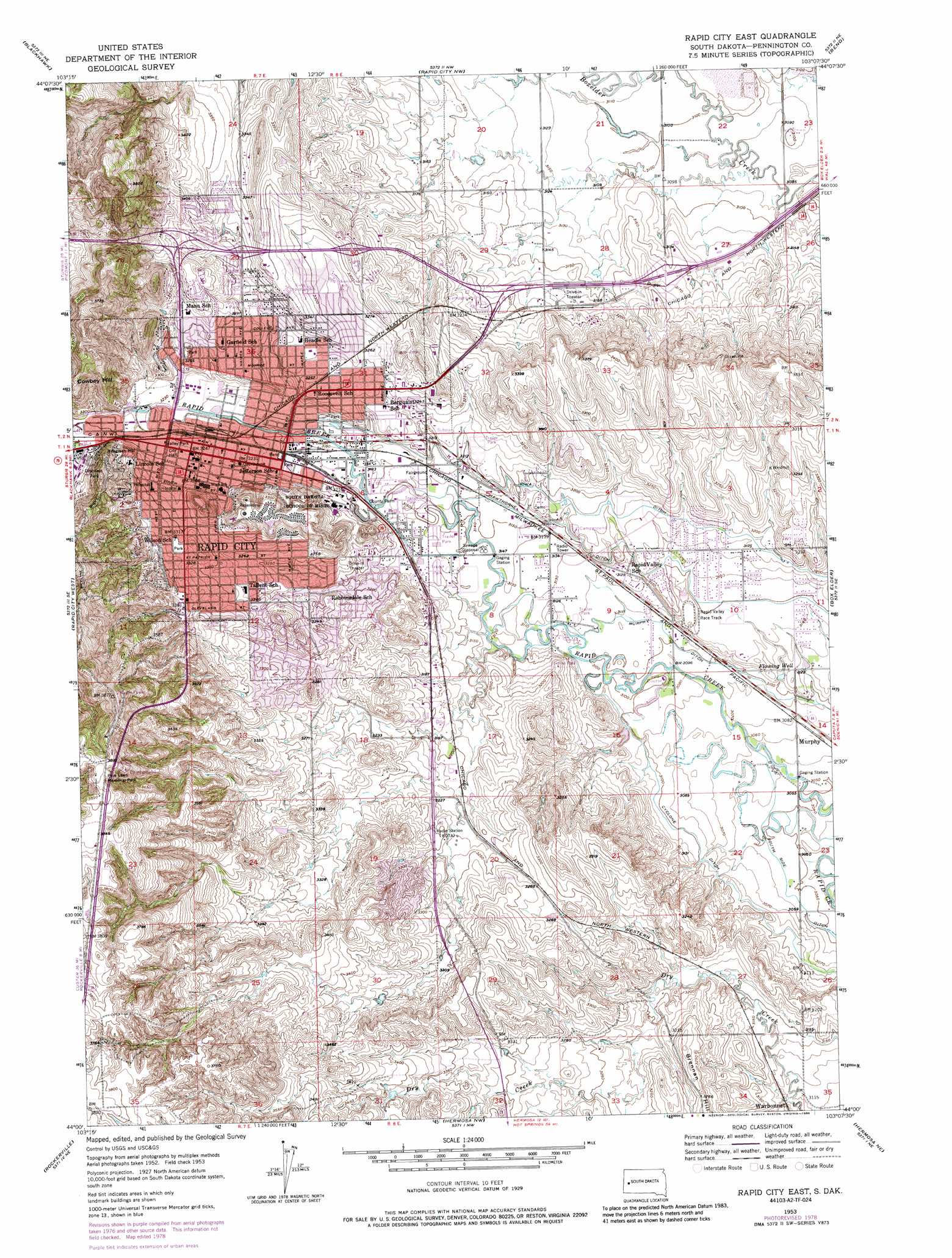
USGS Topo Quad 44103a2 - 1:24,000 scale
| Topo Map Name: | Rapid City East |
| USGS Topo Quad ID: | 44103a2 |
| Print Size: | ca. 21 1/4" wide x 27" high |
| Southeast Coordinates: | 44° N latitude / 103.125° W longitude |
| Map Center Coordinates: | 44.0625° N latitude / 103.1875° W longitude |
| U.S. State: | SD |
| Filename: | o44103a2.jpg |
| Download Map JPG Image: | Rapid City East topo map 1:24,000 scale |
| Map Type: | Topographic |
| Topo Series: | 7.5´ |
| Map Scale: | 1:24,000 |
| Source of Map Images: | United States Geological Survey (USGS) |
| Alternate Map Versions: |
Rapid City East SD 1953, updated 1955 Download PDF Buy paper map Rapid City East SD 1953, updated 1968 Download PDF Buy paper map Rapid City East SD 1953, updated 1972 Download PDF Buy paper map Rapid City East SD 1953, updated 1978 Download PDF Buy paper map Rapid City East SD 1953, updated 1986 Download PDF Buy paper map Rapid City East SD 1953, updated 1986 Download PDF Buy paper map Rapid City East SD 1953, updated 1986 Download PDF Buy paper map Rapid City East SD 2012 Download PDF Buy paper map Rapid City East SD 2015 Download PDF Buy paper map |
1:24,000 Topo Quads surrounding Rapid City East
Tilford |
Fort Meade Se |
Rapid City 1 Sw |
Rapid City 1 Se |
Hereford Sw |
Piedmont |
Blackhawk |
Rapid City Nw |
Bend |
New Underwood Nw |
Pactola Dam |
Rapid City West |
Rapid City East |
Box Elder |
New Underwood Sw |
Mount Rushmore |
Rockerville |
Hermosa Nw |
Hermosa Ne |
Caputa |
Iron Mountain |
Hayward |
Hermosa |
Hermosa Se |
Caputa Sw |
> Back to 44103a1 at 1:100,000 scale
> Back to 44102a1 at 1:250,000 scale
> Back to U.S. Topo Maps home
Rapid City East topo map: Gazetteer
Rapid City East: Canals
Cyclone Ditch elevation 944m 3097′Hawthorne Ditch elevation 962m 3156′
Iowa Ditch elevation 972m 3188′
Rapid City East: Parks
College Park elevation 1011m 3316′Dinosaur Park elevation 1073m 3520′
Halley Park elevation 988m 3241′
Robbinsdale Park elevation 966m 3169′
Roosevelt Park elevation 978m 3208′
Wilson Park elevation 1007m 3303′
Rapid City East: Populated Places
Lakota Homes elevation 1031m 3382′Murphy elevation 936m 3070′
Rapid City elevation 988m 3241′
Rapid Valley elevation 962m 3156′
Sioux Village elevation 1033m 3389′
Twilight Hills Addition elevation 1005m 3297′
Rapid City East: Post Offices
Rapid City Post Office elevation 974m 3195′Rapid City East: Summits
Cowboy Hill elevation 1116m 3661′Hangman Hill elevation 1057m 3467′
Rapid City East digital topo map on disk
Buy this Rapid City East topo map showing relief, roads, GPS coordinates and other geographical features, as a high-resolution digital map file on DVD:
Eastern Wyoming & Western South Dakota
Buy digital topo maps: Eastern Wyoming & Western South Dakota