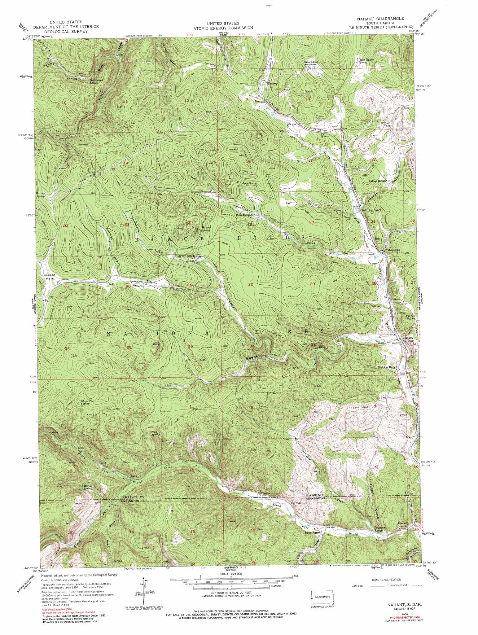
Nahant Topo Map South Dakota
To zoom in, hover over the map of Nahant
USGS Topo Quad 44103b7 - 1:24,000 scale
| Topo Map Name: | Nahant |
| USGS Topo Quad ID: | 44103b7 |
| Print Size: | ca. 21 1/4" wide x 27" high |
| Southeast Coordinates: | 44.125° N latitude / 103.75° W longitude |
| Map Center Coordinates: | 44.1875° N latitude / 103.8125° W longitude |
| U.S. State: | SD |
| Filename: | o44103b7.jpg |
| Download Map JPG Image: | Nahant topo map 1:24,000 scale |
| Map Type: | Topographic |
| Topo Series: | 7.5´ |
| Map Scale: | 1:24,000 |
| Source of Map Images: | United States Geological Survey (USGS) |
| Alternate Map Versions: |
Nahant SD 1956, updated 1958 Download PDF Buy paper map Nahant SD 1956, updated 1963 Download PDF Buy paper map Nahant SD 1956, updated 1978 Download PDF Buy paper map Nahant SD 1956, updated 1989 Download PDF Buy paper map Nahant SD 2012 Download PDF Buy paper map Nahant SD 2015 Download PDF Buy paper map |
| FStopo: | US Forest Service topo Nahant is available: Download FStopo PDF Download FStopo TIF |
1:24,000 Topo Quads surrounding Nahant
Tinton |
Maurice |
Spearfish |
Deadwood North |
Sturgis |
Old Baldy Mountain |
Savoy |
Lead |
Deadwood South |
Deadman Mountain |
Buckhorn |
Crooks Tower |
Nahant |
Minnesota Ridge |
Nemo |
Parmlee Canyon |
Crows Nest Peak |
Deerfield |
Rochford |
Silver City |
Moon |
Preacher Spring |
Ditch Creek |
Medicine Mountain |
Hill City |
> Back to 44103a1 at 1:100,000 scale
> Back to 44102a1 at 1:250,000 scale
> Back to U.S. Topo Maps home
Nahant topo map: Gazetteer
Nahant: Flats
Besant Park elevation 1957m 6420′Nahant: Populated Places
Dumont elevation 1876m 6154′Florence (historical) elevation 1746m 5728′
Nahant elevation 1732m 5682′
Nahant: Springs
Beaver Spring elevation 1861m 6105′Beaver Spring elevation 1853m 6079′
Black Fox Spring elevation 1994m 6541′
Buck Spring elevation 1840m 6036′
Graveyard Spring elevation 1841m 6040′
Harvey Spring elevation 1964m 6443′
Harvey Spring elevation 1963m 6440′
Irey Spring elevation 1887m 6190′
Rickgauer Spring elevation 1945m 6381′
Seep Spring elevation 1894m 6213′
Nahant: Streams
Buskala Creek elevation 1761m 5777′Hop Creek elevation 1681m 5515′
Rhoads Fork elevation 1784m 5853′
Tillson Creek elevation 1726m 5662′
Nahant: Valleys
Bee Draw elevation 1852m 6076′Billings Draw elevation 1931m 6335′
Cave Draw elevation 1807m 5928′
Dump Draw elevation 1672m 5485′
Gudat Gulch elevation 1783m 5849′
Hallorans Draw elevation 1882m 6174′
Hollens Draw elevation 1887m 6190′
Long Draw elevation 1782m 5846′
Swede Gulch elevation 1738m 5702′
Telegraph Gulch elevation 1682m 5518′
Nahant digital topo map on disk
Buy this Nahant topo map showing relief, roads, GPS coordinates and other geographical features, as a high-resolution digital map file on DVD:
Eastern Wyoming & Western South Dakota
Buy digital topo maps: Eastern Wyoming & Western South Dakota