Arpan Topo Map South Dakota
To zoom in, hover over the map of Arpan
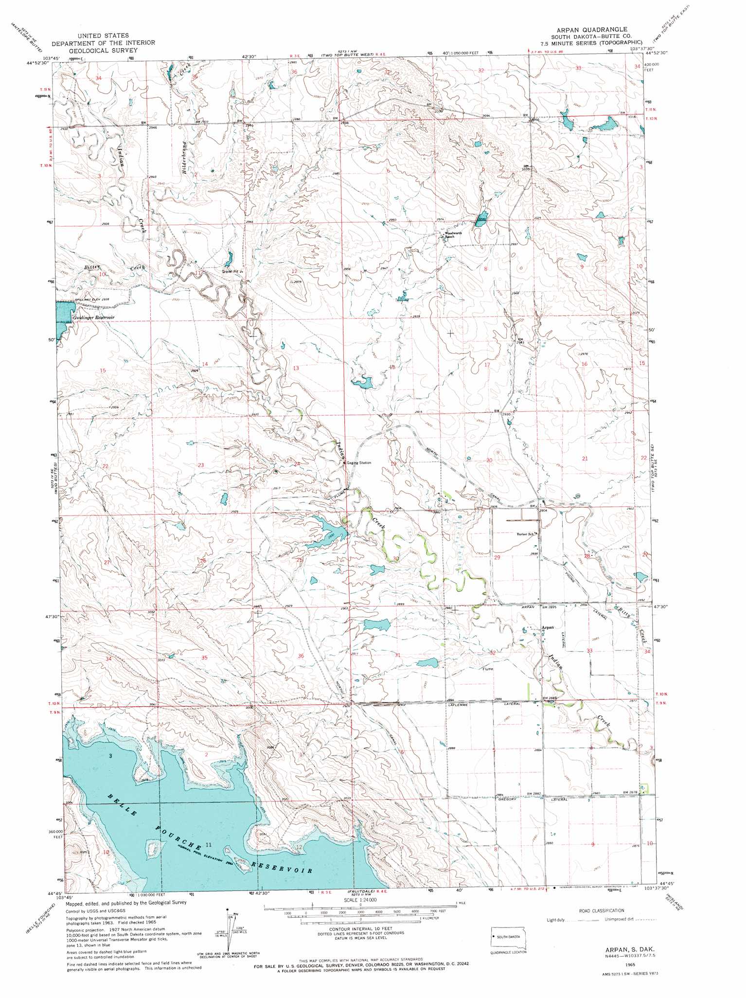
USGS Topo Quad 44103g6 - 1:24,000 scale
| Topo Map Name: | Arpan |
| USGS Topo Quad ID: | 44103g6 |
| Print Size: | ca. 21 1/4" wide x 27" high |
| Southeast Coordinates: | 44.75° N latitude / 103.625° W longitude |
| Map Center Coordinates: | 44.8125° N latitude / 103.6875° W longitude |
| U.S. State: | SD |
| Filename: | o44103g6.jpg |
| Download Map JPG Image: | Arpan topo map 1:24,000 scale |
| Map Type: | Topographic |
| Topo Series: | 7.5´ |
| Map Scale: | 1:24,000 |
| Source of Map Images: | United States Geological Survey (USGS) |
| Alternate Map Versions: |
Arpan SD 1965, updated 1967 Download PDF Buy paper map Arpan SD 2012 Download PDF Buy paper map Arpan SD 2015 Download PDF Buy paper map |
1:24,000 Topo Quads surrounding Arpan
Greasewood Draw |
Battle Creek Butte |
Antelope Creek West |
Antelope Creek East |
Haystack Butte |
Mud Buttes Nw |
Antelope Butte |
Two Top Butte West |
Two Top Butte East |
Castle Rock |
Bull Creek Butte |
Mud Buttes |
Arpan |
Two Top Butte Se |
Newell Lake |
Sourdough Flats |
Belle Fourche |
Fruitdale |
Nisland |
Newell |
Chicken Creek |
Jolly |
Saint Onge |
Saint Onge Se |
Vale |
> Back to 44103e1 at 1:100,000 scale
> Back to 44102a1 at 1:250,000 scale
> Back to U.S. Topo Maps home
Arpan topo map: Gazetteer
Arpan: Canals
Arpan Lateral elevation 881m 2890′Gregory Lateral elevation 876m 2874′
Laflemme Lateral elevation 878m 2880′
Young Lateral elevation 878m 2880′
Arpan: Dams
Guidinger Dam elevation 896m 2939′R L Cundy Dam Number 1 elevation 908m 2979′
Royal McKnight Dam Number 1 elevation 897m 2942′
Royal McKnight Dam Number 2 elevation 882m 2893′
Arpan: Populated Places
Arpan elevation 881m 2890′Arpan: Reservoirs
Guidinger Reservoir elevation 896m 2939′Arpan: Streams
Bitter Creek elevation 884m 2900′Hilderbrand Creek elevation 891m 2923′
Arpan digital topo map on disk
Buy this Arpan topo map showing relief, roads, GPS coordinates and other geographical features, as a high-resolution digital map file on DVD:
Eastern Wyoming & Western South Dakota
Buy digital topo maps: Eastern Wyoming & Western South Dakota