Sundance West Topo Map Wyoming
To zoom in, hover over the map of Sundance West
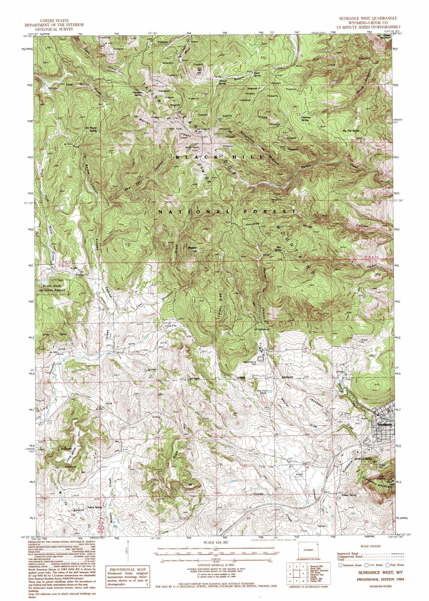
USGS Topo Quad 44104d4 - 1:24,000 scale
| Topo Map Name: | Sundance West |
| USGS Topo Quad ID: | 44104d4 |
| Print Size: | ca. 21 1/4" wide x 27" high |
| Southeast Coordinates: | 44.375° N latitude / 104.375° W longitude |
| Map Center Coordinates: | 44.4375° N latitude / 104.4375° W longitude |
| U.S. State: | WY |
| Filename: | o44104d4.jpg |
| Download Map JPG Image: | Sundance West topo map 1:24,000 scale |
| Map Type: | Topographic |
| Topo Series: | 7.5´ |
| Map Scale: | 1:24,000 |
| Source of Map Images: | United States Geological Survey (USGS) |
| Alternate Map Versions: |
Sundance West WY 1984, updated 1985 Download PDF Buy paper map Sundance West WY 1984, updated 1995 Download PDF Buy paper map Sundance West WY 2012 Download PDF Buy paper map Sundance West WY 2015 Download PDF Buy paper map |
| FStopo: | US Forest Service topo Sundance West is available: Download FStopo PDF Download FStopo TIF |
1:24,000 Topo Quads surrounding Sundance West
Moore Hill |
Hulett |
Alva |
The Notch |
Aladdin |
Devils Tower |
Sherrard Hill |
Black Hills |
Sugarloaf Mountain |
Schoolmarm Butte |
Wonder View |
The Rocks |
Sundance West |
Sundance East |
Red Canyon Creek |
Iron Mountain |
Linden |
Pfeiffer Hill |
Duling Hill |
Moskee |
Thornton |
Arrowhead Reservoir |
Sheldon Creek |
Inyan Kara Mountain |
Dry Draw |
> Back to 44104a1 at 1:100,000 scale
> Back to 44104a1 at 1:250,000 scale
> Back to U.S. Topo Maps home
Sundance West topo map: Gazetteer
Sundance West: Airports
Schloredt Airport elevation 1482m 4862′Sundance West: Dams
Gose Dam elevation 1735m 5692′Sundance West: Mines
Albert Mann Mine elevation 1635m 5364′American Colloid Pits Mine elevation 1663m 5456′
Bear Lodge Mining District Mine elevation 1766m 5793′
Belsher Mine elevation 1587m 5206′
Bock Mine elevation 1922m 6305′
Bolton Mine elevation 1595m 5232′
Climax Ten Mine elevation 1827m 5994′
Copper Prince Mine elevation 1712m 5616′
Homes Fire Lode Forty-three elevation 1891m 6204′
Hutchins Consolidated Gold Mining Mine elevation 1934m 6345′
Inum One Claim elevation 1948m 6391′
Jim Wayne Canyon Mine elevation 1743m 5718′
Lytle Creek Prospect Mine elevation 1923m 6309′
Lytle Five Claim elevation 1993m 6538′
Lytle Three Claim elevation 1948m 6391′
Peterson Deposits Mine elevation 1769m 5803′
Potluck One Mine elevation 1813m 5948′
Potluck Two Mine elevation 1813m 5948′
Royal Purple Number One and Number Two Mine elevation 1798m 5898′
Royal Purple Number One and Number Two Mine elevation 1775m 5823′
Summit Materials Quarry Mine elevation 1599m 5246′
Sunrise Lode Mine elevation 1779m 5836′
Victory Lode Mine elevation 1875m 6151′
Warren Peaks Mine elevation 1833m 6013′
Sundance West: Populated Places
Sundance elevation 1444m 4737′Vista West Trailer Park elevation 1569m 5147′
Sundance West: Reservoirs
Gose Reservoir elevation 1735m 5692′Sundance West: Ridges
Houston Ridge elevation 1863m 6112′Smith Ridge elevation 1938m 6358′
Sundance West: Springs
Allread Spring elevation 1842m 6043′Big Flat Spring elevation 1726m 5662′
Box Spring elevation 1841m 6040′
Cole Spring elevation 1840m 6036′
Davis Spring elevation 1809m 5935′
Huchins Spring elevation 1869m 6131′
Jacobson Spring elevation 1491m 4891′
Jim Wayne Spring elevation 1790m 5872′
Kaiser Spring elevation 1502m 4927′
Loafman Springs elevation 1512m 4960′
Peterson Spring elevation 1813m 5948′
Talbot Spring elevation 1489m 4885′
Sundance West: Streams
Chassell Creek elevation 1472m 4829′Hoyer Creek elevation 1482m 4862′
Lost Houston Creek elevation 1566m 5137′
North Fork Sundance Creek elevation 1449m 4753′
Richardson Creek elevation 1703m 5587′
Sundance West: Summits
Bull Hill elevation 1948m 6391′Coal Mine Hill elevation 1638m 5374′
Ragged Top elevation 1909m 6263′
Rupe Hill elevation 1636m 5367′
Sundance Mountain elevation 1771m 5810′
Warren Peaks elevation 1961m 6433′
Sundance West: Valleys
Bear Den Canyon elevation 1676m 5498′Carson Draw elevation 1615m 5298′
Cole Canyon elevation 1541m 5055′
Jacobson Draw elevation 1508m 4947′
Jim Wayne Canyon elevation 1675m 5495′
Krusee Canyon elevation 1569m 5147′
Reuter Canyon elevation 1943m 6374′
Reuter Draw elevation 1463m 4799′
Tent Canyon elevation 1535m 5036′
Sundance West digital topo map on disk
Buy this Sundance West topo map showing relief, roads, GPS coordinates and other geographical features, as a high-resolution digital map file on DVD:
Eastern Wyoming & Western South Dakota
Buy digital topo maps: Eastern Wyoming & Western South Dakota