Wood Canyon Topo Map Wyoming
To zoom in, hover over the map of Wood Canyon
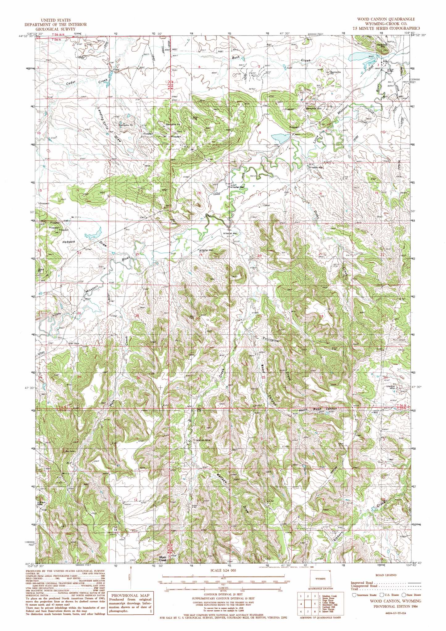
USGS Topo Quad 44104g7 - 1:24,000 scale
| Topo Map Name: | Wood Canyon |
| USGS Topo Quad ID: | 44104g7 |
| Print Size: | ca. 21 1/4" wide x 27" high |
| Southeast Coordinates: | 44.75° N latitude / 104.75° W longitude |
| Map Center Coordinates: | 44.8125° N latitude / 104.8125° W longitude |
| U.S. State: | WY |
| Filename: | o44104g7.jpg |
| Download Map JPG Image: | Wood Canyon topo map 1:24,000 scale |
| Map Type: | Topographic |
| Topo Series: | 7.5´ |
| Map Scale: | 1:24,000 |
| Source of Map Images: | United States Geological Survey (USGS) |
| Alternate Map Versions: |
Wood Canyon WY 1984, updated 1985 Download PDF Buy paper map Wood Canyon WY 2012 Download PDF Buy paper map Wood Canyon WY 2015 Download PDF Buy paper map |
1:24,000 Topo Quads surrounding Wood Canyon
Belle Creek South |
Stack Rocks |
Hammond Se |
Cochran Reservoir |
Gomer Draw |
Rockypoint |
Moulton Creek |
Storm Draw |
Page Draw |
Gaff Creek |
Bonnie Reservoir |
Cedar Ridge |
Wood Canyon |
Strawberry Hill |
Seely |
Brislawn School |
Garland Hill |
New Haven |
Moore Hill |
Hulett |
Flag Butte |
Oshoto |
Missouri Buttes |
Devils Tower |
Sherrard Hill |
> Back to 44104e1 at 1:100,000 scale
> Back to 44104a1 at 1:250,000 scale
> Back to U.S. Topo Maps home
Wood Canyon topo map: Gazetteer
Wood Canyon: Dams
Bush Dam elevation 1112m 3648′Cedar Creek Dam elevation 1127m 3697′
Cedar Creek Irrigation Dam elevation 1130m 3707′
Croppie Number 2 Dam elevation 1158m 3799′
T L Dam elevation 1121m 3677′
Wood Canyon: Mines
Ackerman Mine elevation 1238m 4061′Busfield Mine elevation 1217m 3992′
Cedar Creek Number Two Mine elevation 1126m 3694′
Dennis Mine elevation 1263m 4143′
Hauber Mine elevation 1218m 3996′
Storm Mine elevation 1190m 3904′
Wood Canyon: Reservoirs
Bush Reservoir elevation 1112m 3648′Cedar Creek Irrigation Reservoir elevation 1130m 3707′
Cedar Creek Reservoir elevation 1127m 3697′
Croppie Number 2 Reservoir elevation 1158m 3799′
T L Reservoir elevation 1121m 3677′
Wood Canyon: Streams
Dinky Creek elevation 1119m 3671′Mule Creek elevation 1135m 3723′
Music Creek elevation 1242m 4074′
Porcupine Creek elevation 1152m 3779′
TL Creek elevation 1128m 3700′
Wood Canyon: Valleys
Hoback Draw elevation 1135m 3723′Landing Strip Draw elevation 1128m 3700′
North Wood Canyon elevation 1210m 3969′
Wallace Draw elevation 1207m 3959′
Wood Canyon elevation 1156m 3792′
Wood Canyon digital topo map on disk
Buy this Wood Canyon topo map showing relief, roads, GPS coordinates and other geographical features, as a high-resolution digital map file on DVD:
Eastern Wyoming & Western South Dakota
Buy digital topo maps: Eastern Wyoming & Western South Dakota